Difference between revisions of "2017-11-21 52 1"
From Geohashing
imported>Sourcerer m (→New expedition) |
imported>Sourcerer m (→Achievements corrected) |
||
| Line 36: | Line 36: | ||
| prev = 2017-11-18 52 1 | | prev = 2017-11-18 52 1 | ||
| curr = 2017-11-21 52 1 | | curr = 2017-11-21 52 1 | ||
| − | | next = | + | | next = 2018-01-03 39 27 |
| date = 2017-11-21 | | date = 2017-11-21 | ||
}} | }} | ||
Revision as of 06:44, 4 January 2018
| Tue 21 Nov 2017 in Norwich, UK: 52.2746358, 1.5898082 geohashing.info google osm bing/os kml crox |
Location
A meadow at Westleton Heath, Suffolk, UK.
Participants
Plans
Go in the late agternoon.
Expedition
A public footpath crossed the meadow. A 40 metre deviation led to the hashpoint.
Photos
- Gallery
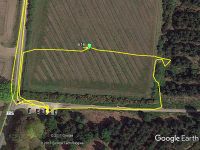
Google Earth Track
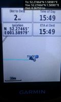
Arrived. @52.2746,1.5898
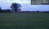
Pig Farming @52.2747,1.5898


Achievements
Expeditions and Plans
| 2017-11-21 | ||
|---|---|---|
| Norwich, United Kingdom | Sourcerer | A meadow at Westleton Heath, Suffolk, UK. |
Sourcerer's Expedition Links
2017-11-18 52 1 - 2017-11-21 52 1 - 2018-01-03 39 27 - KML file download of Sourcerer's expeditions for use with Google Earth.