Difference between revisions of "2018-01-21 49 8"
imported>DODO |
m (Location correction) |
||
| (3 intermediate revisions by 2 users not shown) | |||
| Line 27: | Line 27: | ||
== Expedition == | == Expedition == | ||
| − | I started at half past eleven in the morning. The beginning was quite usual, roads I rode many times. But after a while I reached the flank of the palatine forest. First I had to climb some steep roads, then I left the road and had to go on a sirt road into the forest. What I hadn't expected was snow, becaue down here in the valley was no snow at all. This made riding a little more difficult, especially uphill, when the tires didn't get enough traction so I had to push the bull. Nevertheless, at a quarter to two I reache dthe hash. It was just 20 m into the light forest. I left a mark of trees and another X in the snow. The path got worse from hereon, and I had to push for several times. But in the end I reached the station in Frankenstein. | + | I started at half past eleven in the morning. The beginning was quite usual, roads I rode many times. But after a while I reached the flank of the palatine forest. First I had to climb some steep roads, then I left the road and had to go on a sirt road into the forest. What I hadn't expected was snow, becaue down here in the valley was no snow at all. This made riding a little more difficult, especially uphill, when the tires didn't get enough traction so I had to push the bull. Nevertheless, at a quarter to two I reache dthe hash. It was just 20 m into the light forest. I left a mark of trees and another X in the snow. The path got worse from hereon, and I had to push for several times. But in the end I reached the station in Frankenstein, just when the train arrived. I jumped in and bought my ticket online in the train. So I reched home at a qaurter past three. |
== Tracklog == | == Tracklog == | ||
<!-- if your GPS device keeps a log, you may post a link here --> | <!-- if your GPS device keeps a log, you may post a link here --> | ||
| + | [https://www.komoot.de/tour/26399468 66 KM by bull and 44 by train] | ||
== Photos == | == Photos == | ||
| Line 36: | Line 37: | ||
Image:2012-##-## ## ## Alpha.jpg | Witty Comment | Image:2012-##-## ## ## Alpha.jpg | Witty Comment | ||
--> | --> | ||
| − | <gallery perrow=" | + | <gallery perrow="4"> |
| + | Image:2018-01-21_49_8-1.jpg|first view of snow | ||
| + | Image:2018-01-21_49_8-2.jpg|bull with more snow (near hash) | ||
| + | Image:2018-01-21_49_8-3.jpg|20 m in this direction | ||
| + | Image:2018-01-21_49_8-7.jpg|proof | ||
| + | Image:2018-01-21_49_8-4.jpg|view to the north (west, east and south is pretty miuch the same) | ||
| + | Image:2018-01-21_49_8-5.jpg|happy hasher(tm) | ||
| + | Image:2018-01-21_49_8-6.jpg|build X | ||
| + | Image:2018-01-21_49_8-8.jpg|marked X | ||
</gallery> | </gallery> | ||
== Achievements == | == Achievements == | ||
{{#vardefine:ribbonwidth|800px}} | {{#vardefine:ribbonwidth|800px}} | ||
| − | + | {{land geohash | |
| + | | latitude = 49 | ||
| + | | longitude = 8 | ||
| + | | date = 2018-01-21 | ||
| + | | name = DODO | ||
| + | }} | ||
| − | |||
| − | |||
| − | |||
| − | + | I thought the hp to be in Kreis Bad Dürkheim, but geohashing.info convinced me, that it is in Donnersbergkreis. And then I remarked, that I've gained a shiny ribbon by this: | |
| + | {{Regional geohashing | ||
| + | | name = [[User:DODO|DODO]] | ||
| + | | region = Donnersbergkreis | ||
| + | | count = 2 | ||
| + | }} | ||
| − | |||
| − | |||
| − | |||
| − | |||
| − | |||
| − | |||
| − | |||
[[Category:Expeditions]] | [[Category:Expeditions]] | ||
| − | |||
| − | |||
| − | |||
| − | |||
| − | |||
| − | |||
| − | |||
[[Category:Coordinates reached]] | [[Category:Coordinates reached]] | ||
| − | + | {{location|DE|RP|ROK}} | |
| − | |||
| − | |||
| − | |||
| − | |||
| − | |||
| − | |||
| − | |||
| − | |||
| − | |||
| − | |||
| − | |||
| − | |||
| − | |||
| − | |||
| − | |||
| − | |||
| − | |||
Latest revision as of 20:37, 16 May 2020
| Sun 21 Jan 2018 in 49,8: 49.5071390, 8.0064566 geohashing.info google osm bing/os kml crox |
Location
In the palatine forest near Hertlinghausen.
Participants
Plans
Go there by bull.
Expedition
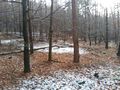
I started at half past eleven in the morning. The beginning was quite usual, roads I rode many times. But after a while I reached the flank of the palatine forest. First I had to climb some steep roads, then I left the road and had to go on a sirt road into the forest. What I hadn't expected was snow, becaue down here in the valley was no snow at all. This made riding a little more difficult, especially uphill, when the tires didn't get enough traction so I had to push the bull. Nevertheless, at a quarter to two I reache dthe hash. It was just 20 m into the light forest. I left a mark of trees and another X in the snow. The path got worse from hereon, and I had to push for several times. But in the end I reached the station in Frankenstein, just when the train arrived. I jumped in and bought my ticket online in the train. So I reched home at a qaurter past three.
Tracklog
Photos
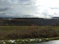
first view of snow
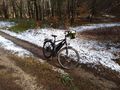
bull with more snow (near hash)
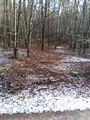
20 m in this direction
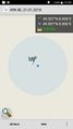
proof
view to the north (west, east and south is pretty miuch the same)
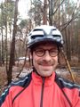
happy hasher(tm)
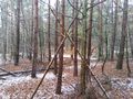
build X
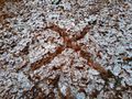
marked X


Achievements
DODO earned the Land geohash achievement
|
I thought the hp to be in Kreis Bad Dürkheim, but geohashing.info convinced me, that it is in Donnersbergkreis. And then I remarked, that I've gained a shiny ribbon by this:
DODO earned the Regional geohashing achievement
|