2018-01-31 43 19
| Wed 31 Jan 2018 in Prijepolje, Serbia: 43.3820538, 19.4510360 geohashing.info google osm bing/os kml crox |
Location
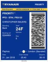
Half way between and 11.5 km above Krnjača and Jabuka, Serbia, flying at around 800 km/h. Thanks, Ryanair - you nailed this one.
Participants
Plans
All my journeys by air seek the Air_geohash_achievement. The 10 arc second rule means you need to be under 310 metres from the hashpoint. My napkin aproximath suggests there as a 0.1% chance of meeting this goal crossing one graticule. On a mid length flight you might cross 50 graticules so now there's a 5% chance of success. Frequent flyers will certainly succeed eventually.
Expedition
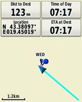
I had programmed the decimal parts of the coordinates into my Garmin eTrex 20. Every 10 to 15 minutes I re-programmed the graticule coordinates and watched the distances fall and rise again. In 43,19 the distance was dropping rapidly and after each screen update I was grabbing the image. The best screen shot was at 123 metres from the hashpoint, well within the requirements.
A bit of post-processing in Google Earth confirmed the result.
The eTrex 20 lacks a barometric altimeter so you get true altitude in an aircraft and not the cabin pressure altitude.
Photos
- Gallery
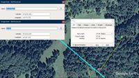
Google Earth Proof
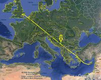
FLight Path
GPSr Proof
Proof of Flight


Achievements
Expeditions and Plans
| 2018-01-31 | ||
|---|---|---|
| Prijepolje, Serbia | Sourcerer | Half way between and 11.5 km above Krnjača and Jabuka, Montenegro, flying a... |
| Norwich, United Kingdom | Sourcerer | A field perimeter footpath at Rumburgh, Suffolk UK. |
Sourcerer's Expedition Links
2018-01-03 39 27 - 2018-01-31 43 19 - 2018-01-31 52 1 - KML file download of Sourcerer's expeditions for use with Google Earth.