Difference between revisions of "2018-02-17 52 13"
From Geohashing
m (Location correction) |
|||
| Line 1: | Line 1: | ||
| − | |||
| − | |||
| − | |||
| − | |||
| − | |||
| − | |||
| − | |||
| − | |||
| − | |||
| − | |||
{{meetup graticule | {{meetup graticule | ||
| lat=52 | | lat=52 | ||
| Line 14: | Line 4: | ||
| date=2018-02-17 | | date=2018-02-17 | ||
}} | }} | ||
| − | |||
| − | |||
__NOTOC__ | __NOTOC__ | ||
== Location == | == Location == | ||
| − | + | This Geohash is located in a forest near Groß Glienicke. | |
== Participants == | == Participants == | ||
| − | + | *[[User:grumpy-nerd|grumpy-nerd]] | |
| − | |||
| − | |||
| − | |||
| − | |||
== Expedition == | == Expedition == | ||
| − | + | My first one! GPS was terrible and no network either, but according to the app I was there +/- 17 meters. | |
| − | |||
| − | |||
| − | |||
== Photos == | == Photos == | ||
| − | |||
| − | |||
| − | |||
<gallery perrow="5"> | <gallery perrow="5"> | ||
| − | + | Image:2018-02-17_52_13_grumpy-nerd_1518883418949.jpg | Proof | |
| − | Image:2018-02-17_52_13_grumpy-nerd_1518883418949.jpg| | ||
</gallery> | </gallery> | ||
Latest revision as of 21:58, 10 June 2021
| Sat 17 Feb 2018 in 52,13: 52.4843692, 13.1333854 geohashing.info google osm bing/os kml crox |
Location
This Geohash is located in a forest near Groß Glienicke.
Participants
Expedition
My first one! GPS was terrible and no network either, but according to the app I was there +/- 17 meters.
Photos
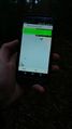
Proof
