Difference between revisions of "2018-05-26 52 -0"
imported>Sourcerer m ([live picture] Tongs. [http://www.openstreetmap.org/?lat=52.04136729&lon=-.02033651&zoom=16&layers=B000FTF @52.0414,-.0203]) |
imported>Sourcerer m (→Expedition) |
||
| Line 29: | Line 29: | ||
== Expedition == | == Expedition == | ||
| − | + | [[User:Sourcerer|Sourcerer]] set out by car at 13:30 expecting a two hour journey avoiding the popular air show at Duxford. The traffic was surprisingly light for a bank holiday long weekend. The evidence photo was snapped at 15:21. Both Sourcerer and Tongs/B are licensed radio amateurs and we were able to talk by radio on 145.5 MHz as Tongs/B made his approach 15 minutes later. We then sat on a grassy bank beside the hashpoint and chatted for a while giving time for anyone else to show up, No one else did though. We fear the hobby is dieing out. [[User:Randall]] needs to do another cartoon! | |
| − | |||
== Photos == | == Photos == | ||
Revision as of 19:15, 26 May 2018
| Sat 26 May 2018 in Northampton: 52.0413542, -0.0203118 geohashing.info google osm bing/os kml crox |
Location
A roadside point a mile south of Royston railway station, Hertfordshire, UK.
The link from the map to the right appears to be broken and linking to the wrong hashpoint!
From Sourcerer's description I think we're going for (52.041354154131255, -0.02031179801003233).
carabiner.peeron.com/xkcd/map/map.html is broken too. It fails to retrieve the DOW.
Participants
- Sourcerer
- Tongs/B but not the other Tongs, who are away for the weekend.
Plans
Visit at 4pm unless we agree a different time on the discussion page. I'll bring my 2 metre rig and listen on 145.5 MHz.
Expedition
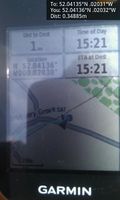
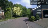
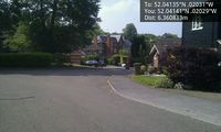
Sourcerer set out by car at 13:30 expecting a two hour journey avoiding the popular air show at Duxford. The traffic was surprisingly light for a bank holiday long weekend. The evidence photo was snapped at 15:21. Both Sourcerer and Tongs/B are licensed radio amateurs and we were able to talk by radio on 145.5 MHz as Tongs/B made his approach 15 minutes later. We then sat on a grassy bank beside the hashpoint and chatted for a while giving time for anyone else to show up, No one else did though. We fear the hobby is dieing out. User:Randall needs to do another cartoon!
Photos
- Gallery
Arrived. @52.0414,-.0203
HP. @52.0414,-.0203
HP. @52.0414,-.0203
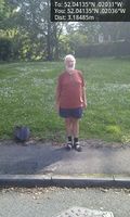
Sourcerer. @52.0414,-.0204

Tongs. @52.0414,-.0203


Achievements
Expeditions and Plans
| 2018-05-26 | ||
|---|---|---|
| Johannesburg (East), South Africa | Theblazehen | On the golf course at the campus |
| Hamilton, New Zealand | Krintar | Somewhere |
| Gastonia, North Carolina | OtherJack | Woods near a golf course in Tega Cay, near Lake Wylie. |
| Northampton, United Kingdom | Sourcerer, Tongs/B | A roadside point a mile south of Royston railway station, Hertfordshire, UK... |
| Cambridge, United Kingdom | Someone went | An arable field close to the meridian. 2018-05-26 52 -0 is much more convenient, one mile s... |
Sourcerer's Expedition Links
2018-05-21_52_1 - 2018-05-26_52_-0 - 2018-05-27_52_1 - KML file download of Sourcerer's expeditions for use with Google Earth.