Difference between revisions of "2018-06-15 45 -121"
imported>Frogman (→Location) |
imported>FippeBot m (Location) |
||
| (2 intermediate revisions by one other user not shown) | |||
| Line 1: | Line 1: | ||
| − | + | [[Image:{{{image|2018-06-15 45 -121 frogman 1530490113920.jpg}}}|thumb|left]] | |
| − | |||
| − | |||
| − | |||
| − | |||
| − | |||
| − | |||
| − | |||
{{meetup graticule | {{meetup graticule | ||
| lat=45 | | lat=45 | ||
| Line 25: | Line 18: | ||
<!-- who attended: If you link to your wiki user name in this section, your expedition will be picked up by the various statistics generated for geohashing. You may use three tildes ~ as a shortcut to automatically insert the user signature of the account you are editing with. | <!-- who attended: If you link to your wiki user name in this section, your expedition will be picked up by the various statistics generated for geohashing. You may use three tildes ~ as a shortcut to automatically insert the user signature of the account you are editing with. | ||
--> | --> | ||
| + | *[[User:Frogman|Frogman]] | ||
| + | *[[User:Higgs|Higgs]] | ||
== Plans == | == Plans == | ||
<!-- what were the original plans --> | <!-- what were the original plans --> | ||
| + | We were going to just kinda hang out all day, but then we talked each other into going for a geohashing expedition. | ||
== Expedition == | == Expedition == | ||
<!-- how it all turned out. your narrative goes here. --> | <!-- how it all turned out. your narrative goes here. --> | ||
| + | The drive out to the hashpoint was beautiful! Clear skies, nice views of the mountain. We drove east on US-26 and then north OR-35 until a small gravel road turnoff. Just as we were getting there, a log truck pulled out onto the highway. We were glad that we didn't encounter it going up the narrow logging road! | ||
| − | + | After a while the road started getting narrow and steep, and there was a reasonable turnoff point, so we parked and walked the rest of the way. We happened to park near some beehives! The hashpoint itself was on a steep incline surrounded by a thicket. Luckily we were able to get close enough to be within GPS margin of error before we had to go traipsing through the poison oak. | |
| − | + | ||
| + | On our way back a bird spooked us! It hissed at us, probably to scare us away from its nest. The tactic work, as we beat a hasty retreat. | ||
| + | |||
| + | We drove back on I-84 through the gorge which was also quite lovely to look at. | ||
== Photos == | == Photos == | ||
| Line 60: | Line 60: | ||
<!-- Add any achievement ribbons you earned below, or remove this section --> | <!-- Add any achievement ribbons you earned below, or remove this section --> | ||
| − | + | {{Minesweeper geohash | |
| − | + | | graticule = Portland, Oregon | |
| − | [[ | + | | ranknumber = 5 |
| − | + | | sw = true | |
| − | + | | s = true | |
| + | | se = true | ||
| + | | w = true | ||
| + | | e = true | ||
| + | | name = [[User:Frogman|Frogman]] | ||
| + | }} | ||
| + | {{Minesweeper geohash | ||
| + | | graticule = Springfield, Oregon | ||
| + | | ranknumber = 6 | ||
| + | | n = true | ||
| + | | nw = true | ||
| + | | ne = true | ||
| + | | se = true | ||
| + | | w = true | ||
| + | | e = true | ||
| + | | name = [[User:Frogman|Frogman]] | ||
| + | }} | ||
| + | {{Minesweeper geohash | ||
| + | | graticule = The Dalles, Oregon | ||
| + | | ranknumber = 4 | ||
| + | | w = true | ||
| + | | sw = true | ||
| + | | s = true | ||
| + | | se = true | ||
| + | | name = [[User:Frogman|Frogman]] | ||
| + | }} | ||
| + | {{Minesweeper geohash | ||
| + | | graticule = Bend, Oregon | ||
| + | | ranknumber = 5 | ||
| + | | n = true | ||
| + | | nw = true | ||
| + | | w = true | ||
| + | | e = true | ||
| + | | s = true | ||
| + | | name = [[User:Frogman|Frogman]] | ||
| + | }} | ||
| + | {{Minesweeper geohash | ||
| + | | graticule = Prineville, Oregon | ||
| + | | ranknumber = 4 | ||
| + | | nw = true | ||
| + | | w = true | ||
| + | | sw = true | ||
| + | | e = true | ||
| + | | name = [[User:Frogman|Frogman]] | ||
| + | }} | ||
| − | |||
| − | |||
| − | |||
| − | |||
| − | |||
| − | |||
[[Category:Expeditions]] | [[Category:Expeditions]] | ||
| − | |||
[[Category:Expeditions with photos]] | [[Category:Expeditions with photos]] | ||
| − | |||
| − | |||
| − | |||
| − | |||
| − | |||
[[Category:Coordinates reached]] | [[Category:Coordinates reached]] | ||
| − | + | {{location|US|OR|HO}} | |
| − | |||
| − | |||
| − | |||
| − | |||
| − | |||
| − | |||
| − | |||
| − | |||
| − | |||
| − | |||
| − | |||
| − | |||
| − | |||
| − | |||
| − | |||
| − | |||
| − | |||
Latest revision as of 03:08, 7 August 2019

| Fri 15 Jun 2018 in 45,-121: 45.5704817, -121.5916325 geohashing.info google osm bing/os kml crox |
Location
Off of a logging road between Mt. Hood and Hood River.
Participants
Plans
We were going to just kinda hang out all day, but then we talked each other into going for a geohashing expedition.
Expedition
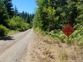
The drive out to the hashpoint was beautiful! Clear skies, nice views of the mountain. We drove east on US-26 and then north OR-35 until a small gravel road turnoff. Just as we were getting there, a log truck pulled out onto the highway. We were glad that we didn't encounter it going up the narrow logging road!
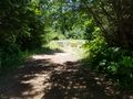
After a while the road started getting narrow and steep, and there was a reasonable turnoff point, so we parked and walked the rest of the way. We happened to park near some beehives! The hashpoint itself was on a steep incline surrounded by a thicket. Luckily we were able to get close enough to be within GPS margin of error before we had to go traipsing through the poison oak.
On our way back a bird spooked us! It hissed at us, probably to scare us away from its nest. The tactic work, as we beat a hasty retreat.
We drove back on I-84 through the gorge which was also quite lovely to look at.
Photos
Bees!
Logging road
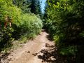
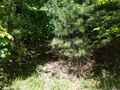
A smaller side path.
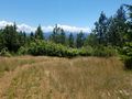
View!
Made it!
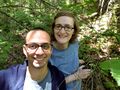
Grins
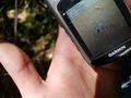
The hashpoint, approximately


Achievements
Frogman achieved level 5 of the Minesweeper Geohash achievement
|
Frogman achieved level 6 of the Minesweeper Geohash achievement
|
Frogman achieved level 4 of the Minesweeper Geohash achievement
|
Frogman achieved level 5 of the Minesweeper Geohash achievement
|
Frogman achieved level 4 of the Minesweeper Geohash achievement
|