Difference between revisions of "2018-08-04 51 -1"
imported>DanQ (→Expedition) |
(→Tracklog) |
||
| (6 intermediate revisions by 2 users not shown) | |||
| Line 1: | Line 1: | ||
| + | {{User:DanQ/Template:DanQBlog | url = https://danq.me/2018/08/04/geohashing-expedition-2018-08-04-51-1/ }} | ||
| − | + | {{Advert}} | |
| − | |||
| − | |||
| − | |||
| − | |||
| − | |||
| − | |||
| − | |||
{{meetup graticule | {{meetup graticule | ||
| lat=51 | | lat=51 | ||
| Line 18: | Line 12: | ||
__NOTOC__ | __NOTOC__ | ||
| − | |||
| − | |||
== Location == | == Location == | ||
| − | |||
Looks to be deep in the bushes alongside the unnamed road that connects Kidlington Road (to Islip), the sliproad exiting the A34 Southbound, and Bicester Road (in Kidlington). | Looks to be deep in the bushes alongside the unnamed road that connects Kidlington Road (to Islip), the sliproad exiting the A34 Southbound, and Bicester Road (in Kidlington). | ||
== Participants == | == Participants == | ||
| − | |||
| − | |||
* [[User:DanQ|Dan Q]] | * [[User:DanQ|Dan Q]] | ||
== Plans == | == Plans == | ||
| − | + | The nearest road is about 10 minutes cycle from my ([[User:DanQ|Dan Q]]) house, so I plan to zip out there either overnight (perhaps aiming for a [[Midnight Geohash]]?) or early in the morning. If you happen to plan to hit this hashpoint too, though, let me know and I can try to synchronise plans (but I ''ought'' to be spending the day studying, so I might not be able to!). | |
| − | The nearest road is about 10 minutes cycle from my ([[User:DanQ|Dan Q]]) house, so I | ||
== Expedition == | == Expedition == | ||
| − | |||
| − | 2018-08-03 23:02 BST | + | At 2018-08-03 23:02 (BST - local time) I started packing a bag and set out to the hashpoint. Suddenly it didn't seem like such a good idea as it had in the warm sunlight, earlier: a dark and moonless night isn't the best time to be cycling along unlit roads. But fully-equipped with lights and supplies, I set out nonetheless. I'd left longer than I needed and had about a quarter of an hour sitting by the side of the road before midnight came and I was able to visit the hashpoint (thereby gaining my Midnight Achievement). |
| − | + | == Tracklog == | |
| − | + | * [https://danq.me/wp-content/uploads/2018/08/Track_2018-08-04%20HASH%2051,%20-1.gpx GPX tracklog] | |
| − | + | ||
| + | {{tracklog | Track_2018-08-04_HASH_51,_-1.gpx}} | ||
== Photos == | == Photos == | ||
| − | |||
| − | |||
| − | |||
<gallery perrow="5"> | <gallery perrow="5"> | ||
| + | Image:2018-08-04 51 -1 DanQ B.jpg | Ready to set out on the expedition. Man, it's dark outside! | ||
| + | Image:2018-08-04_51 -1 DanQ D.jpg | My transport for this expedition. | ||
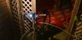
| + | Image:2018-08-04_51 -1 DanQ I.jpg | A convenient roadside barrier just 6m from the hashpoint provides a place to zip-tie a laminated sign. | ||
| + | Image:2018-08-04_51 -1 DanQ X.jpg | Success! (With Silly Grin) | ||
</gallery> | </gallery> | ||
| + | |||
| + | See also a GIF of me accidentally reenacting a scene from ''The Blair Witch Project'' while out in the woods: https://danq.me/wp-content/uploads/2018/08/2018-08-04_51_-1__DanQ__Scared_square.gif | ||
== Achievements == | == Achievements == | ||
{{#vardefine:ribbonwidth|800px}} | {{#vardefine:ribbonwidth|800px}} | ||
| − | + | {{Midnight geohash | |
| − | + | | latitude = 51 | |
| − | + | | longitude = -1 | |
| − | + | | date = 2018-08-04 | |
| − | + | | name = DanQ | |
| − | + | }} | |
| − | |||
| − | |||
| − | |||
[[Category:Expeditions]] | [[Category:Expeditions]] | ||
| − | |||
[[Category:Expeditions with photos]] | [[Category:Expeditions with photos]] | ||
| − | |||
| − | |||
| − | |||
| − | |||
| − | |||
[[Category:Coordinates reached]] | [[Category:Coordinates reached]] | ||
| − | + | {{location|GB|ENG|OXF}} | |
| − | |||
| − | |||
| − | |||
| − | |||
| − | |||
| − | |||
| − | |||
| − | |||
| − | |||
| − | |||
| − | |||
| − | |||
| − | |||
| − | |||
| − | |||
| − | |||
| − | |||
Latest revision as of 08:46, 24 February 2020
|
Dan Q also wrote about this expedition on his blog. For more details and higher-resolution pictures, see this expedition's log at https://danq.me/2018/08/04/geohashing-expedition-2018-08-04-51-1/ |
| Have you seen our geohashing marker? We'd love to hear from you! Click here to say "hi" and tell us what you've seen!
Curious about what geohashing is? Read more! |
| Sat 4 Aug 2018 in 51,-1: 51.8249560, -1.2609510 geohashing.info google osm bing/os kml crox |
Location
Looks to be deep in the bushes alongside the unnamed road that connects Kidlington Road (to Islip), the sliproad exiting the A34 Southbound, and Bicester Road (in Kidlington).
Participants
Plans
The nearest road is about 10 minutes cycle from my (Dan Q) house, so I plan to zip out there either overnight (perhaps aiming for a Midnight Geohash?) or early in the morning. If you happen to plan to hit this hashpoint too, though, let me know and I can try to synchronise plans (but I ought to be spending the day studying, so I might not be able to!).
Expedition
At 2018-08-03 23:02 (BST - local time) I started packing a bag and set out to the hashpoint. Suddenly it didn't seem like such a good idea as it had in the warm sunlight, earlier: a dark and moonless night isn't the best time to be cycling along unlit roads. But fully-equipped with lights and supplies, I set out nonetheless. I'd left longer than I needed and had about a quarter of an hour sitting by the side of the road before midnight came and I was able to visit the hashpoint (thereby gaining my Midnight Achievement).
Tracklog
Photos

Ready to set out on the expedition. Man, it's dark outside!
My transport for this expedition.
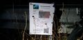
A convenient roadside barrier just 6m from the hashpoint provides a place to zip-tie a laminated sign.
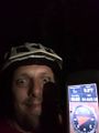
Success! (With Silly Grin)


See also a GIF of me accidentally reenacting a scene from The Blair Witch Project while out in the woods: https://danq.me/wp-content/uploads/2018/08/2018-08-04_51_-1__DanQ__Scared_square.gif
Achievements
DanQ earned the Midnight Geohash achievement
|