Difference between revisions of "2018-08-07 51 -1"
imported>DanQ |
(→Video: Embedded video) |
||
| (4 intermediate revisions by 2 users not shown) | |||
| Line 1: | Line 1: | ||
| + | {{User:DanQ/Template:DanQBlog | url = https://danq.me/2018/08/07/geohashing-expedition-2018-08-07-51-1/ }} | ||
| − | |||
| − | |||
| − | |||
| − | |||
| − | |||
| − | |||
| − | |||
| − | |||
| − | |||
{{meetup graticule | {{meetup graticule | ||
| lat=51 | | lat=51 | ||
| Line 28: | Line 20: | ||
== Expedition == | == Expedition == | ||
| − | + | After a productive morning's work, I was genuinely slightly disappointed that a meeting I was scheduled to have this afternoon had to be rescheduled. But on the other hand... that meant that I could get away with extending my lunch break slightly and getting out to the hashpoint! I'd initially worried that it'd be inaccessibly buried on private land when Google Maps and satellite photography showed it to be deep in a block of cornfields, but OpenStreetMap came to the rescue and showed a public footpath somewhere in the very close vicinity of the target coordinates. And so, jumping aboard my bike, I set out! | |
| + | |||
| + | 600m from the coordinates I ran out of road and switched to the footpath, which I was pleased to discover was in reasonably-good condition: many underused local footpaths are not being very well-maintained at the moment and are often overgrown, but I was even able to bring my bike along this one and into the first field, although I had to push it rather than ride and I soon learned the error of my ways when the terrain got even rougher and I reached a narrow bridge - too narrow for my bike - spanning a dyke and entering the second field. Both fields had recently been cleared of corn, and whatever route the official footpath was supposed to take became rapidly unclear, but that's probably for the best because I'm pretty sure I wasn't on it by the time I reached the edge of the next field. | ||
| + | |||
| + | The hashpoint seemed to be along the fence somewhere so I followed it along - waving to some nearby cows - until my phone told me that I was under 3m from the spot. Hurrah! I snapped a panorama photo and started heading back, pausing a few times when I realised that I really, really couldn't find where I'd left my bike. On the cycle home I passed a [https://en.wikipedia.org/wiki/Gas_holder Gasometer] which, because I'm told they're super-rare in the USA, I thought I'd snap a picture of for those of you who 'hash on the other side of the pond to oggle at. | ||
| + | |||
| + | == Video == | ||
| + | |||
| + | I actually remembered to shoot video of this expedition (well, all within a kilometre of the hashpoint and mostly within the last 350 metres!). It's mostly just me rambling as I ramble, although there's (brief) explanation of the Surprise Gasometer for those of you who live in countries where you don't routinely see these interesting structures: '''[https://www.youtube.com/watch?v=a3mMjo4NxMo Watch on YouTube]''' or below: | ||
| + | |||
| + | <youtube>https://www.youtube.com/watch?v=a3mMjo4NxMo Watch on YouTube</youtube> | ||
== Photos == | == Photos == | ||
| Line 43: | Line 45: | ||
</gallery> | </gallery> | ||
| − | == | + | == Further reading == |
| − | |||
| − | |||
| − | + | This hashlog is also published (along with more and higher-resolution photos) at https://danq.me/2018/08/07/geohashing-expedition-2018-08-07-51-1/ | |
| − | |||
| − | |||
| − | |||
| − | |||
| − | |||
| − | |||
| − | |||
| − | |||
| − | |||
| − | |||
| − | |||
| − | |||
[[Category:Expeditions]] | [[Category:Expeditions]] | ||
| − | |||
[[Category:Expeditions with photos]] | [[Category:Expeditions with photos]] | ||
[[Category:Expeditions with videos]] | [[Category:Expeditions with videos]] | ||
| − | |||
| − | |||
| − | |||
| − | |||
[[Category:Coordinates reached]] | [[Category:Coordinates reached]] | ||
| − | + | {{location|GB|ENG|OXF}} | |
| − | |||
| − | |||
| − | |||
| − | |||
| − | |||
| − | |||
| − | |||
| − | |||
| − | |||
| − | |||
| − | |||
| − | |||
| − | |||
| − | |||
| − | |||
| − | |||
| − | |||
Latest revision as of 21:56, 26 February 2020
|
Dan Q also wrote about this expedition on his blog. For more details and higher-resolution pictures, see this expedition's log at https://danq.me/2018/08/07/geohashing-expedition-2018-08-07-51-1/ |
| Tue 7 Aug 2018 in 51,-1: 51.7210189, -1.1785690 geohashing.info google osm bing/os kml crox |
Location
A field South of Oxford.
Participants
Plans
My meeting this afternoon got cancelled and my nearest hashpoint is only 6.5km (4 miles) away from my office. I can get this!
Expedition
After a productive morning's work, I was genuinely slightly disappointed that a meeting I was scheduled to have this afternoon had to be rescheduled. But on the other hand... that meant that I could get away with extending my lunch break slightly and getting out to the hashpoint! I'd initially worried that it'd be inaccessibly buried on private land when Google Maps and satellite photography showed it to be deep in a block of cornfields, but OpenStreetMap came to the rescue and showed a public footpath somewhere in the very close vicinity of the target coordinates. And so, jumping aboard my bike, I set out!
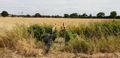
600m from the coordinates I ran out of road and switched to the footpath, which I was pleased to discover was in reasonably-good condition: many underused local footpaths are not being very well-maintained at the moment and are often overgrown, but I was even able to bring my bike along this one and into the first field, although I had to push it rather than ride and I soon learned the error of my ways when the terrain got even rougher and I reached a narrow bridge - too narrow for my bike - spanning a dyke and entering the second field. Both fields had recently been cleared of corn, and whatever route the official footpath was supposed to take became rapidly unclear, but that's probably for the best because I'm pretty sure I wasn't on it by the time I reached the edge of the next field.
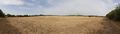
The hashpoint seemed to be along the fence somewhere so I followed it along - waving to some nearby cows - until my phone told me that I was under 3m from the spot. Hurrah! I snapped a panorama photo and started heading back, pausing a few times when I realised that I really, really couldn't find where I'd left my bike. On the cycle home I passed a Gasometer which, because I'm told they're super-rare in the USA, I thought I'd snap a picture of for those of you who 'hash on the other side of the pond to oggle at.
Video
I actually remembered to shoot video of this expedition (well, all within a kilometre of the hashpoint and mostly within the last 350 metres!). It's mostly just me rambling as I ramble, although there's (brief) explanation of the Surprise Gasometer for those of you who live in countries where you don't routinely see these interesting structures: Watch on YouTube or below:
Photos

Just 6.5km from work to the hashpoint... if only my bike could fly...

On my bike and ready to go!
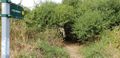
This footpath is in better condition than I expected it to be. I can even get my bike down it.
Rough ground in the first field: should have left my bike back at the road!
Definitely as far as the bike will go today. On foot, from here...

Success! No "proper" GPSr with me today, so screenshot only, no tracklog.
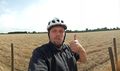
Silly-ish grin at the hashpoint (with cows in the background).
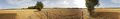
Panorama from the hashpoint. Ignoring the pylons, there's a whole lot of nothing.
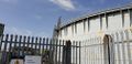
Surprise gasometer I spotted on the way home! For the benefit of hashers in the States, where I gather these are even rarer than they are in the UK, and who might not have seen one before.


Further reading
This hashlog is also published (along with more and higher-resolution photos) at https://danq.me/2018/08/07/geohashing-expedition-2018-08-07-51-1/