Difference between revisions of "2019-02-13 51 0"
From Geohashing
imported>Sourcerer m ([live picture] Arrived. [http://www.openstreetmap.org/?lat=51.96060598&lon=.43540299&zoom=16&layers=B000FTF @51.9606,.4354]) |
imported>Sourcerer m (→New expedition) |
||
| Line 1: | Line 1: | ||
| − | |||
| − | |||
| − | |||
| − | |||
| − | |||
| − | |||
| − | |||
| − | |||
| − | |||
| − | |||
{{meetup graticule | {{meetup graticule | ||
| lat=51 | | lat=51 | ||
| lon=0 | | lon=0 | ||
| date=2019-02-13 | | date=2019-02-13 | ||
| + | | graticule_name=London East | ||
| + | | graticule_link=London East, United Kingdom | ||
}} | }} | ||
| + | __NOTOC__ | ||
| + | == Location == | ||
| + | |||
| + | 1.4 km north of Great Bardfield, Esset, UK. | ||
| − | + | == Planning == | |
| − | |||
| − | + | Visit 52 graticules. Hope to hit a hashpoint. | |
| − | |||
== Participants == | == Participants == | ||
| − | |||
| − | |||
| − | + | * [[User:Sourcerer|Sourcerer]] | |
| − | |||
== Expedition == | == Expedition == | ||
| − | |||
| − | |||
| − | |||
| − | |||
| − | |||
| − | |||
| − | |||
| − | |||
| − | |||
| + | == Photos == | ||
| + | <gallery caption="Gallery" widths="200px" heights="200px" perrow="3"> | ||
Image:2019-02-13_51_0_Sourcerer_1550057033133.jpg | Arrived. [http://www.openstreetmap.org/?lat=51.96060598&lon=.43540299&zoom=16&layers=B000FTF @51.9606,.4354] | Image:2019-02-13_51_0_Sourcerer_1550057033133.jpg | Arrived. [http://www.openstreetmap.org/?lat=51.96060598&lon=.43540299&zoom=16&layers=B000FTF @51.9606,.4354] | ||
</gallery> | </gallery> | ||
== Achievements == | == Achievements == | ||
| − | |||
| − | |||
| − | + | {{Sourcerer_links | |
| − | + | | prev = 2019-01-09 49 8 | |
| − | + | | curr = 2019-02-13_51_0 | |
| + | | next = 2019-02-14_52_1 | ||
| + | | date = 2019-02-03 | ||
| + | }} | ||
| − | |||
| − | |||
| − | |||
| − | |||
| − | |||
| − | |||
| − | |||
| − | |||
| − | |||
| − | |||
[[Category:Expeditions]] | [[Category:Expeditions]] | ||
| − | |||
[[Category:Expeditions with photos]] | [[Category:Expeditions with photos]] | ||
| − | |||
| − | |||
| − | |||
| − | |||
| − | |||
| − | |||
| − | |||
[[Category:Coordinates reached]] | [[Category:Coordinates reached]] | ||
| − | |||
| − | |||
| − | |||
| − | |||
| − | |||
| − | |||
| − | |||
| − | |||
| − | |||
| − | |||
| − | |||
| − | |||
| − | |||
| − | |||
| − | |||
| − | |||
| − | |||
| − | |||
Revision as of 08:18, 14 February 2019
| Wed 13 Feb 2019 in London East: 51.9606014, 0.4354559 geohashing.info google osm bing/os kml crox |
Location
1.4 km north of Great Bardfield, Esset, UK.
Planning
Visit 52 graticules. Hope to hit a hashpoint.
Participants
Expedition
Photos
- Gallery
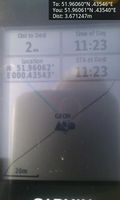
Arrived. @51.9606,.4354

Achievements
Expeditions and Plans
| 2019-02-03 | ||
|---|---|---|
| McMinnville, Oregon | Michael5000 | On Briedwell Road in the farmland northwest of Amity. |
| Frankfurt am Main, Germany | Mampfred, QuarterCacher, EmmJay | In the woods not far from the "Hubertushütte". |
| Stralsund, Germany | SastRe.O | In a field south-east of Horst (MV, Deutschland) |
Sourcerer's Expedition Links
2019-01-09 49 8 - 2019-02-13_51_0 - 2019-02-14_52_1 - KML file download of Sourcerer's expeditions for use with Google Earth.