Difference between revisions of "2019-03-23 43 -120"
imported>FippeBot m (Location) |
Michael5000 (talk | contribs) m (→Expedition) |
||
| Line 28: | Line 28: | ||
== Expedition == | == Expedition == | ||
| − | Waking up in Prineville (see [[2019-03-22 44 -120]]), I drove south on Oregon | + | Waking up in Prineville (see [[2019-03-22 44 -120]]), I drove south on Oregon 27 (scenic but twisty) to US 20 (straight but not very scenic), stopping at Brothers at a cafe out of a Western movie for coffee, before continuing east to the intersection with US 385. Ten miles south of there, I pulled off on a side road and went for a run, two and a half miles out and back. I didn't see a moving thing until I got back to the car. |
I resumed driving through intermittent heavy rain, to the Christmas Valley highway, which I followed about 12 miles in to the point where the hashpoint road branches off. Again, I parked the car and went in by foot. The rain held off, it was a pleasant walk, and I got to see what a sagebrush plain looks like in late winter. | I resumed driving through intermittent heavy rain, to the Christmas Valley highway, which I followed about 12 miles in to the point where the hashpoint road branches off. Again, I parked the car and went in by foot. The rain held off, it was a pleasant walk, and I got to see what a sagebrush plain looks like in late winter. | ||
Latest revision as of 00:21, 30 April 2023
| Sat 23 Mar 2019 in 43,-120: 43.2213311, -120.1555120 geohashing.info google osm bing/os kml crox |
Location
About a half-mile north from the Christmas Valley Highway.
Participants
Expedition
Waking up in Prineville (see 2019-03-22 44 -120), I drove south on Oregon 27 (scenic but twisty) to US 20 (straight but not very scenic), stopping at Brothers at a cafe out of a Western movie for coffee, before continuing east to the intersection with US 385. Ten miles south of there, I pulled off on a side road and went for a run, two and a half miles out and back. I didn't see a moving thing until I got back to the car.
I resumed driving through intermittent heavy rain, to the Christmas Valley highway, which I followed about 12 miles in to the point where the hashpoint road branches off. Again, I parked the car and went in by foot. The rain held off, it was a pleasant walk, and I got to see what a sagebrush plain looks like in late winter.
I got back out (obviously), drove back to US 385, and continued one degree of latitude south to 2019-03-23 42 -120.
Photos
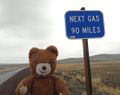
This adventure involved a lot of rural driving.
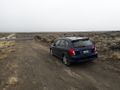
The car got me to within about a half mile of the hashpoint.
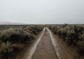
From there, it was a cold walk down a dirt road through sagebrush.
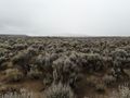
From the hashpoint, the view was mostly sagebrush.

And there I was!


.jpg)
Achievements
Michael5000 earned the Multihash Achievement
|
Michael5000 achieved level 6 of the Minesweeper Geohash achievement
|
Michael5000 achieved level 6 of the Minesweeper Geohash achievement
|
Michael5000 achieved level 5 of the Minesweeper Geohash achievement
|