Difference between revisions of "2019-05-28 45 -122"
From Geohashing
imported>Michael5000 (Created page with "{{subst:Expedition |lat = 45 |lon = -122 |date = 2019-05-28 }}") |
Michael5000 (talk | contribs) |
||
| (2 intermediate revisions by 2 users not shown) | |||
| Line 1: | Line 1: | ||
| − | |||
| − | |||
| − | |||
| − | |||
| − | |||
| − | |||
| − | |||
| − | |||
| − | |||
{{meetup graticule | {{meetup graticule | ||
| lat=45 | | lat=45 | ||
| Line 17: | Line 8: | ||
<!-- edit as necessary --> | <!-- edit as necessary --> | ||
__NOTOC__ | __NOTOC__ | ||
| + | == Location == | ||
| − | + | On the 12700 block of SE Madison Street, near David Douglas High School. | |
| − | |||
== Participants == | == Participants == | ||
| − | |||
| − | |||
| − | + | [[User:Michael5000|Michael5000]] | |
| − | |||
== Expedition == | == Expedition == | ||
| − | |||
| − | + | The hashpoint was on a residential street about two miles from work, maybe a mile from a restaurant that I like to eat lunch at. So, I visited the spot on my lunch break. Good story, right? | |
| − | |||
== Photos == | == Photos == | ||
| − | + | ||
| − | |||
| − | |||
<gallery perrow="5"> | <gallery perrow="5"> | ||
| + | File:2019-05-28 45 -122 car.jpg|The Expedition vehicle sits insouciantly atop the hashpoint. | ||
| + | File:2019-05-28 45 -122 screen.jpg|I didn't have the regular GPS gadget along, so I used the phone app. Pretty good. | ||
</gallery> | </gallery> | ||
== Achievements == | == Achievements == | ||
{{#vardefine:ribbonwidth|800px}} | {{#vardefine:ribbonwidth|800px}} | ||
| − | |||
| − | |||
| − | |||
| − | |||
| − | |||
| − | |||
| − | |||
| − | |||
| − | |||
| − | |||
| − | |||
| − | |||
| − | |||
| − | |||
| − | |||
| − | |||
[[Category:Expeditions]] | [[Category:Expeditions]] | ||
| − | |||
| − | |||
| − | |||
| − | |||
| − | |||
| − | |||
| − | |||
| − | |||
| − | |||
[[Category:Coordinates reached]] | [[Category:Coordinates reached]] | ||
| − | + | {{location|US|OR|MU}} | |
| − | |||
| − | |||
| − | |||
| − | |||
| − | |||
| − | |||
| − | |||
| − | |||
| − | |||
| − | |||
| − | |||
| − | |||
| − | |||
| − | |||
| − | |||
| − | |||
| − | |||
Latest revision as of 20:29, 16 April 2022
| Tue 28 May 2019 in 45,-122: 45.5131297, -122.5317133 geohashing.info google osm bing/os kml crox |
Location
On the 12700 block of SE Madison Street, near David Douglas High School.
Participants
Expedition
The hashpoint was on a residential street about two miles from work, maybe a mile from a restaurant that I like to eat lunch at. So, I visited the spot on my lunch break. Good story, right?
Photos
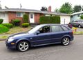
The Expedition vehicle sits insouciantly atop the hashpoint.
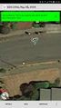
I didn't have the regular GPS gadget along, so I used the phone app. Pretty good.

