Difference between revisions of "2019-08-02 45 -120"
imported>Michael5000 |
m (Location) |
||
| (One intermediate revision by one other user not shown) | |||
| Line 41: | Line 41: | ||
{{#vardefine:ribbonwidth|800px}} | {{#vardefine:ribbonwidth|800px}} | ||
<!-- Add any achievement ribbons you earned below, or remove this section --> | <!-- Add any achievement ribbons you earned below, or remove this section --> | ||
| − | |||
| − | |||
| − | |||
| − | |||
| − | |||
| − | |||
| − | |||
[[Category:Expeditions]] | [[Category:Expeditions]] | ||
[[Category:Expeditions with photos]] | [[Category:Expeditions with photos]] | ||
[[Category:Coordinates reached]] | [[Category:Coordinates reached]] | ||
| + | {{location|US|OR|GI}} | ||
Latest revision as of 08:42, 23 February 2020
| Fri 2 Aug 2019 in 45,-120: 45.2520233, -120.2800189 geohashing.info google osm bing/os kml crox |
Location
Off the shoulder of Ferry Canyon Road, just where it splits off from Highway 206, west of Condon.
Participants
- Michael5000: Expedition #220
Expedition
After 2019-08-02 45 -122, I put some distance between myself and the taint of defeat, crossing the Cascades on backroads and then making my way south to Madras, where I found a nice canyon trail to run on and thus claimed my 35th (of 36) Oregon counties run in. So that was good.
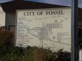
After that, I pondered what I wanted to do for the rest of the day, and figured the answer was "continue driving through very attractive scenery." So, having stopped for coffee, I made my way northeast across Wheeler County and then north to the charming little town of Condon, and from there five or six miles west to this hashpoint.
The point was basically at the entrance to these folks' driveway, so to avoid troubling them I didn't do the precision thing and get out of the car and take a dozen selfies with the hashscot and all that. Instead, I pulled over from the intersection and "consulted the map." Then, I took a few quick pictures, and made to go -- but before I got into gear, someone passing on the highway slowed to a stop to make sure I hadn't out of gas. "Nope," I said. "I'm doing great."
Photos
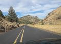
It was a very pleasant drive...
through remote and attractive places...
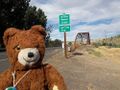
with only a few little towns along the way.
The town of Condon, from a few miles out, is just a green stripe on the prairie.
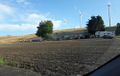
There's the farmhouse; the hashpoint is slightly left of this picture.
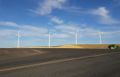
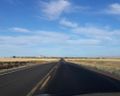
Windmills dominate the view from the hashpoint...
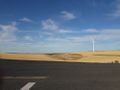
along with miles of wheatlands and open sky.


