Difference between revisions of "2019-12-16 52 12"
From Geohashing
(new report) |
m (Location) |
||
| (2 intermediate revisions by one other user not shown) | |||
| Line 1: | Line 1: | ||
| − | + | {{meetup graticule | |
| − | |||
| − | |||
| − | |||
| − | |||
| − | |||
| − | |||
| − | |||
| − | |||
| lat={{#explode:{{SUBPAGENAME}}| |1}} | | lat={{#explode:{{SUBPAGENAME}}| |1}} | ||
| lon={{#explode:{{SUBPAGENAME}}| |2}} | | lon={{#explode:{{SUBPAGENAME}}| |2}} | ||
| date={{#explode:{{SUBPAGENAME}}| |0}} | | date={{#explode:{{SUBPAGENAME}}| |0}} | ||
| − | }} | + | }} |
| + | |||
__NOTOC__ | __NOTOC__ | ||
== Location == | == Location == | ||
| − | + | ||
| + | The hash lay on the bivouac place at the river Havel at Mögelin. | ||
== Participants == | == Participants == | ||
| − | + | ||
| − | + | [[User:GeorgDerReisende|GeorgDerReisende]] | |
== Plans == | == Plans == | ||
| − | + | ||
| + | Travel and walk. | ||
== Expedition == | == Expedition == | ||
| − | + | ||
| + | It was the usual way. A long travel, a long walk, a long travel. | ||
== Tracklog == | == Tracklog == | ||
| − | + | ||
| + | {{tracklog | 2019-12-16 52 12 GeorgDerReisende.gpx }} | ||
| + | |||
| + | I created this tracklog with https://www.gpsvisualizer.com/draw/?api=google . | ||
| + | |||
| + | During the [[Dark Ages]] I logged all expeditions by contributing to [https://commons.wikimedia.org/wiki/User:GeorgDerReisende/geohashing Wikimedia Commons]. View all photos of this expedition [https://commons.wikimedia.org/wiki/Category:Files_by_User:GeorgDerReisende/20191216 here]. | ||
== Photos == | == Photos == | ||
| − | < | + | |
| − | + | <gallery> | |
| − | -- | + | File:2019-12-16 52 12 GeorgDerReisende 9866.jpg | arrived |
| − | + | File:2019-12-16 52 12 GeorgDerReisende 9892.jpg | the bivouac place | |
| + | File:2019-12-16 52 12 GeorgDerReisende 9894.jpg | the hash | ||
| + | File:2019-12-16 52 12 GeorgDerReisende 9896.jpg | looking north | ||
| + | File:2019-12-16 52 12 GeorgDerReisende 9897.jpg | looking east | ||
| + | File:2019-12-16 52 12 GeorgDerReisende 9898a.jpg | looking south | ||
| + | File:2019-12-16 52 12 GeorgDerReisende 9899.jpg | looking west | ||
| + | File:2019-12-16 52 12 GeorgDerReisende 9900.jpg | the geohasher | ||
</gallery> | </gallery> | ||
| Line 40: | Line 47: | ||
<!-- Add any achievement ribbons you earned below, or remove this section --> | <!-- Add any achievement ribbons you earned below, or remove this section --> | ||
| − | + | {{Dark Ages | latitude = 52 | longitude = 12 | date = 2019-12-16 | name = GeorgDerReisende }} | |
| − | |||
| − | |||
| − | + | {{Minesweeper geohash | graticule = Halle (Saale), Germany | ranknumber = 7 | n = true | ne = true | e = true | s = true | sw = true | w = true | nw = true | name = GeorgDerReisende }} | |
| − | + | {{Minesweeper geohash | graticule = Magdeburg, Germany | ranknumber = 6 | e = true | se = true | s = true | sw = true | w = true | nw = true | name = GeorgDerReisende }} | |
| − | |||
| − | |||
| − | |||
| − | + | {{Minesweeper geohash | graticule = Leipzig, Germany | ranknumber = 5 | n = true | ne = true | sw = true | w = true | nw = true | name = GeorgDerReisende }} | |
| + | |||
| + | {{Minesweeper geohash | graticule = Brandenburg, Germany | ranknumber = 4 | e = true | s = true | sw = true | w = true | name = GeorgDerReisende }} | ||
| + | |||
| + | {{Minesweeper geohash | graticule = Berlin, Germany | ranknumber = 2 | sw = true | w = true | name = GeorgDerReisende }} | ||
| − | |||
[[Category:Expeditions]] | [[Category:Expeditions]] | ||
| − | + | ||
[[Category:Expeditions with photos]] | [[Category:Expeditions with photos]] | ||
| − | + | ||
[[Category:Expedition without GPS]] | [[Category:Expedition without GPS]] | ||
| − | + | ||
| − | |||
| − | |||
[[Category:Coordinates reached]] | [[Category:Coordinates reached]] | ||
| − | + | {{location|DE|BB|HVL}} | |
| − | |||
| − | |||
| − | |||
| − | |||
| − | |||
| − | |||
| − | |||
| − | |||
| − | |||
| − | |||
| − | |||
| − | |||
| − | |||
| − | |||
| − | |||
| − | |||
| − | |||
Latest revision as of 09:42, 4 June 2020
| Mon 16 Dec 2019 in 52,12: 52.5550797, 12.3198754 geohashing.info google osm bing/os kml crox |
Location
The hash lay on the bivouac place at the river Havel at Mögelin.
Participants
Plans
Travel and walk.
Expedition
It was the usual way. A long travel, a long walk, a long travel.
Tracklog
I created this tracklog with https://www.gpsvisualizer.com/draw/?api=google .
During the Dark Ages I logged all expeditions by contributing to Wikimedia Commons. View all photos of this expedition here.
Photos
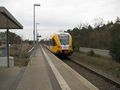
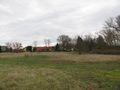
arrived
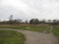
the bivouac place
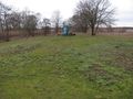
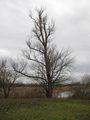
the hash
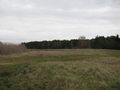
looking north
looking east
looking south
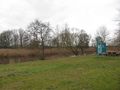
looking west
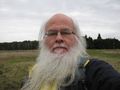
the geohasher


Achievements

GeorgDerReisende earned the Dark Ages achievement
by going on an expedition to the (52, 12) geohash on 2019-12-16.
GeorgDerReisende achieved level 7 of the Minesweeper Geohash achievement
|
GeorgDerReisende achieved level 6 of the Minesweeper Geohash achievement
|
GeorgDerReisende achieved level 5 of the Minesweeper Geohash achievement
|
GeorgDerReisende achieved level 4 of the Minesweeper Geohash achievement
|
GeorgDerReisende achieved level 2 of the Minesweeper Geohash achievement
|