Difference between revisions of "2019-12-29 51 9"
From Geohashing
m (Location) |
m |
||
| Line 41: | Line 41: | ||
{{Dark Ages | latitude = 51 | longitude = 9 | date = 2019-12-29 | name = GeorgDerReisende }} | {{Dark Ages | latitude = 51 | longitude = 9 | date = 2019-12-29 | name = GeorgDerReisende }} | ||
| + | [[Category:Expeditions]] | ||
| + | [[Category:Expeditions with photos]] | ||
[[Category:Coordinates not reached]] | [[Category:Coordinates not reached]] | ||
| − | |||
[[Category:Not reached - Mother Nature]] | [[Category:Not reached - Mother Nature]] | ||
{{location|DE|HE|KS}} | {{location|DE|HE|KS}} | ||
Latest revision as of 13:44, 23 September 2021
| Sun 29 Dec 2019 in 51,9: 51.3896123, 9.4890554 geohashing.info google osm bing/os kml crox |
Location
The hash lay at the edge of a field at the Niederer Gerstenkopfsweg in Hohenkirchen.
Participants
Plans
Traveling to Espenau by regiotram and a walk.
Expedition
I took the regiotram to Mönchehof and started to walk and walked south around Hohenkirchen to the hash. I found it on a field, but with a ditch, a dam and another ditch between the fieldway and the field. And young plants on the field. And didn't go there.
Tracklog
During the Dark Ages I logged all expeditions by contributing to Wikimedia Commons. View all photos of this expedition here.
Photos
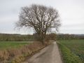
big view
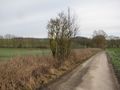
small view
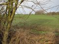
the hash on the field
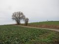
big view, small view and the field


Achievements

GeorgDerReisende earned the Dark Ages achievement
by going on an expedition to the (51, 9) geohash on 2019-12-29.