Difference between revisions of "2020-01-09 33 -13"
m (→Location) |
m (per Renaming Proposal) |
||
| (9 intermediate revisions by 2 users not shown) | |||
| Line 19: | Line 19: | ||
== Expedition == | == Expedition == | ||
| + | Yea!!! The wiki is mended and served over https. Well done. I'll buy you a beer if I ever get the chance! | ||
| + | |||
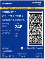
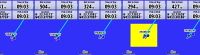
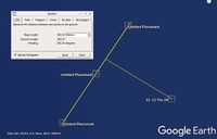
| + | Sourcerer flew from London Stansted to Tenerife South airport for a four week visit to the island. By chance the flight passed under 10 arc seconds from this hashpoint. This is more fun than watching the low resolution flight progress screen (Ryanair doesn't even have these screens). My Garmin device logged me 294 metres from the HP. Google earth said 302 metres. 10 arc seconds is 310 metres so this was a close thing. | ||
== Photos == | == Photos == | ||
<gallery caption="Gallery" widths="200px" heights="200px" perrow="3"> | <gallery caption="Gallery" widths="200px" heights="200px" perrow="3"> | ||
| + | Image:2020-01-09_33_-13_Flight_Sourcerer.jpg | Proof of Flight | ||
Image:2020-01-09 33 -13 Proof Sourcerer.jpg | Proof | Image:2020-01-09 33 -13 Proof Sourcerer.jpg | Proof | ||
Image:2020-01-09 33 -13 Google Sourcerer.jpg | Google Earth | Image:2020-01-09 33 -13 Google Sourcerer.jpg | Google Earth | ||
| Line 31: | Line 35: | ||
| prev = 2019-07-14_52 1 | | prev = 2019-07-14_52 1 | ||
| curr = 2020-01-09_33_-13 | | curr = 2020-01-09_33_-13 | ||
| − | | next = | + | | next = 2021-11-29_52 1 |
| date = 2020-01-09 | | date = 2020-01-09 | ||
}} | }} | ||
| + | |||
| + | {{air geohash | ||
| + | | latitude = 33 | ||
| + | | longitude = -13 | ||
| + | | date = 2020-01-09 | ||
| + | | name = Sourcerer | ||
| + | | vehicle = 737 800 | ||
| + | | subcategory = passenger | ||
| + | }} | ||
| + | {{Graticule unlocked | ||
| + | | latitude = 33 | ||
| + | | longitude = -13 | ||
| + | | date = 2020-01-09 | ||
| + | | name = Sourcerer | ||
| + | }} | ||
| + | {{Dark Ages|date=2020-01-09|latitude=33|longitude=-13|name=[[User:Sourcerer|Sourcerer]]}} | ||
[[Category:Expeditions]] | [[Category:Expeditions]] | ||
[[Category:Expeditions with photos]] | [[Category:Expeditions with photos]] | ||
[[Category:Coordinates reached]] | [[Category:Coordinates reached]] | ||
| + | {{location|XI}} | ||
Latest revision as of 04:49, 20 March 2024
| Thu 9 Jan 2020 in 33,-13: 33.7372300, -13.3772246 geohashing.info google osm bing/os kml crox |
Location
An ocean hashpoint about 340 km east of Funchal, Madeira, Atlantic Ocean.
Planning
Long distance flight boredom - see if we overfly a hashpoint.
Participants
Expedition
Yea!!! The wiki is mended and served over https. Well done. I'll buy you a beer if I ever get the chance!
Sourcerer flew from London Stansted to Tenerife South airport for a four week visit to the island. By chance the flight passed under 10 arc seconds from this hashpoint. This is more fun than watching the low resolution flight progress screen (Ryanair doesn't even have these screens). My Garmin device logged me 294 metres from the HP. Google earth said 302 metres. 10 arc seconds is 310 metres so this was a close thing.
Photos
- Gallery
Proof of Flight
Proof
Google Earth


Achievements
Expeditions and Plans
| 2020-01-09 | ||
|---|---|---|
| Atlantic Ocean 33, -13, Atlantic Ocean | Sourcerer | An ocean hashpoint about 340 km east of Funchal, Madeira, Atlantic Ocean. |
Sourcerer's Expedition Links
2019-07-14_52 1 - 2020-01-09_33_-13 - 2021-11-29_52 1 - KML file download of Sourcerer's expeditions for use with Google Earth.
Sourcerer earned the Air geohash achievement
|
Sourcerer earned the Graticule Unlocked Achievement
|
