Difference between revisions of "2020-02-28 52 -1"
(expedition plans) |
m (Location) |
||
| (11 intermediate revisions by one other user not shown) | |||
| Line 18: | Line 18: | ||
== Participants == | == Participants == | ||
* [[User:KarMann|KarMann]] | * [[User:KarMann|KarMann]] | ||
| + | * KarMann's wife | ||
== Plans == | == Plans == | ||
| Line 24: | Line 25: | ||
== Expedition == | == Expedition == | ||
<!-- how it all turned out. your narrative goes here. --> | <!-- how it all turned out. your narrative goes here. --> | ||
| + | We drove down from [[2020-02-28 53 -1|our failure in the Peak District]] to Birmingham with hopes of greater success to come. KarMann changed into his formal wear along the way, almost achieving an ''en route'' [[geoflashing]]. As we approached, KarMann's wife practised a bit of taking pictures of the dashboard display. After driving through the nearby roundabout, we made our first pass through the hashpoint. It was rather darker by then, so the picture was pretty miserable. We went around for two more passes, getting somewhat better pictures this time. Then we found a side street good for parking, and got out to savour the hashpoint at a more casual pace, despite a slight drizzle. | ||
| + | |||
| + | We found the more precise hashpoint and got as close as we could to what might be its actual location without getting actually onto the road, which was fairly busy. This was KarMann's wife's first successful geohash, so we celebrated with goofy grins, but without our new [[hashscot]] we'd just decided on and brought along, so no pictures with him. He was along for the ride, though, so at least he did make it to the hashpoint. We made one more pass in the car for good measure afterwards, hoping for another shot at a better picture, but, well, you can see how well that worked. | ||
| + | |||
| + | Having gotten the coordinates for the rest of the weekend's hashpoints that afternoon, we had decided on a destination in southwestern Wales in preparation for [[Leap geohash achievement|Leap Day adventures]], so drove on to Fishguard to spend the night there before an early start to get some more expeditions in on that glorious day, starting [[2020-02-29 52 -4|near Cardigan]]. | ||
== Tracklog == | == Tracklog == | ||
<!-- if your GPS device keeps a log, you may post a link here --> | <!-- if your GPS device keeps a log, you may post a link here --> | ||
| + | [https://www.wikiloc.com/car-trails/2020-02-28-52-1-47405344 On WikiLoc] | ||
== Photos == | == Photos == | ||
| Line 33: | Line 40: | ||
--> | --> | ||
<gallery perrow="5"> | <gallery perrow="5"> | ||
| + | Image:2020-02-28 52 -1 Coordinates.jpg | One of the speed racing photos with the GPS metadata closest to the hashpoint. Speed of 31 MPH is somewhat visible. | ||
| + | Image:2020-02-28 52 -1 Map screen.png | The Geohashing app map screen from the pavement | ||
| + | Image:2020-02-28 52 -1 Details.png | The Geohashing app details screen from the pavement | ||
| + | Image:2020-02-28 52 -1 Formal.jpg | [[User:KarMann|KarMann]] in his Friday finest, pointing at the hashpoint in the road. | ||
| + | Image:2020-02-28 52 -1 Goofy grins.jpg | Our goofy grins at the hashpoint. | ||
</gallery> | </gallery> | ||
| Line 38: | Line 50: | ||
{{#vardefine:ribbonwidth|800px}} | {{#vardefine:ribbonwidth|800px}} | ||
<!-- Add any achievement ribbons you earned below, or remove this section --> | <!-- Add any achievement ribbons you earned below, or remove this section --> | ||
| + | {{land geohash | ||
| + | | latitude = 53 | ||
| + | | longitude = -1 | ||
| + | | date = 2020-02-28 | ||
| + | | name = [[User:KarMann|KarMann]] & KarMann's wife | ||
| + | <!-- | image = --> | ||
| + | }} | ||
| + | {{drag-along | ||
| + | | latitude = 52 | ||
| + | | longitude = -1 | ||
| + | | date = 2020-02-28 | ||
| + | | partner = KarMann's wife | ||
| + | | name = [[User:KarMann|KarMann]] | ||
| + | | image = 2020-02-28 52 -1 Goofy grins.jpg | ||
| + | }} | ||
| + | {{Speed racer | ||
| + | | latitude = 52 | ||
| + | | longitude = -1 | ||
| + | | date = 2020-02-28 | ||
| + | | name = [[User:KarMann|KarMann]] | ||
| + | | image = 2020-02-28 52 -1 Coordinates.jpg | ||
| + | | speed = 30 MPH | ||
| + | }} | ||
| + | {{Minesweeper geohash | ||
| + | | graticule = Manchester, United Kingdom | ||
| + | | ranknumber = 1 | ||
| + | | se = true | ||
| + | | name = [[User:KarMann|KarMann]] | ||
| + | }} | ||
| + | {{Formal attire | ||
| + | | latitude = 52 | ||
| + | | longitude = -1 | ||
| + | | date = 2020-02-28 | ||
| + | | name = [[User:KarMann|KarMann]] | ||
| + | | image = 2020-02-28 52 -1 Formal.jpg | ||
| + | }} | ||
<!-- =============== USEFUL CATEGORIES FOLLOW ================ | <!-- =============== USEFUL CATEGORIES FOLLOW ================ | ||
Delete the next line ONLY if you have chosen the appropriate categories below. If you are unsure, don't worry. People will read your report and help you with the classification. --> | Delete the next line ONLY if you have chosen the appropriate categories below. If you are unsure, don't worry. People will read your report and help you with the classification. --> | ||
| − | |||
| − | |||
| − | |||
| − | |||
| − | |||
| − | |||
| − | |||
| − | |||
| − | |||
| − | |||
| − | |||
| − | |||
[[Category:Expeditions]] | [[Category:Expeditions]] | ||
| − | |||
[[Category:Expeditions with photos]] | [[Category:Expeditions with photos]] | ||
| − | |||
| − | |||
| − | |||
| − | |||
| − | |||
[[Category:Coordinates reached]] | [[Category:Coordinates reached]] | ||
| − | + | {{location|GB|ENG|SOL}} | |
| − | |||
| − | |||
| − | |||
| − | |||
| − | |||
| − | |||
| − | |||
| − | |||
| − | |||
| − | |||
| − | |||
| − | |||
| − | |||
| − | |||
| − | |||
| − | |||
| − | |||
Latest revision as of 05:02, 1 April 2020
| Fri 28 Feb 2020 in 52,-1: 52.4050773, -1.7840553 geohashing.info google osm bing/os kml crox |
Location
The hashpoint is right on the east side of Monkspath Hall Road in Solihull, southeast of Birmingham.
Participants
- KarMann
- KarMann's wife
Plans
KarMann will drive through at speed and get a Speed racer achievement, preferably southbound for greatest accuracy.
Expedition
We drove down from our failure in the Peak District to Birmingham with hopes of greater success to come. KarMann changed into his formal wear along the way, almost achieving an en route geoflashing. As we approached, KarMann's wife practised a bit of taking pictures of the dashboard display. After driving through the nearby roundabout, we made our first pass through the hashpoint. It was rather darker by then, so the picture was pretty miserable. We went around for two more passes, getting somewhat better pictures this time. Then we found a side street good for parking, and got out to savour the hashpoint at a more casual pace, despite a slight drizzle.
We found the more precise hashpoint and got as close as we could to what might be its actual location without getting actually onto the road, which was fairly busy. This was KarMann's wife's first successful geohash, so we celebrated with goofy grins, but without our new hashscot we'd just decided on and brought along, so no pictures with him. He was along for the ride, though, so at least he did make it to the hashpoint. We made one more pass in the car for good measure afterwards, hoping for another shot at a better picture, but, well, you can see how well that worked.
Having gotten the coordinates for the rest of the weekend's hashpoints that afternoon, we had decided on a destination in southwestern Wales in preparation for Leap Day adventures, so drove on to Fishguard to spend the night there before an early start to get some more expeditions in on that glorious day, starting near Cardigan.
Tracklog
Photos

One of the speed racing photos with the GPS metadata closest to the hashpoint. Speed of 31 MPH is somewhat visible.
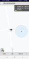
The Geohashing app map screen from the pavement
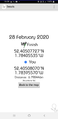
The Geohashing app details screen from the pavement

KarMann in his Friday finest, pointing at the hashpoint in the road.

Our goofy grins at the hashpoint.


Achievements
KarMann & KarMann's wife earned the Land geohash achievement
|
KarMann earned the Drag-along achievement
|

KarMann achieved level 1 of the Minesweeper Geohash achievement
|
KarMann earned the Formal attire achievement
|