Difference between revisions of "2020-03-11 50 -1"
Macronencer (talk | contribs) (→Photos: Add gallery photos) |
m (Location) |
||
| (2 intermediate revisions by one other user not shown) | |||
| Line 1: | Line 1: | ||
| − | + | [[Image:{{{image|2020-03-11 50 -1 Macronencer 08 Another Bridge.jpg}}}|thumb|left]] | |
| − | + | {{meetup graticule | |
| − | |||
| − | |||
| − | |||
| − | |||
| − | |||
| − | |||
| lat=50 | | lat=50 | ||
| lon=-1 | | lon=-1 | ||
| date=2020-03-11 | | date=2020-03-11 | ||
}}<!-- edit as necessary --> | }}<!-- edit as necessary --> | ||
| − | + | ||
== Location == | == Location == | ||
Burley, New Forest, [[Southampton, United Kingdom]] | Burley, New Forest, [[Southampton, United Kingdom]] | ||
| Line 96: | Line 90: | ||
<!-- Add any achievement ribbons you earned below, or remove this section --> | <!-- Add any achievement ribbons you earned below, or remove this section --> | ||
| − | + | {{There might be alligators!|latitude=50|longitude=-1|date=2020-03-11|name=[[User:Macronencer|Macronencer]]|hazard=near-perfect simulacrum of Tolkien's Dead Marshes|image=2020-03-11 50 -1 Macronencer 09 Trying Other Routes.jpg}} | |
| − | |||
| − | [[ | ||
| − | |||
| − | |||
| − | |||
| − | |||
| − | |||
[[Category:Expeditions]] | [[Category:Expeditions]] | ||
| − | |||
[[Category:Expeditions with photos]] | [[Category:Expeditions with photos]] | ||
| − | |||
| − | |||
| − | |||
| − | |||
| − | |||
| − | |||
| − | |||
| − | |||
| − | |||
[[Category:Coordinates not reached]] | [[Category:Coordinates not reached]] | ||
| − | |||
| − | |||
[[Category:Not reached - Mother Nature]] | [[Category:Not reached - Mother Nature]] | ||
| − | + | {{location|GB|ENG|HAM}} | |
| − | |||
| − | |||
| − | |||
| − | |||
| − | |||
| − | |||
| − | |||
| − | |||
| − | |||
| − | |||
Latest revision as of 03:42, 12 March 2020

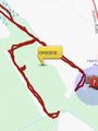
| Wed 11 Mar 2020 in 50,-1: 50.8065775, -1.6770074 geohashing.info google osm bing/os kml crox |
Contents
Location
Burley, New Forest, Southampton, United Kingdom
Participants
Plans
Macronencer (talk) plans to go, probably mid-morning as the weather looks best then.
Expedition
Smeagol’s journey
Sit, hobbits! Sit! We is going to tells you all abouts our quest for the Precious, oh yesss. First, we hitches a ride. We stows away, we does, on a cart. Gollum! And the cart stops at an old travelling place, very old, very ancient, and full of elveses eating horrid things like cakeses and bunses and cups of tea. Yuck! They wasn’t selling any juicy sweet fishies my dear, oh no my precious, no.
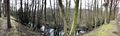
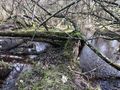
We knows where the precious is hiding, hobbitses, oh yes we does. And we quickly goes up, up, up the path to find it. But it doesn’t look very nice, no it doesn’t. It looks all swampy and squidgy and full of orcses and maybe alligators too. And so we runs ahead quickly to see if we can find a way through. And we runs all around a big forest, all around the edge. And the other side looks all right, yes it does, it looks fine, all dry and easy. But it wasn’t, precious, oh no, no, no. Gollum! It was TRICKSY and WET. And we tried to cross it, we tried and tried, but it wasn’t like the Dead Marshes at all. We didn’t know the way. We forgot. And we tried to go another way round, by a little brook, even though there was a bridge and there could have been trollses hiding there, because trollses likes to hide under bridges. But we had to try, we had to! And the precious was still too far to reach, and we ran back around the woods, and there were people there. Elves and Men, and little hobbits riding on wheels and poking sticks into things. And Smeagol doesn’t like being poked, so he ran, he ran all the way out of the wood.
And we still doesn’t have the precious! And tomorrow it will disappear and appear somewhere else, and Smeagol doesn’t know where! And all there was to eat was horrid taters and leekies and cockasoup. Gollum!
Macronencer’s journey
Oddly enough, my experience was very similar to Smeagol’s. I had no idea the rascal had been there before me, though obviously he’d long gone when I arrived… unless he was hiding, waiting to ambush me if I reached the Precious, that is.
I parked at the Old Station Tea Rooms, which is a nice little place with a great menu and good service. And I set off in high spirits, expecting at least to get close to the hash point.

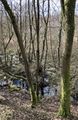
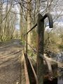
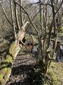
As soon as I looked to my left after crossing a small bridge, my heart sank. The place was a mangrove swamp! In the vain hope that parts of it might still be dry, I continued, trying to see how close I could get. It turned out that the answer was 77m. Bascially, this was the path of the railway that used to run through here (you can see the remains of the station platform), and I was on an embankment. Further down there was a track below me, leading to the left. I took it, hoping to circle round and find a drier way in. Some parts of the forest floor looked as if I could walk on them. I tried a few times, but each time I ended up almost surrounded by not just mud but an actual pond. As Smeagol said... just like the Dead Marshes. Eventually I found a stream that ran back towards where I’d started, and the banks on each side of it were quite high off the ground. Thinking I might be able to get closer that way, I started walking along the left one. The first obstacle was a fallen tree, and I’m proud to say I managed to climb over it. The second was another fallen tree, but this time there was swamp under it, and my boots were not up to the job. I really must get some waders...

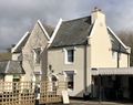
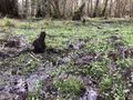
Admiting defeat, I turned back, and spent half an hour wandering up the original track and back. I found a very interesting-looking house, and also an artificial flower lying on the ground – a buttonhole, I think. Perhaps from somebody’s formal attire geohash? I picked it up to take home and throw away.
After rounding off the morning with a nice lunch of tomato soup and green tea (I recommend the Tea Rooms highly, very good!) I hit the road and returned home to write my report.
Thankfully, I hadn’t encountered a single nazgul.
Tracklog
Photos
Yes, it literally is an old station. Nice place.
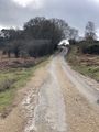
Here we go!
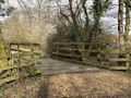
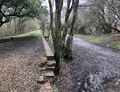
A footbridge marks the start of this trail.
Oh dear, that doesn't look dry.

This was as close as I would ever get, sadly.
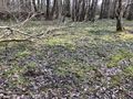
The hash point is in there somewhere.
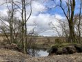
On the right hand side of the track, it was all open land!
A typical railway bridge with iron railings.
Trying to get in from the other side.
It looks like mud, but it's deeper than you think!
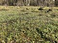
You could probably breed frogs in here. Or maybe some trout.
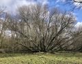
This magnificent tree.
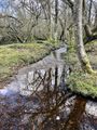
Could I maybe walk along that left bank and reach the hash?
OK, so this is the sort of thing I can expect for the next 250m then. Astonishingly, I did actually get past this one...
...only to fail to get past this one.

Artificial buttonhole flower. Kind of an odd thing to find here!
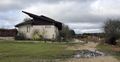
I'd like to meet the architect of this place.
You can still see the old rails in the ground.
When I'm fitter, I'll come back and cycle this route!
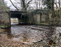
Bridge that might harbour trolls.
The raised part on the left seems to be the original station platform.
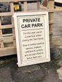
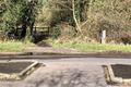
No parking sign. I spoke to the staff and they said it was fine. Probably because it's out of season - the New Forest is insanely busy in the Summer!
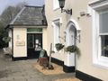
Tea Rooms.
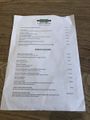
Menu.

This tomato soup was really good!
I think this shows admirable persistence.

Giving Dash a much-needed wash. It's been a long time!

This one's for all those people who ask "can you wash electric cars?" Hint: I'm not currently (haha) dead from electrocution.

FINALLY! I needed this coffee.


Achievements
Macronencer earned the There might be alligators! consolation prize
|