Difference between revisions of "2020-05-16 47 -122"
([live picture]Just managed to escape the rain [https://openstreetmap.org/?lat=47.68173320&lon=-122.40385190&zoom=16&layers=B000FTF @47.6817,-122.4039]) |
m (Location correction) |
||
| (6 intermediate revisions by 2 users not shown) | |||
| Line 21: | Line 21: | ||
== Expedition == | == Expedition == | ||
| − | |||
| + | === Thomcat === | ||
| + | Did other things - hey, it's Saturday - and also got rained on a bit. Looked up at 10 to 4 and said "Hey, time for Geohashing!" | ||
| + | |||
| + | This is a short drive from my house, mostly downhill: | ||
*Running a few minutes late, but it's all downhill from here! -- [[User:Thomcat|Thomcat]] ([[User talk:Thomcat|talk]]) [https://openstreetmap.org/?lat=47.69063930&lon=-122.38947620&zoom=16&layers=B000FTF @47.6906,-122.3895] 16:03, 16 May 2020 (PDT) | *Running a few minutes late, but it's all downhill from here! -- [[User:Thomcat|Thomcat]] ([[User talk:Thomcat|talk]]) [https://openstreetmap.org/?lat=47.69063930&lon=-122.38947620&zoom=16&layers=B000FTF @47.6906,-122.3895] 16:03, 16 May 2020 (PDT) | ||
| − | == | + | |
| − | + | I only saw one entrance into the parking lot that wasn't coned off - but plenty of street parking right next to the spot. I parked on the street, grabbed pink chalk (a darker color might have been better), and paced the spot. Not sure if the giant metal doors threw off the GPS, but it did settle at less than a meter at one point - and the location matches the aerial google maps view. | |
| + | |||
| + | Chalked, selfy, and took a few other pictures of the area - then off to stand in line to get into Trader Joe's. Saturday success! | ||
| + | |||
| + | === Coyotebush === | ||
| + | Had a nice rainy Saturday indoors. Put some more air in the bike tires and started watching the weather radar. Probably could have made it for 4:00 without getting too wet, but similarly lost track of time. | ||
| + | *Heading out. -- [[User:Coyotebush|Coyotebush]] ([[User talk:Coyotebush|talk]]) 17:45, 16 May 2020 (PDT) | ||
| + | |||
| + | I frequently pass by here on bike rides for exercise. Used to cross the locks and then head north, but now that the locks are closed to visitors I take neighborhood streets through Ballard. Easy enough on a bike to weave through the parking lot looking for those storage structures. | ||
| + | |||
| + | I likewise had trouble getting the GPS reading to align with the satellite image. There were enough people hanging around the parking lot that I didn't linger to upload photos on site. | ||
| + | |||
| + | Continued north to take the climb up Golden Gardens Drive and looped around back home - just as it began to sprinkle again. | ||
== Photos == | == Photos == | ||
| Line 43: | Line 58: | ||
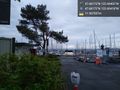
Image:2020-05-16_47_-122_thomcat_1589671280692.jpg|Just managed to escape the rain [https://openstreetmap.org/?lat=47.68173320&lon=-122.40385190&zoom=16&layers=B000FTF @47.6817,-122.4039] | Image:2020-05-16_47_-122_thomcat_1589671280692.jpg|Just managed to escape the rain [https://openstreetmap.org/?lat=47.68173320&lon=-122.40385190&zoom=16&layers=B000FTF @47.6817,-122.4039] | ||
| + | |||
| + | Image:2020-05-16_47_-122_coyotebush_1589685187377.jpg|On the spot | ||
| + | |||
| + | Image:2020-05-16_47_-122_coyotebush_1589685223973.jpg|Found Thom's mark | ||
| + | |||
| + | Image:2020-05-16_47_-122_coyotebush_1589685572997.jpg|Sky cleared up a little | ||
</gallery> | </gallery> | ||
== Achievements == | == Achievements == | ||
{{#vardefine:ribbonwidth|800px}} | {{#vardefine:ribbonwidth|800px}} | ||
| − | + | {{Bicycle geohash | latitude = 47 | longitude = -122 | date = 2020-05-16 | name = coyotebush }} | |
| − | |||
| − | {{ | ||
| − | | latitude = 47 | ||
| − | | longitude = -122 | ||
| − | | date = | ||
| − | |||
| − | | name = | ||
| − | |||
| − | }} | ||
| − | |||
| − | |||
| − | |||
| − | |||
[[Category:Expeditions]] | [[Category:Expeditions]] | ||
[[Category:Expeditions with photos]] | [[Category:Expeditions with photos]] | ||
[[Category:Coordinates reached]] | [[Category:Coordinates reached]] | ||
| − | + | {{location|US|WA|KN}} | |
| − | |||
| − | |||
| − | |||
| − | |||
| − | |||
| − | |||
| − | |||
| − | |||
| − | |||
| − | |||
| − | {{location|US|WA| | ||
Latest revision as of 20:24, 22 May 2020
| Sat 16 May 2020 in Seattle: 47.6817281, -122.4040167 geohashing.info google osm bing/os kml crox |
Location
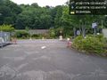
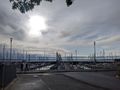
Public parking area at Shilshole Bay Marina.
Participants
Plans
High chance of rain, but plan to be there at 4:00.
- I might wait until later - looks like there may be a break in the rain between roughly 5 and 7. Will look for your chalk mark :) Coyotebush (talk) 21:05, 16 May 2020 (UTC)
Expedition
Thomcat
Did other things - hey, it's Saturday - and also got rained on a bit. Looked up at 10 to 4 and said "Hey, time for Geohashing!"
This is a short drive from my house, mostly downhill:
- Running a few minutes late, but it's all downhill from here! -- Thomcat (talk) @47.6906,-122.3895 16:03, 16 May 2020 (PDT)
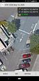
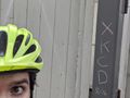
I only saw one entrance into the parking lot that wasn't coned off - but plenty of street parking right next to the spot. I parked on the street, grabbed pink chalk (a darker color might have been better), and paced the spot. Not sure if the giant metal doors threw off the GPS, but it did settle at less than a meter at one point - and the location matches the aerial google maps view.
Chalked, selfy, and took a few other pictures of the area - then off to stand in line to get into Trader Joe's. Saturday success!
Coyotebush
Had a nice rainy Saturday indoors. Put some more air in the bike tires and started watching the weather radar. Probably could have made it for 4:00 without getting too wet, but similarly lost track of time.
- Heading out. -- Coyotebush (talk) 17:45, 16 May 2020 (PDT)
I frequently pass by here on bike rides for exercise. Used to cross the locks and then head north, but now that the locks are closed to visitors I take neighborhood streets through Ballard. Easy enough on a bike to weave through the parking lot looking for those storage structures.
I likewise had trouble getting the GPS reading to align with the satellite image. There were enough people hanging around the parking lot that I didn't linger to upload photos on site.
Continued north to take the climb up Golden Gardens Drive and looped around back home - just as it began to sprinkle again.
Photos

geohasher @47.6817,-122.4040
Shilshole marins @47.6817,-122.4042
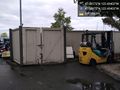
storage structures @47.6817,-122.4040
Controlled access @47.6819,-122.4042
Just managed to escape the rain @47.6817,-122.4039
On the spot
Found Thom's mark
Sky cleared up a little


Achievements
coyotebush earned the Bicycle geohash achievement
|