Difference between revisions of "2020-08-20 47 7"
m (→Achievements: Update bicycle distance) |
|||
| (8 intermediate revisions by the same user not shown) | |||
| Line 5: | Line 5: | ||
}} | }} | ||
== Location == | == Location == | ||
| − | Near Thierenbach, in Soultz-Haut-Rhin. | + | Near Thierenbach, in [[wikipedia:Soultz-Haut-Rhin|Soultz-Haut-Rhin]]. |
== Participants == | == Participants == | ||
| − | [[User:Baarde|Baarde]] | + | * [[User:Baarde|Baarde]] |
== Plans == | == Plans == | ||
| Line 14: | Line 14: | ||
== Expedition == | == Expedition == | ||
| − | I left home with my bicycle before noon and headed towards Ribeauvillé. I took the same route as for [[2020-08-17 48 7|my previous expedition]] until Kientzheim. I followed the EuroVelo 5 until Turckheim and climbed to the Hohlandsbourg castle before descending to Gueberschwihr. | + | I left home with my bicycle before noon and headed towards Ribeauvillé. I took the same route as for [[2020-08-17 48 7|my previous expedition]] until Kientzheim. There I followed the EuroVelo 5 until Turckheim and climbed to the Hohlandsbourg castle before descending to Gueberschwihr. |
| − | After cycling 50 km and climbing | + | After cycling 50 km and climbing about 1000 m through the vineyards and forests, I was starting to feel a little bit peckish. I stopped in Rouffach to eat some tapas and a big ice cream, and drink a beer, a lemonade, an apfelschorle and a coffee. I was now ready to get back on my bicycle and attempt to complete the expedition. |
| − | I stayed (most of the time) on the EuroVelo 5 until Soultz-Haut-Rhin and entered the forest. | + | I stayed (most of the time) on the EuroVelo 5 until Soultz-Haut-Rhin and entered the forest. After a couple of kilometers, as the road was crossing a dried-up stream, I left my bicycle behind a tree and went up the stream for about 150 meters before reaching the coordinates. |
| + | |||
| + | On my way back to my bicycle, I found some garbage, which I threw in a trash bin in Bollwiller. Conveniently, not far from the trash bin was a train station. I took a train to Colmar and cycled the remaining 20 km to home. | ||
| + | |||
| + | This is my longest [[Bicycle geohash]] (so far) with 73 km to reach the coordinates and 103 km cycled in total. | ||
== Photos == | == Photos == | ||
| − | <gallery | + | <gallery> |
| + | Image:2020-08-20 47 7 01.jpg | Taking a detour by Soultzmatt | ||
| + | Image:2020-08-20 47 7 02.jpg | Cycling between the vineyards | ||
| + | Image:2020-08-20 47 7 09.jpg | Leaving my bicycle | ||
| + | Image:2020-08-20 47 7 03.jpg | The geohash | ||
| + | Image:2020-08-20 47 7 04.png | Coordinates reached | ||
| + | Image:2020-08-20 47 7 05.jpg | Stupid grin | ||
| + | Image:2020-08-20 47 7 06.jpg | Hello goetrash! | ||
| + | Image:2020-08-20 47 7 07.jpg | Leaving Soultz-Haut-Rhin | ||
| + | Image:2020-08-20 47 7 08.jpg | Bye bye geotrash! | ||
</gallery> | </gallery> | ||
== Achievements == | == Achievements == | ||
| − | {{#vardefine:ribbonwidth| | + | {{#vardefine:ribbonwidth|100%}} |
| + | {{land geohash | ||
| + | | latitude = 47 | ||
| + | | longitude = 7 | ||
| + | | date = 2020-08-20 | ||
| + | | name = [[User:Baarde|Baarde]] | ||
| + | }} | ||
| + | {{bicycle geohash | ||
| + | | latitude = 47 | ||
| + | | longitude = 7 | ||
| + | | date = 2020-08-20 | ||
| + | | name = [[User:Baarde|Baarde]] | ||
| + | | distance = 103 km | ||
| + | | bothways = true | ||
| + | }} | ||
| + | {{Geotrash | ||
| + | | latitude = 47 | ||
| + | | longitude = 7 | ||
| + | | date = 2020-08-20 | ||
| + | | name = [[User:Baarde|Baarde]] | ||
| + | }} | ||
__NOTOC__ | __NOTOC__ | ||
[[Category:Expeditions]] | [[Category:Expeditions]] | ||
| + | [[Category:Expeditions with photos]] | ||
[[Category:Coordinates reached]] | [[Category:Coordinates reached]] | ||
{{location|FR|68}} | {{location|FR|68}} | ||
Latest revision as of 11:20, 16 August 2021
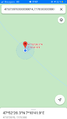
| Thu 20 Aug 2020 in 47,7: 47.8739692, 7.1783004 geohashing.info google osm bing/os kml crox |
Location
Near Thierenbach, in Soultz-Haut-Rhin.
Participants
Plans
The coordinates are 48 km from home by bicycle if I take a direct route through the plain. However I don’t intend to take a direct route through the plain.
Expedition
I left home with my bicycle before noon and headed towards Ribeauvillé. I took the same route as for my previous expedition until Kientzheim. There I followed the EuroVelo 5 until Turckheim and climbed to the Hohlandsbourg castle before descending to Gueberschwihr.
After cycling 50 km and climbing about 1000 m through the vineyards and forests, I was starting to feel a little bit peckish. I stopped in Rouffach to eat some tapas and a big ice cream, and drink a beer, a lemonade, an apfelschorle and a coffee. I was now ready to get back on my bicycle and attempt to complete the expedition.
I stayed (most of the time) on the EuroVelo 5 until Soultz-Haut-Rhin and entered the forest. After a couple of kilometers, as the road was crossing a dried-up stream, I left my bicycle behind a tree and went up the stream for about 150 meters before reaching the coordinates.
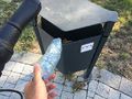
On my way back to my bicycle, I found some garbage, which I threw in a trash bin in Bollwiller. Conveniently, not far from the trash bin was a train station. I took a train to Colmar and cycled the remaining 20 km to home.
This is my longest Bicycle geohash (so far) with 73 km to reach the coordinates and 103 km cycled in total.
Photos
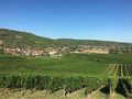
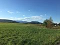
Taking a detour by Soultzmatt
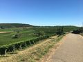
Cycling between the vineyards
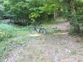
Leaving my bicycle
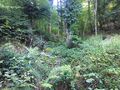
The geohash
Coordinates reached
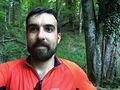
Stupid grin
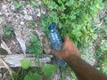
Hello goetrash!
Leaving Soultz-Haut-Rhin
Bye bye geotrash!


Achievements
Baarde earned the Land geohash achievement
|
Baarde earned the Bicycle geohash achievement
|
Baarde earned the GeoTrash Geohash Achievement
|