Difference between revisions of "2020-09-17 35 -105"
(trip report) |
m (dark photos) |
||
| Line 1: | Line 1: | ||
| − | + | {{meetup graticule | |
| − | |||
| − | |||
| − | |||
| − | |||
| − | |||
| − | |||
| − | |||
| − | |||
| lat={{#explode:{{SUBPAGENAME}}| |1}} | | lat={{#explode:{{SUBPAGENAME}}| |1}} | ||
| lon={{#explode:{{SUBPAGENAME}}| |2}} | | lon={{#explode:{{SUBPAGENAME}}| |2}} | ||
| date={{#explode:{{SUBPAGENAME}}| |0}} | | date={{#explode:{{SUBPAGENAME}}| |0}} | ||
| − | }} | + | }} |
| + | |||
__NOTOC__ | __NOTOC__ | ||
== Location == | == Location == | ||
| Line 23: | Line 16: | ||
== Expedition == | == Expedition == | ||
| − | Erik picked up Arlo near his house since one of Arlo's headlights was out. From there it was a short hop over to the interstate and down it a ways until a convenient pullover spot was found near the hash. Erik dispensed headlamps and they used the steps through the Daughters of the American Revolution monument to those killed in the [[wikipedia:Battle of Glorieta Pass]] (which has seen better days) to easily reach the riverbed, which was followed downstream until they realised, squinting into their phones against headlamp glare that they had passed it, so they doubled back to approximate the location as best they could and took celebratory photos at a minute to midnight. They spent some time looking at the colourful graffiti on the concrete bank of the railroad grade, and at some rail paraphernalia that had found a gradual way into the creekbed -- a rail axle, and some rails themselves. We also peeked inside a drainage tunnel under the tracks, and climbed a nearby hill that once had a wooden star lit up with chain-lights, now decrepit. Then discussion about local and global affairs on the trip home. A short and sweet successful expedition. | + | Erik picked up Arlo near his house since one of Arlo's headlights was out. From there it was a short hop over to the interstate and down it a ways until a convenient pullover spot was found near the hash. Erik dispensed headlamps and they used the steps through the Daughters of the American Revolution monument to those killed in the [[wikipedia:Battle of Glorieta Pass#Apache_Canyon]] (which has seen better days) to easily reach the riverbed, which was followed downstream until they realised, squinting into their phones against headlamp glare that they had passed it, so they doubled back to approximate the location as best they could and took celebratory photos at a minute to midnight. They spent some time looking at the colourful graffiti on the concrete bank of the railroad grade, and at some rail paraphernalia that had found a gradual way into the creekbed -- a rail axle, and some rails themselves. We also peeked inside a drainage tunnel under the tracks, and climbed a nearby hill that once had a wooden star lit up with chain-lights, now decrepit. Then discussion about local and global affairs on the trip home. A short and sweet successful expedition. |
== Tracklog == | == Tracklog == | ||
| Line 29: | Line 22: | ||
== Photos == | == Photos == | ||
| − | |||
| − | |||
| − | |||
<gallery perrow="5"> | <gallery perrow="5"> | ||
| + | 2020-09-17 35 -105 graffito.jpg|graffito | ||
| + | 2020-09-17 35 -105 axle.jpg|adventure wheel | ||
| + | 2020-09-17 35 -105 tunnel.jpg|comfy tunnel | ||
</gallery> | </gallery> | ||
| Line 40: | Line 33: | ||
| latitude = 35 | | latitude = 35 | ||
| longitude = -105 | | longitude = -105 | ||
| − | | date = 2020-09-17 | + | | date = 2020-09-17 |
| name = Erik and [[user:Arlo]] | | name = Erik and [[user:Arlo]] | ||
| image = 2020-09-17 35 -105 tunnel.jpg | | image = 2020-09-17 35 -105 tunnel.jpg | ||
}} | }} | ||
| + | {{geotrash | ||
| + | | latitude = 35 | ||
| + | | longitude = -105 | ||
| + | | date = 2020-09-17 | ||
| + | | name = Erik and [[user:Arlo]] | ||
| + | | image = 2020-09-17 35 -105 trashy trash one hundred percent trash.jpg | ||
| + | }} | ||
| − | + | [[category:new report]] | |
| − | + | [[category:expeditions]] | |
| − | [[ | + | [[category:expeditions with photos]] |
| − | + | [[category:coordinates reached]] | |
| − | |||
| − | |||
| − | |||
| − | |||
| − | [[ | ||
| − | |||
| − | |||
| − | |||
| − | |||
| − | |||
| − | |||
| − | |||
| − | |||
| − | [[ | ||
| − | |||
| − | |||
| − | |||
| − | |||
| − | |||
| − | |||
| − | |||
| − | |||
| − | |||
| − | |||
| − | |||
| − | |||
| − | |||
| − | |||
| − | |||
| − | |||
| − | |||
| − | |||
| − | |||
| − | |||
| − | |||
| − | |||
| − | |||
Revision as of 07:55, 18 September 2020
| Thu 17 Sep 2020 in 35,-105: 35.5585138, -105.8113296 geohashing.info google osm bing/os kml crox |
Location
In the streambed of Deer Creek right above where Grasshopper Canyon Creek joins it (and Apache Creek and Apache Canyon creek meet it not much farther downstream to form the Galisteo Creek, which joins up with the Rio Grande many miles later), sandwiched between the AT&SF tracks and Interstate 25 / US 285.
Participants
Erik and user:Arlo both were looking at gh.info earlier in the day...
Plans
...but it took Erik suggesting at an hour to midnight that they meet up with masks to do a midnight hash to actually get it started.
Expedition
Erik picked up Arlo near his house since one of Arlo's headlights was out. From there it was a short hop over to the interstate and down it a ways until a convenient pullover spot was found near the hash. Erik dispensed headlamps and they used the steps through the Daughters of the American Revolution monument to those killed in the wikipedia:Battle of Glorieta Pass#Apache_Canyon (which has seen better days) to easily reach the riverbed, which was followed downstream until they realised, squinting into their phones against headlamp glare that they had passed it, so they doubled back to approximate the location as best they could and took celebratory photos at a minute to midnight. They spent some time looking at the colourful graffiti on the concrete bank of the railroad grade, and at some rail paraphernalia that had found a gradual way into the creekbed -- a rail axle, and some rails themselves. We also peeked inside a drainage tunnel under the tracks, and climbed a nearby hill that once had a wooden star lit up with chain-lights, now decrepit. Then discussion about local and global affairs on the trip home. A short and sweet successful expedition.
Tracklog
a.k.a. osmuser:Arlo\ James\ Barnes/traces/3417450
Photos
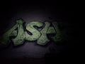
graffito
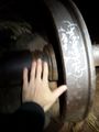
adventure wheel
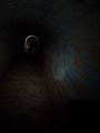
comfy tunnel


Achievements
Erik and user:Arlo earned the Midnight Geohash achievement
|
Erik and user:Arlo earned the GeoTrash Geohash Achievement
|