Difference between revisions of "2020-09-24 49 9"
(An expedition message sent via Geohash Droid for Android.) |
(→Expedition) |
||
| (5 intermediate revisions by 2 users not shown) | |||
| Line 1: | Line 1: | ||
| − | + | {{meetup graticule | |
| − | |||
| − | |||
| − | |||
| − | |||
| − | |||
| − | |||
| − | |||
| − | |||
| lat=49 | | lat=49 | ||
| lon=9 | | lon=9 | ||
| date=2020-09-24 | | date=2020-09-24 | ||
| − | }} | + | }} |
__NOTOC__ | __NOTOC__ | ||
== Location == | == Location == | ||
| − | + | In the woods behind some houses in Karbach. | |
== Participants == | == Participants == | ||
| − | + | * [[User:Rincewind|Rincewind]] | |
| − | + | * [[User:Mampfred|Mampfred]] | |
== Plans == | == Plans == | ||
| − | < | + | <table style="border-width: 1px; border-spacing: 0px; border-style: solid solid solid solid; border-color: lightgray;"> |
| + | <tr> | ||
| + | <td style="border-width: 5px; border-spacing: 2px; border-style: hidden hidden hidden solid; border-color: #8268ed; border-collapse: separate;"></td> | ||
| + | <td style="padding: 0px 12px 0px 10px;">Multihash x 3: [[2020-09-24 49 7|Kaiserslautern]], [[2020-09-24 49 9|Würzburg]], [[2020-09-24 49 8|Darmstadt]]</td> | ||
| + | </tr> | ||
| + | </table> | ||
== Expedition == | == Expedition == | ||
| − | + | * Done with 49 7, on the way to this one in our hash tour -- [[User:Mampfred|Mampfred]] ([[User talk:Mampfred|talk]]) [https://openstreetmap.org/?lat=49.94689140&lon=7.79237870&zoom=16&layers=B000FTF @49.9469,7.7924] 11:17, 24 September 2020 (GMT+02:00) | |
| − | + | Coming from the previous hash, we had a little chat with [[User:GeorgDerReisende|GeorgDerReisende]] via text wether he would make it to the [[49,8]] hash today and if whe would be comfortable to wait for arrival even if it took a couple of more hours. Thankfully he was fine with that so we decided to go to this hash first in order to finish up in Darmstadt where we would meet up and also Mampfred could take the train back home. | |
| − | + | ||
| + | The journey was not very eventful. When we got there, we parked on a steep street in fron of some houses which pretty much were between us and the hash so we had to find our was around them. | ||
| + | |||
| + | On the way we encountered a strangely abused tennis court where somebody had decided that ... we don't know what he decided or what those things are. Golf course greens? Minigolf course greens? Tennis court greens? | ||
| + | |||
| + | Whatever, we found the hash not too far into the woods and since [[User:Rincewind|Rincewind]] forgot his color spray in the car this time we made a classic XKCD sign out of tree branches. | ||
| + | |||
| + | With that, we made our way to the final hash of the day [[2020-09-24 49 8]]. | ||
== Photos == | == Photos == | ||
| − | |||
| − | |||
| − | |||
<gallery perrow="5"> | <gallery perrow="5"> | ||
| + | Image:2020-09-24_49_9_weird_tennis_court_golf_course_hybrid.jpg | Weird tennis court golf course hybrid | ||
| + | Image:2020-09-24_49_9_coordinates_reached.png | Coordinates reached | ||
| + | Image:2020-09-24_49_9_Mampfred_1600946192590.jpg|Hash number two (no offence to our fellow UK hashers) [https://openstreetmap.org/?lat=49.87632590&lon=9.60605880&zoom=16&layers=B000FTF @49.8763,9.6061] | ||
| + | Image:2020-09-24_149_9_xkcd_sign.jpg | Xkcd marks the spot | ||
</gallery> | </gallery> | ||
| + | |||
| + | == Tracklog == | ||
| + | {{tracklog | Track_2020-09-24_131244.gpx}} | ||
== Achievements == | == Achievements == | ||
{{#vardefine:ribbonwidth|800px}} | {{#vardefine:ribbonwidth|800px}} | ||
| − | |||
| − | |||
| − | |||
| − | |||
| − | |||
| − | |||
| − | |||
| − | |||
| − | |||
| − | |||
| − | |||
| − | |||
| − | |||
| − | |||
| − | |||
[[Category:Expeditions]] | [[Category:Expeditions]] | ||
| − | |||
[[Category:Expeditions with photos]] | [[Category:Expeditions with photos]] | ||
| − | |||
| − | |||
| − | |||
| − | |||
| − | |||
[[Category:Coordinates reached]] | [[Category:Coordinates reached]] | ||
| − | + | {{location|DE|BY|MSP}} | |
| − | |||
| − | |||
| − | |||
| − | |||
| − | |||
| − | |||
| − | |||
| − | |||
| − | |||
| − | |||
| − | |||
| − | |||
| − | |||
| − | |||
| − | |||
| − | |||
| − | |||
Latest revision as of 13:48, 12 October 2020
| Thu 24 Sep 2020 in 49,9: 49.8849309, 9.6040319 geohashing.info google osm bing/os kml crox |
Location
In the woods behind some houses in Karbach.
Participants
Plans
| Multihash x 3: Kaiserslautern, Würzburg, Darmstadt |
Expedition
- Done with 49 7, on the way to this one in our hash tour -- Mampfred (talk) @49.9469,7.7924 11:17, 24 September 2020 (GMT+02:00)
Coming from the previous hash, we had a little chat with GeorgDerReisende via text wether he would make it to the 49,8 hash today and if whe would be comfortable to wait for arrival even if it took a couple of more hours. Thankfully he was fine with that so we decided to go to this hash first in order to finish up in Darmstadt where we would meet up and also Mampfred could take the train back home.
The journey was not very eventful. When we got there, we parked on a steep street in fron of some houses which pretty much were between us and the hash so we had to find our was around them.
On the way we encountered a strangely abused tennis court where somebody had decided that ... we don't know what he decided or what those things are. Golf course greens? Minigolf course greens? Tennis court greens?
Whatever, we found the hash not too far into the woods and since Rincewind forgot his color spray in the car this time we made a classic XKCD sign out of tree branches.
With that, we made our way to the final hash of the day 2020-09-24 49 8.
Photos
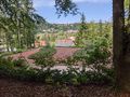
Weird tennis court golf course hybrid

Coordinates reached
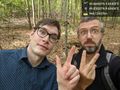
Hash number two (no offence to our fellow UK hashers) @49.8763,9.6061
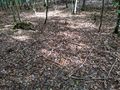
Xkcd marks the spot


Tracklog