Difference between revisions of "2020-10-31 47 7"
([live] Reached, waited 30 minutes, had a nice meeting with myself :-)) |
(→Expedition) |
||
| (7 intermediate revisions by 2 users not shown) | |||
| Line 1: | Line 1: | ||
| − | + | {{meetup graticule | |
| − | |||
| − | |||
| − | |||
| − | |||
| − | |||
| − | |||
| − | |||
| − | |||
| lat=47 | | lat=47 | ||
| lon=7 | | lon=7 | ||
| Line 14: | Line 6: | ||
__NOTOC__ | __NOTOC__ | ||
== Location == | == Location == | ||
| − | On the St. Peters island in the lake Biel. | + | On the St. Peters island in the lake of Biel. |
== Participants == | == Participants == | ||
| − | + | * [[User:Tungmar|Tungmar]] ([[User talk:Tungmar|talk]]) | |
| − | |||
== Plans == | == Plans == | ||
| Line 24: | Line 15: | ||
== Expedition == | == Expedition == | ||
| − | + | *Reached, waited 30 minutes, had a nice meeting with myself :-) -- [[User:Tungmar|Tungmar]] ([[User talk:Tungmar|talk]]) 16:24, 31 October 2020 (GMT+01:00) | |
| + | Yesterday evenig I saw that here is a possible hash in the area where I actually planed to go to yesterday (but see [[2020-10-30_46_7|2020-10-30 46 7]] for what happened instead). I had a long time to decide if I should stay in the hils or backtrack all the way to get the hash. Checking the weather forecast, it showed grey, cold and wet weather at the hash and warm sun where I was in the hill. No way I will go for the hash! | ||
| + | Today morning I checked the wather again. In the afternoon there should be sun! And my knees hurd and I didn't feel like hiking. That are all valid excuses to go for the hash, right? | ||
| + | I arrived at 15:00 with the bus in Erlach just 2 minutes later as planned. By now, there was no sign of sun. All just gray! The weather gurus tricked me! | ||
| + | Any way, there is no turning back and I started the over 4 km walk. I had to go fast to reach the hash at 16:00. It is a boring straight track flanked with high bushes and behind: Gray fog. At least the air was fresh and natural reservat was realaxing peaceful. Natural reservat? The hash is on the map a few meters of the track. And one should not leave the paths here. Maybe this will be a Mother Nature Reservats's Bitch Consolation Prize hash :-( | ||
| + | At 16:45 I passed a sign stating 15 minutes to the pier (which is a few meters further than the hash). Now I knew I could go easy and reach in time. But I keept the speed and 7 minutes later I arrived on the track in front of the hash. Now I had to first change the sweaty clothes to "fresh" ones. Then I realaxed and startet pinpointing the hash. After quite some time of jumping positions I middled the hash at a tree around 4m from the track. Unbelievable luckily there is some thing like a path passing close to the tree. It was easy to follow the path down, stick my one leg to the tree while keeping the other on the path and take a picture. I took more pictures standing on the track in order to not stamp to much on this barley visible path in the forest. | ||
| − | + | I waited with out hope for fellow hashers until 16:15 and starte packing. I had hope that there would be a ship to take me back, but the ship company stopped operations because of the pandemic. So I had to walk all the boring way back. But firs I went to the highest peak (474m above see (not lake)) and found a GeoCache on the way. | |
| − | |||
| − | |||
== Photos == | == Photos == | ||
| − | |||
| − | |||
| − | |||
<gallery perrow="5"> | <gallery perrow="5"> | ||
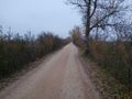
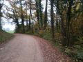
| + | Image:2020-10-31 47 7 Trak on the island.jpeg | Boring track on the island | ||
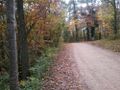
| + | Image:2020-10-31 47 7 View from the track.jpeg | View from the track next to the hash | ||
| + | Image:2020-10-31 47 7 Hashshot.jpeg | I actually stand on the track but hey, closest record ;-) | ||
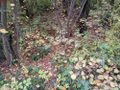
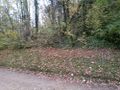
| + | Image:2020-10-31 47 7 Path to Hash.jpeg | Yes, this is a path! | ||
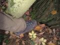
| + | Image:2020-10-31 47 7 Hashfoot.jpeg | Foot play with hash | ||
| + | Image:2020-10-31 47 7 View N.jpeg | View North | ||
| + | Image:2020-10-31 47 7 View E.jpeg | View East | ||
| + | Image:2020-10-31 47 7 View S.jpeg | View South | ||
| + | Image:2020-10-31 47 7 View W.jpeg | View West | ||
| + | Image:2020-10-31 47 7 Packing.jpeg | Repacking before leaving | ||
| + | Image:2020-10-31 47 7 Pier View Grey.jpeg | Sunny weather on the pier close to the hash | ||
| + | Image:2020-10-31 47 7 Pier View.jpeg | | ||
| + | Image:2020-10-31 47 7 Pier View Hash.jpeg | From pier towards the hash | ||
</gallery> | </gallery> | ||
== Achievements == | == Achievements == | ||
{{#vardefine:ribbonwidth|800px}} | {{#vardefine:ribbonwidth|800px}} | ||
| − | + | {{consecutive geohash | count=2 | latitude=46 | longitude=7 | date=2020-10-30 | name=[[User:Tungmar|Tungmar]]}} | |
| + | {{Minesweeper geohash | graticule = Zürich, Switzerland | ranknumber=2 | sw=true | w=true | name=[[User:Tungmar|Tungmar]]}} | ||
| + | {{Xkcd centurion|name=[[User:Tungmar|Tungmar]]|count=1}} | ||
| − | |||
| − | |||
| − | |||
| − | |||
| − | |||
| − | |||
| − | |||
| − | |||
| − | |||
| − | |||
| − | |||
| − | |||
| − | |||
| − | |||
[[Category:Expeditions]] | [[Category:Expeditions]] | ||
| − | + | [[Category:Expeditions with photos]] | |
| − | [[Category:Expeditions with photos]] | ||
| − | |||
| − | |||
| − | |||
| − | |||
| − | |||
[[Category:Coordinates reached]] | [[Category:Coordinates reached]] | ||
| − | + | {{location|CH|BE}} | |
| − | |||
| − | |||
| − | |||
| − | |||
| − | |||
| − | |||
| − | |||
| − | |||
| − | |||
| − | |||
| − | |||
| − | |||
| − | |||
| − | |||
| − | |||
| − | |||
| − | |||
Latest revision as of 16:55, 13 November 2020
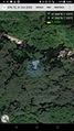
| Sat 31 Oct 2020 in 47,7: 47.0677525, 7.1385057 geohashing.info google osm bing/os kml crox |
Location
On the St. Peters island in the lake of Biel.
Participants
Plans
Expedition
- Reached, waited 30 minutes, had a nice meeting with myself :-) -- Tungmar (talk) 16:24, 31 October 2020 (GMT+01:00)
Yesterday evenig I saw that here is a possible hash in the area where I actually planed to go to yesterday (but see 2020-10-30 46 7 for what happened instead). I had a long time to decide if I should stay in the hils or backtrack all the way to get the hash. Checking the weather forecast, it showed grey, cold and wet weather at the hash and warm sun where I was in the hill. No way I will go for the hash! Today morning I checked the wather again. In the afternoon there should be sun! And my knees hurd and I didn't feel like hiking. That are all valid excuses to go for the hash, right?
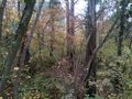
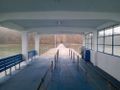
I arrived at 15:00 with the bus in Erlach just 2 minutes later as planned. By now, there was no sign of sun. All just gray! The weather gurus tricked me! Any way, there is no turning back and I started the over 4 km walk. I had to go fast to reach the hash at 16:00. It is a boring straight track flanked with high bushes and behind: Gray fog. At least the air was fresh and natural reservat was realaxing peaceful. Natural reservat? The hash is on the map a few meters of the track. And one should not leave the paths here. Maybe this will be a Mother Nature Reservats's Bitch Consolation Prize hash :-(
At 16:45 I passed a sign stating 15 minutes to the pier (which is a few meters further than the hash). Now I knew I could go easy and reach in time. But I keept the speed and 7 minutes later I arrived on the track in front of the hash. Now I had to first change the sweaty clothes to "fresh" ones. Then I realaxed and startet pinpointing the hash. After quite some time of jumping positions I middled the hash at a tree around 4m from the track. Unbelievable luckily there is some thing like a path passing close to the tree. It was easy to follow the path down, stick my one leg to the tree while keeping the other on the path and take a picture. I took more pictures standing on the track in order to not stamp to much on this barley visible path in the forest.
I waited with out hope for fellow hashers until 16:15 and starte packing. I had hope that there would be a ship to take me back, but the ship company stopped operations because of the pandemic. So I had to walk all the boring way back. But firs I went to the highest peak (474m above see (not lake)) and found a GeoCache on the way.
Photos
Boring track on the island

View from the track next to the hash
I actually stand on the track but hey, closest record ;-)
Yes, this is a path!
Foot play with hash
View North
View East
View South
View West
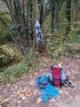
Repacking before leaving
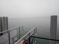
Sunny weather on the pier close to the hash
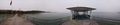
From pier towards the hash


Achievements
Tungmar earned the Consecutive geohash achievement
|
Tungmar achieved level 2 of the Minesweeper Geohash achievement
|
Tungmar earned the xkcd Nullaturion achievement
|