Difference between revisions of "2021-01-23 33 -111"
(Created page with "{{subst:Expedition |lat = 33 |lon = -111 |date = 2020-01-23 }}") |
m (Location) |
||
| (7 intermediate revisions by 2 users not shown) | |||
| Line 1: | Line 1: | ||
| − | + | {{meetup graticule | |
| − | |||
| − | |||
| − | |||
| − | |||
| − | |||
| − | |||
| − | |||
| − | |||
| lat=33 | | lat=33 | ||
| lon=-111 | | lon=-111 | ||
| − | | date= | + | | date=2021-01-23 |
}}<!-- edit as necessary --> | }}<!-- edit as necessary --> | ||
__NOTOC__ | __NOTOC__ | ||
== Location == | == Location == | ||
| − | + | In the Reach 11 Recreation Area, in Phoenix. | |
== Participants == | == Participants == | ||
| − | + | [[User:Lyricalcarpenter|Lyricalcarpenter]] ([[User talk:Lyricalcarpenter|talk]]) | |
| − | + | ||
| + | == Expedition == | ||
| + | This hash was located by one of the main aqueducts. There was a dike that cut off where I parked from the hashpoint. It was illegal to hike on the dike, so I quickly ran across and down the other side. From there, I walked some of the trails until I came to about 50 meters of the point. | ||
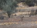
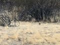
| − | + | By a stroke of luck, the point was in a grassy clearing, and not in the middle of the surrounding brush. I went north past the point, then doubled back into the clearing. On the way, I saw and photographed some quails. | |
| − | |||
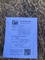
| − | + | I learned my lesson from [[2020-12-29 33 -112|last time,]] so I opted to take a picture of the Crox Poster laying on the point. To get the Music Achievement, I played the first few bars of "All was Well" by Wintergatan on the recorder. Apologies for poor audio quality. | |
| − | |||
| − | + | The quail pictures make me eligible for the Red Spider proposed achievement, but I couldn't get the ribbon to work in any meaningful way. | |
| − | |||
| − | == Photos == | + | == Photos == |
| − | |||
| − | |||
| − | |||
<gallery perrow="5"> | <gallery perrow="5"> | ||
| + | File:LC 2021-01-23 33 -111 Crox.jpg|thumb|Victory. | ||
| + | File:LC 2021-01-23 33-111 Quail1.jpg|thumb|Quail Group #1 | ||
| + | File:LC 2021-01-23 33 -111 Quail2.jpg|thumb|Quail Group #2 | ||
| + | File:LC 2021-01-23 33 -111 Overhead.jpg|thumb|View from atop the dike. | ||
| + | File:LC 2021-01-23 33-111 Music.MOV|thumb|Proof for the Music Achievement. | ||
</gallery> | </gallery> | ||
== Achievements == | == Achievements == | ||
{{#vardefine:ribbonwidth|800px}} | {{#vardefine:ribbonwidth|800px}} | ||
| − | + | {{musical achievement | |
| − | |||
| − | |||
| − | |||
| − | |||
| − | + | | latitude = 33 | |
| + | | longitude = -111 | ||
| + | | date = 2021-01-23 | ||
| + | | name = lyricalcarpenter | ||
| + | | count = 1 | ||
| + | | instrument = the recorder | ||
| + | }} | ||
| + | {{Two to the N achievement | ||
| − | + | | count = 1 | |
| − | + | | date = 2021-01-23 | |
| − | + | | latitude = 33 | |
| − | + | | longitude = -111 | |
| + | | name = lyricalcarpenter | ||
| + | | reached = true | ||
| + | }} | ||
| − | |||
| − | |||
| − | |||
[[Category:Expeditions]] | [[Category:Expeditions]] | ||
| − | |||
[[Category:Expeditions with photos]] | [[Category:Expeditions with photos]] | ||
| − | [[Category:Expeditions with | + | [[Category:Expeditions with audio]] |
| − | |||
| − | |||
| − | |||
| − | |||
[[Category:Coordinates reached]] | [[Category:Coordinates reached]] | ||
| − | + | {{location|US|AZ|MA}} | |
| − | |||
| − | |||
| − | |||
| − | |||
| − | |||
| − | |||
| − | |||
| − | |||
| − | |||
| − | |||
| − | |||
| − | |||
| − | |||
| − | |||
| − | |||
| − | |||
| − | |||
Latest revision as of 13:42, 24 January 2021
| Sat 23 Jan 2021 in 33,-111: 33.6565403, -111.9717943 geohashing.info google osm bing/os kml crox |
Location
In the Reach 11 Recreation Area, in Phoenix.
Participants
Expedition
This hash was located by one of the main aqueducts. There was a dike that cut off where I parked from the hashpoint. It was illegal to hike on the dike, so I quickly ran across and down the other side. From there, I walked some of the trails until I came to about 50 meters of the point.
By a stroke of luck, the point was in a grassy clearing, and not in the middle of the surrounding brush. I went north past the point, then doubled back into the clearing. On the way, I saw and photographed some quails.
I learned my lesson from last time, so I opted to take a picture of the Crox Poster laying on the point. To get the Music Achievement, I played the first few bars of "All was Well" by Wintergatan on the recorder. Apologies for poor audio quality.
The quail pictures make me eligible for the Red Spider proposed achievement, but I couldn't get the ribbon to work in any meaningful way.
Photos
Victory.
Quail Group #1
Quail Group #2
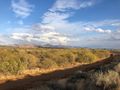
View from atop the dike.
Proof for the Music Achievement.


Achievements
lyricalcarpenter earned the Musical achievement
|
