Difference between revisions of "2021-02-03 52 10"
From Geohashing
(last man standing) |
m (Adding hours) |
||
| (One intermediate revision by the same user not shown) | |||
| Line 54: | Line 54: | ||
[[Category:Expeditions with photos]] | [[Category:Expeditions with photos]] | ||
{{location|DE|NI|PE}} | {{location|DE|NI|PE}} | ||
| − | + | {{user categories|user=Fippe|bike=45|hours=11}} | |
Latest revision as of 19:33, 11 December 2022
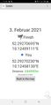
| Wed 3 Feb 2021 in Braunschweig: 52.2927070, 10.1245911 geohashing.info google osm bing/os kml crox |
Location
This Geohash is located on a field in Equord.
Participants
Expedition
I took the bicycle to Equord. The final path leading me to the field containing the Geohash wasn't mapped on OSM. It had been raining, so the field was quite muddy. I located the coordinates and recorded proof.
Afterwards, I rode the bicycle back home.
Photos
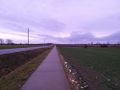
On the way to the Geohash
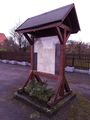
In Equord
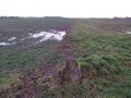
The site of the Geohash
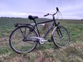
My bicycle near the coordinates
Proof
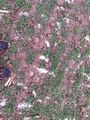
The Geohash
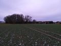
Surroundings
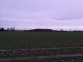
Surroundings
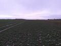
Surroundings
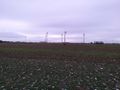
Surroundings


Distance as the crow flies: 20 km
My path: 22.5 km
Maximum deviation on the way there: 1.14 km - too much
Maximum deviation on the way back: 0.98 km - just enough
Tracklog
Achievements
Fippe earned the Land geohash achievement
|
Fippe earned the Bicycle geohash achievement
|
Fippe earned the OpenStreetMap achievement
|
Fippe earned the Juggernaut achievement
|
Fippe earned the Last man standing achievement
|
Categories:
- Meetup on 2021-02-03
- Meetup in 52 10
- Expeditions with tracklogs
- Land geohash achievement
- Bicycle geohash achievement
- OpenStreetMap achievement
- Juggernaut achievement
- Last man standing achievement
- Expeditions
- Coordinates reached
- Expeditions with photos
- Meetup in Landkreis Peine
- Expeditions by Fippe
- Fippe's expeditions by bike