Difference between revisions of "2021-02-06 32 -96"
From Geohashing
(page created) |
m (Location) |
||
| (5 intermediate revisions by one other user not shown) | |||
| Line 15: | Line 15: | ||
== Location == | == Location == | ||
<!-- where you've surveyed the hash to be --> | <!-- where you've surveyed the hash to be --> | ||
| + | In a vacant lot next to an intersection, across from a gas station, and next to a small creek. | ||
| + | |||
| + | what3words: [https://w3w.co/star.pumps.crowds ///star.pumps.crowds] ([https://what3words.com/about-us/ what is this?]) | ||
== Participants == | == Participants == | ||
<!-- who attended: If you link to your wiki user name in this section, your expedition will be picked up by the various statistics generated for geohashing. You may use three tildes ~ as a shortcut to automatically insert the user signature of the account you are editing with. | <!-- who attended: If you link to your wiki user name in this section, your expedition will be picked up by the various statistics generated for geohashing. You may use three tildes ~ as a shortcut to automatically insert the user signature of the account you are editing with. | ||
--> | --> | ||
| + | * [[User:Luke|Luke]] - a human | ||
| + | * Emily - a dog | ||
== Plans == | == Plans == | ||
<!-- what were the original plans --> | <!-- what were the original plans --> | ||
| + | This was Luke's first planned geohash. He planned to park at the gas station and cross the street. | ||
== Expedition == | == Expedition == | ||
<!-- how it all turned out. your narrative goes here. --> | <!-- how it all turned out. your narrative goes here. --> | ||
| − | + | Luke took his dog Emily in the car down to the Trinity River trails for a jog. After that, they picked up beer from Pegasus City Brewing. From there, they swung over to the gas station across the street from the hashpoint and crossed the street. They explored the lot and creek nearby, before finding the exact point for a picture just after 4pm. | |
| − | |||
| − | |||
== Photos == | == Photos == | ||
| Line 34: | Line 38: | ||
--> | --> | ||
<gallery perrow="5"> | <gallery perrow="5"> | ||
| + | Image:2021-02-06 32 -96 01.jpg | The participants | ||
| + | Image:2021-02-06 32 -96 02.jpg | Proof | ||
| + | Image:2021-02-06 32 -96 03.jpg | At the hashpoint | ||
| + | Image:2021-02-06 32 -96 04.jpg | View of intersection | ||
| + | Image:2021-02-06 32 -96 05.jpg | View of creek | ||
</gallery> | </gallery> | ||
| Line 39: | Line 48: | ||
{{#vardefine:ribbonwidth|800px}} | {{#vardefine:ribbonwidth|800px}} | ||
<!-- Add any achievement ribbons you earned below, or remove this section --> | <!-- Add any achievement ribbons you earned below, or remove this section --> | ||
| + | {{land geohash | ||
| + | | latitude = 32 | ||
| + | | longitude = -96 | ||
| + | | date = 2021-02-06 | ||
| + | | name = [[User:Luke|Luke]] | ||
| + | }} | ||
<!-- =============== USEFUL CATEGORIES FOLLOW ================ | <!-- =============== USEFUL CATEGORIES FOLLOW ================ | ||
Delete the next line ONLY if you have chosen the appropriate categories below. If you are unsure, don't worry. People will read your report and help you with the classification. --> | Delete the next line ONLY if you have chosen the appropriate categories below. If you are unsure, don't worry. People will read your report and help you with the classification. --> | ||
| − | |||
<!-- ==REQUEST FOR TWITTER BOT== Please leave either the New report or the Expedition planning category in as long as you work on it. This helps the twitter bot a lot with announcing the right outcome at the right moment. --> | <!-- ==REQUEST FOR TWITTER BOT== Please leave either the New report or the Expedition planning category in as long as you work on it. This helps the twitter bot a lot with announcing the right outcome at the right moment. --> | ||
| Line 53: | Line 67: | ||
<!-- If all those plans are never acted upon, change [[Category:Expedition planning]] to [[Category:Not reached - Did not attempt]]. --> | <!-- If all those plans are never acted upon, change [[Category:Expedition planning]] to [[Category:Not reached - Did not attempt]]. --> | ||
| − | + | ||
[[Category:Expeditions]] | [[Category:Expeditions]] | ||
| − | + | ||
[[Category:Expeditions with photos]] | [[Category:Expeditions with photos]] | ||
| − | + | ||
| − | |||
| − | |||
| − | |||
| − | |||
[[Category:Coordinates reached]] | [[Category:Coordinates reached]] | ||
| − | + | <!-- or if you failed :( | |
[[Category:Coordinates not reached]] | [[Category:Coordinates not reached]] | ||
-- and a reason -- | -- and a reason -- | ||
| Line 81: | Line 91: | ||
(Don't forget to delete this final close comment marker) --> | (Don't forget to delete this final close comment marker) --> | ||
| + | {{location|US|TX|DS}} | ||
Latest revision as of 05:42, 12 February 2021
| Sat 6 Feb 2021 in 32,-96: 32.7667093, -96.8028228 geohashing.info google osm bing/os kml crox |
Location
In a vacant lot next to an intersection, across from a gas station, and next to a small creek.
what3words: ///star.pumps.crowds (what is this?)
Participants
- Luke - a human
- Emily - a dog
Plans
This was Luke's first planned geohash. He planned to park at the gas station and cross the street.
Expedition
Luke took his dog Emily in the car down to the Trinity River trails for a jog. After that, they picked up beer from Pegasus City Brewing. From there, they swung over to the gas station across the street from the hashpoint and crossed the street. They explored the lot and creek nearby, before finding the exact point for a picture just after 4pm.
Photos
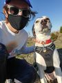
The participants
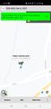
Proof
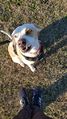
At the hashpoint
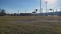
View of intersection
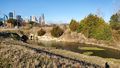
View of creek


Achievements
Luke earned the Land geohash achievement
|