Difference between revisions of "2021-03-29 50 7"
Gefrierbrand (talk | contribs) (Created page with "{{subst:Expedition |lat = 50 |lon = 7 |date = 2021-03-29 }}") |
Gefrierbrand (talk | contribs) |
||
| (12 intermediate revisions by 2 users not shown) | |||
| Line 1: | Line 1: | ||
| − | + | {{meetup graticule | |
| − | |||
| − | |||
| − | |||
| − | |||
| − | |||
| − | |||
| − | |||
| − | |||
| lat=50 | | lat=50 | ||
| lon=7 | | lon=7 | ||
| date=2021-03-29 | | date=2021-03-29 | ||
| − | }} | + | }} |
__NOTOC__ | __NOTOC__ | ||
== Location == | == Location == | ||
| − | + | In a field near Saffig | |
== Participants == | == Participants == | ||
| − | + | *[[User:Santu|Santu]] | |
| − | + | *[[User:Gefrierbrand|Gefrierbrand]] | |
| + | *Pedro the Dog | ||
== Plans == | == Plans == | ||
| − | + | feast, walk there barefoot, take pictures, look around. | |
== Expedition == | == Expedition == | ||
| − | + | We wanted to make use of the beautiful weather and the fact that the hashlocation was relatively near to Gefierbrands home so we drove to Saffig, made sure the remaining distance was at least 1km and walked from there. Since we had intended to do the Hobbit achievement, we also had feasted several times along the day and during the expedition and forged a special ring for Pedro. Santu and Gefierbrand also carried rings, because why should there be only one, or even the one ring? | |
| + | |||
| + | Walking barefoot was surprisingly funny for the first few meters and then unsurprisingly painful, except for Pedro who did not understand what all the fuss was about and why we were walking much slower and less straight than usual. | ||
| + | |||
| + | We were passed by a few pedestrians and joggers who gave us confused looks. | ||
| + | |||
| + | The Hashpoint was located in a field about 20 meters of the path. The ground was softer and a little more comfortable to walk on, but the already growing plants made it hard to see what we were stepping on. Luckyly there were no hidden sharp stones or something like that. | ||
| + | |||
| + | Of course, we feasted again and then continued towards a nearby location which was marked simply as "good view" on google maps. | ||
| + | It was indeed a nice view from there as the attached panorama shows. | ||
| − | + | On our way back we also experimented in walking blindly and concluded that Pedro would be an awful guide-dog, but he did manage to spot a deer from an impressive distance. | |
| − | |||
== Photos == | == Photos == | ||
| − | |||
| − | |||
| − | |||
<gallery perrow="5"> | <gallery perrow="5"> | ||
| + | Image:2021-03-29_50_7_Gefrierbrand_1617094794432.jpg|Stupid grin<sup>TM</sup> along the way | ||
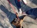
| + | Image:2021-03-29_50_7_Gefrierbrand_1617094754236.jpg|Bare Feet at the Haspoint | ||
| + | Image:2021-03-29_50_7_Gefrierbrand_1617094805747.jpg|proof | ||
| + | Image:2021-03-29_50_7_Gefrierbrand_1617094836969.jpg|many rings | ||
| + | Image:2021-03-29_50_7_Gefrierbrand_1617094916781.jpg|confused dog | ||
| + | Image:2021-03-29 50 7 niceview.jpg|Panorama from "nice view" location | ||
</gallery> | </gallery> | ||
== Achievements == | == Achievements == | ||
{{#vardefine:ribbonwidth|800px}} | {{#vardefine:ribbonwidth|800px}} | ||
| − | + | {{land geohash | |
| + | | latitude = 50 | ||
| + | | longitude = 7 | ||
| + | | date = 2021-03-29 | ||
| + | | name = Gefrierbrand & Santu | ||
| + | }} | ||
| + | {{Hobbit achievement | ||
| + | | latitude = 50 | ||
| + | | longitude = 7 | ||
| + | | date = 2021-03-29 | ||
| + | | pronoun = their | ||
| + | | name = Gefrierbrand & Santu | ||
| + | }} | ||
| + | {{Two to the N achievement | ||
| + | | count = 4 | ||
| + | | date = 2021-03-29 | ||
| + | | latitude = 50 | ||
| + | | longitude = 7 | ||
| + | | name = Gefrierbrand | ||
| + | | reached = true | ||
| + | }} | ||
| − | |||
| − | |||
| − | |||
| − | |||
| − | |||
| − | |||
| − | |||
| − | |||
| − | |||
| − | |||
| − | |||
| − | |||
| − | |||
| − | |||
[[Category:Expeditions]] | [[Category:Expeditions]] | ||
| − | |||
[[Category:Expeditions with photos]] | [[Category:Expeditions with photos]] | ||
| − | |||
| − | |||
| − | |||
| − | |||
| − | |||
[[Category:Coordinates reached]] | [[Category:Coordinates reached]] | ||
| − | + | [[Category:Expeditions with dogs]] | |
| − | + | {{location|DE|RP|MYK}} | |
| − | |||
| − | |||
| − | |||
| − | |||
| − | |||
| − | |||
| − | |||
| − | |||
| − | |||
| − | |||
| − | [[Category: | ||
| − | |||
| − | |||
| − | |||
| − | |||
| − | |||
Latest revision as of 07:54, 18 October 2022
| Mon 29 Mar 2021 in 50,7: 50.3910060, 7.4310398 geohashing.info google osm bing/os kml crox |
Location
In a field near Saffig
Participants
- Santu
- Gefrierbrand
- Pedro the Dog
Plans
feast, walk there barefoot, take pictures, look around.
Expedition
We wanted to make use of the beautiful weather and the fact that the hashlocation was relatively near to Gefierbrands home so we drove to Saffig, made sure the remaining distance was at least 1km and walked from there. Since we had intended to do the Hobbit achievement, we also had feasted several times along the day and during the expedition and forged a special ring for Pedro. Santu and Gefierbrand also carried rings, because why should there be only one, or even the one ring?
Walking barefoot was surprisingly funny for the first few meters and then unsurprisingly painful, except for Pedro who did not understand what all the fuss was about and why we were walking much slower and less straight than usual.
We were passed by a few pedestrians and joggers who gave us confused looks.
The Hashpoint was located in a field about 20 meters of the path. The ground was softer and a little more comfortable to walk on, but the already growing plants made it hard to see what we were stepping on. Luckyly there were no hidden sharp stones or something like that.
Of course, we feasted again and then continued towards a nearby location which was marked simply as "good view" on google maps. It was indeed a nice view from there as the attached panorama shows.
On our way back we also experimented in walking blindly and concluded that Pedro would be an awful guide-dog, but he did manage to spot a deer from an impressive distance.
Photos
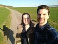
Stupid grinTM along the way
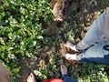
Bare Feet at the Haspoint
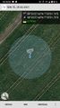
proof
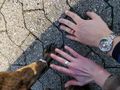
many rings
confused dog

Panorama from "nice view" location


Achievements
Gefrierbrand & Santu earned the Land geohash achievement
|
Gefrierbrand & Santu earned the Hobbit Achievement
|
