Difference between revisions of "2021-05-18 62 29"
| (4 intermediate revisions by 2 users not shown) | |||
| Line 14: | Line 14: | ||
Seems like an [[Easy Geohash]] opportunity. I could route my way to work so that visiting this hashpoint would only be a 30-metre detour, and the route would not even be significantly longer than my usual route through the grid plan of the centrum. This is if I actually go to my workplace – we have remote working recommendation in place, but I can go there if I want to. In any case, I will go and visit the hashpoint. | Seems like an [[Easy Geohash]] opportunity. I could route my way to work so that visiting this hashpoint would only be a 30-metre detour, and the route would not even be significantly longer than my usual route through the grid plan of the centrum. This is if I actually go to my workplace – we have remote working recommendation in place, but I can go there if I want to. In any case, I will go and visit the hashpoint. | ||
| − | It would have been even more awesome if the point had been 300 metres to the north-northeast. In that case, it would have lied on Rauhankatu (Peace Street), which would have allowed me to complete the [[A Tale of Two Hashes achievement|Tale of Two Hashes]] of [[2012-02-17 49 9]]. This street is Kirkkokatu (Church Street) which would also be a worthy location for the challenge. | + | It would have been even more awesome if the point had been 300 metres to the north-northeast. In that case, it would have lied on Rauhankatu (Peace Street), which would have allowed me to complete the [[A Tale of Two Hashes achievement|Tale of Two Hashes]] of [[2012-02-17 49 9]]. This street is Kirkkokatu (Church Street) which would also be a worthy location for the challenge. |
| − | Also, there is a [[Holy_hash_achievement|church]] and another church building just across the streets, but the hashpoint is unfortunately on the yard of a residential building. It is not on private property ( | + | Also, there is a [[Holy_hash_achievement|church]] and another church building just across the streets, but the hashpoint is unfortunately on the yard of a residential building. It is not on private property (the property itself is owned by the housing cooperative), so it should be legal to enter. |
== Expedition == | == Expedition == | ||
| − | + | I ended up not going to the workplace, so I just visited the hashpoint from my home by bicycle. The location was easy enough that I decided to reach it [[No Batteries Geohash|without electronic navigation aids]]: I drew a rough map using the topographic map and the aerial image of the National Land Survey of Finland. I wrote down the distances from the footpath and from the line extending from a nearby wall of the building, which would be enough for getting to the correct spot. | |
| − | + | I also realised that there is a bar down the street, and it would open at 14:00. The distance to the hashpoint was about 350 metres or two blocks. I did not know in advance whether there would be a line of sight between them – otherwise there would definitely be, but there are many trees growing by the street potentially blocking the view. | |
| − | + | ||
| + | As expected, I had no trouble reaching the hashpoint. I took a few quick pictures of the hashpoint and also the church, the other church building (administrative building) and the street sign at the intersection. Then I tried to see the front of the bar from the vicinity of the hashpoint. I was unsuccessful, for I could see stuff between the tree trunks but not much detail that far away, so I went to the bar and looked back to the hashpoint. Standing in front of the bar, I could see the geohash site, so there was definitely a clear line of sight. It is admittedly in a grey area, but I guess that in a graticule with about 40 pubs, half of which are in the tiny centrum of Joensuu, it is close enough. I went to the bar and had a glass of rosé. | ||
| + | |||
| + | I will also throw in [[A Tale of Two Hashes achievement|A Tale of Two Hashes challenge]]: reach a geohash in a place named Kirkkokatu or the equivalent in another language (Church Street, Kirchenstraße, Rue de l'Église, etc.). I will happily accept any synonym of "street" too. | ||
== Photos == | == Photos == | ||
| − | < | + | <gallery perrow="4"> |
| − | Image: | + | Image:2021-05-18_62_29_01-map.jpg | The map that I drew of the hashpoint area. Not to scale, but the distances (in metres) are correct. |
| − | -- | + | Image:2021-05-18_62_29_02-hashpoint1.jpg | The surroundings of the hashpoint. The point itself is approximately at the manhole cover in the middle. |
| − | + | Image:2021-05-18_62_29_03-hashpoint2.jpg | Standing at the hashpoint. No visual proof of date, but the EXIF timestamp is correct. | |
| + | Image:2021-05-18_62_29_04-street.jpg | Photo of the intersection showing the street name and the geohash site in the background. | ||
| + | Image:2021-05-18_62_29_05-church.jpg | The orthodox church of Joensuu. | ||
| + | Image:2021-05-18_62_29_06-building.jpg | An administrative building of the church. | ||
| + | Image:2021-05-18_62_29_07-bar.jpg | Sointula bar down the street. | ||
| + | Image:2021-05-18_62_29_08-beverage.jpg | Having a glass of rosé at the bar. | ||
</gallery> | </gallery> | ||
== Achievements == | == Achievements == | ||
{{#vardefine:ribbonwidth|800px}} | {{#vardefine:ribbonwidth|800px}} | ||
| − | + | {{land geohash | latitude = 62 | longitude = 29 | date = 2021-05-18 | user = Kripakko}} | |
| − | + | {{bicycle geohash | latitude = 62 | longitude = 29 | date = 2021-05-18 | user = Kripakko | distance = 7.5 km | bothways = true}} | |
| − | + | {{No_batteries_geohash | latitude = 62 | longitude = 29 | date = 2021-05-18 | user = Kripakko}} | |
| − | + | {{pub geohash | latitude = 62 | longitude = 29 | date = 2021-05-18 | user = Kripakko}} | |
| − | + | {{A Tale of Two Hashes challenge | latitude = 62 | longitude = 29 | date = 2021-05-18 | name = Kripakko | place = Kirkkokatu (Church Street) | image = 2021-05-18_62_29_04-street.jpg}} | |
| − | |||
| − | |||
| − | |||
| − | |||
| − | |||
| − | |||
| − | |||
| − | |||
| − | |||
| − | |||
[[Category:Expeditions]] | [[Category:Expeditions]] | ||
| − | |||
[[Category:Expeditions with photos]] | [[Category:Expeditions with photos]] | ||
| − | |||
[[Category:Expedition without GPS]] | [[Category:Expedition without GPS]] | ||
| − | |||
| − | |||
| − | |||
[[Category:Coordinates reached]] | [[Category:Coordinates reached]] | ||
| − | + | {{location|FI|13}} | |
| − | |||
| − | |||
| − | |||
| − | |||
| − | |||
| − | |||
| − | |||
| − | |||
| − | |||
| − | |||
| − | |||
| − | |||
| − | |||
| − | |||
| − | |||
| − | |||
| − | |||
Revision as of 16:52, 18 May 2021
| Tue 18 May 2021 in 62,29: 62.6055534, 29.7625573 geohashing.info google osm bing/os kml crox |
Location
Kirkkokatu 37 in the centrum of Joensuu.
Participants
Plans
Seems like an Easy Geohash opportunity. I could route my way to work so that visiting this hashpoint would only be a 30-metre detour, and the route would not even be significantly longer than my usual route through the grid plan of the centrum. This is if I actually go to my workplace – we have remote working recommendation in place, but I can go there if I want to. In any case, I will go and visit the hashpoint.
It would have been even more awesome if the point had been 300 metres to the north-northeast. In that case, it would have lied on Rauhankatu (Peace Street), which would have allowed me to complete the Tale of Two Hashes of 2012-02-17 49 9. This street is Kirkkokatu (Church Street) which would also be a worthy location for the challenge.
Also, there is a church and another church building just across the streets, but the hashpoint is unfortunately on the yard of a residential building. It is not on private property (the property itself is owned by the housing cooperative), so it should be legal to enter.
Expedition
I ended up not going to the workplace, so I just visited the hashpoint from my home by bicycle. The location was easy enough that I decided to reach it without electronic navigation aids: I drew a rough map using the topographic map and the aerial image of the National Land Survey of Finland. I wrote down the distances from the footpath and from the line extending from a nearby wall of the building, which would be enough for getting to the correct spot.
I also realised that there is a bar down the street, and it would open at 14:00. The distance to the hashpoint was about 350 metres or two blocks. I did not know in advance whether there would be a line of sight between them – otherwise there would definitely be, but there are many trees growing by the street potentially blocking the view.
As expected, I had no trouble reaching the hashpoint. I took a few quick pictures of the hashpoint and also the church, the other church building (administrative building) and the street sign at the intersection. Then I tried to see the front of the bar from the vicinity of the hashpoint. I was unsuccessful, for I could see stuff between the tree trunks but not much detail that far away, so I went to the bar and looked back to the hashpoint. Standing in front of the bar, I could see the geohash site, so there was definitely a clear line of sight. It is admittedly in a grey area, but I guess that in a graticule with about 40 pubs, half of which are in the tiny centrum of Joensuu, it is close enough. I went to the bar and had a glass of rosé.
I will also throw in A Tale of Two Hashes challenge: reach a geohash in a place named Kirkkokatu or the equivalent in another language (Church Street, Kirchenstraße, Rue de l'Église, etc.). I will happily accept any synonym of "street" too.
Photos
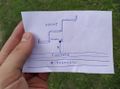
The map that I drew of the hashpoint area. Not to scale, but the distances (in metres) are correct.
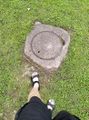
The surroundings of the hashpoint. The point itself is approximately at the manhole cover in the middle.
Standing at the hashpoint. No visual proof of date, but the EXIF timestamp is correct.
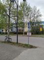
Photo of the intersection showing the street name and the geohash site in the background.
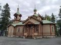
The orthodox church of Joensuu.
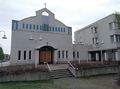
An administrative building of the church.
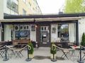
Sointula bar down the street.

Having a glass of rosé at the bar.


Achievements
This user earned the Land geohash achievement
|
This user earned the Bicycle geohash achievement
|
This user earned the No Batteries Geohash Achievement
|
This user earned the Pub Geohash Achievement
|

