Difference between revisions of "2021-05-24 52 9"
(→Plans) |
m (Adding hours) |
||
| (8 intermediate revisions by 4 users not shown) | |||
| Line 1: | Line 1: | ||
| − | + | {{meetup graticule | |
| + | |date = 2021-05-24 | ||
| + | |lat = 52 | ||
| + | |lon = 9 | ||
| + | |graticule_name = Hannover | ||
| + | |graticule_link = 52,9 | ||
| + | }} | ||
| − | [[ | + | ==Location== |
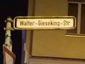
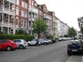
| + | This Geohash is located on ''Walter-Gieseking-Straße'' in [[wikipedia:Hannover|Hannover]]. | ||
| − | + | ==Participants== | |
| − | + | *[[User:DLichti|DLichti]] ([[User talk:DLichti|talk]]) | |
| + | *[[User:Fippe|Fippe]] | ||
| + | *[[User:GeorgDerReisende|GeorgDerReisende]] | ||
| − | + | ==Plans== | |
| − | + | Take the subway to Marienstraße, look around, do some OSM mapping... --[[User:DLichti|DLichti]] | |
| − | |||
| − | |||
| − | |||
| − | |||
| − | |||
| − | |||
| − | |||
| − | |||
| − | |||
| − | |||
| − | |||
| − | |||
| − | |||
| − | == Plans == | ||
| − | |||
| − | Take the subway to | ||
* But when? --[[User:GeorgDerReisende|GeorgDerReisende]] | * But when? --[[User:GeorgDerReisende|GeorgDerReisende]] | ||
| + | ** 12:00 is fine, will be there. [[User:DLichti|DLichti]] ([[User talk:DLichti|talk]]) | ||
| − | + | I'm open to visit the hash again if you tell me when you are going. --[[User:Fippe|Fippe]] | |
| − | + | * I am leaving my castle at 8 o'clock and will arrive at the hash around 12 o'clock. --[[User:GeorgDerReisende|GeorgDerReisende]] | |
| − | == | + | ==Expedition== |
| − | < | + | ===Fippe=== |
| − | + | I cycled to to the coordinates arriving a few minutes before midnight. The way was almost a perfectly straight line, but I won't bother calculating the exact deviation because the largest deviation was at my home, putting it at a classical 1:20. At midnight I recorded proof and cycled back home. Twelve hours later I repeated the journey, DLichti and GeorgDerReisende arrived around 12:00. | |
| − | == | + | ===GeorgDerReisende=== |
| − | < | + | I left my castle at 8 o'clock and traveled by bus and two trains to Hannover, then I walked to the hash. There I met Fippe and Dlichti. I looked for the coordinates on my own, but after several tries I got the best result with a two meter reading. We talked a bit and then we left in our each directions. |
| − | + | ==Photos== | |
| − | -- | + | ===Fippe=== |
| − | + | [[File:2021-05-24 52 9 05 Surroundings.jpg|1000px|Surroundings]] | |
| + | <gallery> | ||
| + | 2021-05-24 52 9 01 Walter-Gieseking-Str.jpg | In the destination street | ||
| + | 2021-05-24 52 9 02 Proof.jpg | Proof | ||
| + | 2021-05-24 52 9 03 Geohash.jpg | The Geohash | ||
| + | 2021-05-24 52 9 04 Site.jpg | The site of the Geohash | ||
| + | </gallery> | ||
| + | [[File:2021-05-24 52 9 07 Surroundings.jpg|1000px|Surroundings]] | ||
| + | ===GeorgDerReisende=== | ||
| + | <gallery> | ||
| + | File:2021-05-24 52 9 GeorgDerReisende 7145.jpg | proof | ||
| + | File:2021-05-24 52 9 GeorgDerReisende 7147.jpg | proof 2 | ||
| + | File:2021-05-24 52 9 GeorgDerReisende 7148.jpg | the geohash | ||
| + | File:2021-05-24 52 9 GeorgDerReisende 7151.jpg | looking north | ||
| + | File:2021-05-24 52 9 GeorgDerReisende 7152.jpg | east | ||
| + | File:2021-05-24 52 9 GeorgDerReisende 7153.jpg | south | ||
| + | File:2021-05-24 52 9 GeorgDerReisende 7154.jpg | west | ||
| + | File:2021-05-24 52 9 GeorgDerReisende 7156.jpg | the whole site | ||
</gallery> | </gallery> | ||
| − | == | + | ==Tracklog== |
| − | {{ | + | ===Fippe=== |
| − | + | {{tracklog|2021-05-24 52 9 06 Tracklog.gpx}} | |
| − | + | ==Achievements== | |
| − | + | {{#vardefine:ribbonwidth|100%}} | |
| + | {{land geohash|date=2021-05-24|latitude=52|longitude=9|name=[[User:Fippe|Fippe]]|image=2021-05-24 52 9 03 Geohash.jpg}} | ||
| + | {{bicycle geohash|date=2021-05-24|latitude=52|longitude=9|name=[[User:Fippe|Fippe]]|distance=15 km|bothways=true|image=2021-05-24 52 9 04 Site.jpg}} | ||
| + | {{midnight geohash|date=2021-05-24|latitude=52|longitude=9|name=[[User:Fippe|Fippe]]|image=2021-05-24 52 9 02 Proof.jpg}} | ||
| + | {{juggernaut achievement|date=2021-05-24|latitude=52|longitude=9|deviation=20|name=[[User:Fippe|Fippe]]}} | ||
| + | {{meetup|latitude=52|longitude=9|date=2021-05-24|name=[[User:GeorgDerReisende|GeorgDerReisende]] and [[User:DLichti|DLichti]]|other=each other}} | ||
| − | + | __NOTOC__ | |
| − | |||
| − | |||
| − | |||
| − | |||
| − | |||
| − | |||
| − | |||
[[Category:Expeditions]] | [[Category:Expeditions]] | ||
| − | + | [[Category:Coordinates reached]] | |
[[Category:Expeditions with photos]] | [[Category:Expeditions with photos]] | ||
| − | + | {{location|DE|NI|H}} | |
| − | + | {{user categories|user=Fippe|bike=30|hours=00 11 12}} | |
| − | |||
| − | |||
| − | |||
| − | |||
| − | |||
| − | |||
| − | |||
| − | |||
| − | |||
| − | |||
| − | |||
| − | |||
| − | |||
| − | |||
| − | |||
| − | |||
| − | |||
| − | |||
| − | |||
| − | |||
| − | |||
| − | |||
Latest revision as of 19:40, 11 December 2022
| Mon 24 May 2021 in Hannover: 52.3713875, 9.7534261 geohashing.info google osm bing/os kml crox |
Location
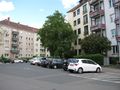
This Geohash is located on Walter-Gieseking-Straße in Hannover.
Participants
Plans
Take the subway to Marienstraße, look around, do some OSM mapping... --DLichti
- But when? --GeorgDerReisende
I'm open to visit the hash again if you tell me when you are going. --Fippe
- I am leaving my castle at 8 o'clock and will arrive at the hash around 12 o'clock. --GeorgDerReisende
Expedition
Fippe
I cycled to to the coordinates arriving a few minutes before midnight. The way was almost a perfectly straight line, but I won't bother calculating the exact deviation because the largest deviation was at my home, putting it at a classical 1:20. At midnight I recorded proof and cycled back home. Twelve hours later I repeated the journey, DLichti and GeorgDerReisende arrived around 12:00.
GeorgDerReisende
I left my castle at 8 o'clock and traveled by bus and two trains to Hannover, then I walked to the hash. There I met Fippe and Dlichti. I looked for the coordinates on my own, but after several tries I got the best result with a two meter reading. We talked a bit and then we left in our each directions.
Photos
Fippe

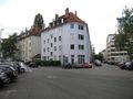
In the destination street
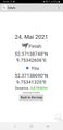
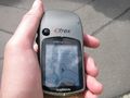
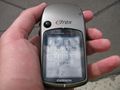
Proof
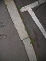
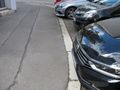
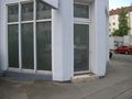
The Geohash
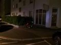
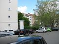
The site of the Geohash


GeorgDerReisende
proof
proof 2
the geohash
looking north
east
south
west
the whole site


Tracklog
Fippe
Achievements
Fippe earned the Land geohash achievement
|
Fippe earned the Bicycle geohash achievement
|
Fippe earned the Midnight Geohash achievement
|
Fippe earned the Juggernaut achievement
|
GeorgDerReisende and DLichti earned the Meet-up achievement
|
- Meetup on 2021-05-24
- Meetup in 52 9
- Expeditions with tracklogs
- Land geohash achievement
- Bicycle geohash achievement
- Midnight geohash achievement
- Juggernaut achievement
- Meet-up achievement
- Expeditions
- Coordinates reached
- Expeditions with photos
- Meetup in Region Hannover
- Expeditions by Fippe
- Fippe's expeditions by bike