Difference between revisions of "2021-06-13 40 -4"
m (Location) |
m (→Expedition) |
||
| Line 32: | Line 32: | ||
<!-- how it all turned out. your narrative goes here. --> | <!-- how it all turned out. your narrative goes here. --> | ||
The route to the geohash passed by | The route to the geohash passed by | ||
| − | the one I reached on 2021-06- | + | the one I reached on expedition [[2021-06-06_40_-4]] and |
was just a little further, so there were not many new | was just a little further, so there were not many new | ||
roads to discover. | roads to discover. | ||
| Line 40: | Line 40: | ||
photo of a funny artificial hill which I had already | photo of a funny artificial hill which I had already | ||
noticed on the first ride. | noticed on the first ride. | ||
| + | Later, on expedition [[2022-01-02_40_-4]], I reached a geohash close by. | ||
The geohash was very close to the road and in principle | The geohash was very close to the road and in principle | ||
Latest revision as of 07:56, 5 January 2022
| Sun 13 Jun 2021 in 40,-4: 40.0629895, -4.1767073 geohashing.info google osm bing/os kml crox |
Location
In a grain field by the side of the road near Fuensalida.
Participants
Plans
Expedition
The route to the geohash passed by the one I reached on expedition 2021-06-06_40_-4 and was just a little further, so there were not many new roads to discover. Usually, I don't stop on the cruise to a geohash to take photos. I feel it spoils the riding experience. However, this time, riding the same road a second time, I took a photo of a funny artificial hill which I had already noticed on the first ride. Later, on expedition 2022-01-02_40_-4, I reached a geohash close by.
The geohash was very close to the road and in principle easily reachable, however, it was in an overgrown grain field. I thought I should probably not stomp through the plants, so I kept the 35 meters distance and did finally not reach it.
Tracklog
Photos
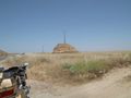
This time I stopped on the way to take a photo of...
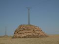
... this funny artificial hill.
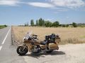
The geohash is 35 meters behind the bike.
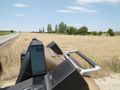
I refrained from stomping through the grain field and left it like that.


