Difference between revisions of "2021-08-20 44 5"
(Added some pictures) |
m (per Renaming Proposal) |
||
| (One intermediate revision by one other user not shown) | |||
| Line 33: | Line 33: | ||
== Tracklog == | == Tracklog == | ||
| − | + | {{tracklog | 2021-08-20 44 5 tracklog.gpx}} | |
| − | |||
== Photos == | == Photos == | ||
| Line 49: | Line 48: | ||
{{#vardefine:ribbonwidth|800px}} | {{#vardefine:ribbonwidth|800px}} | ||
{{land geohash | latitude = 44 | longitude = 5 | date = 2021-08-20 | name = SastRe.O}} | {{land geohash | latitude = 44 | longitude = 5 | date = 2021-08-20 | name = SastRe.O}} | ||
| − | {{ | + | {{Graticule unlocked | latitude = 44 | longitude = 5 | date = 2021-08-20 | name = SastRe.O}} |
== Other Geohashing Expeditions and Plans on This Day == | == Other Geohashing Expeditions and Plans on This Day == | ||
| Line 55: | Line 54: | ||
{{Location|FR|26}} | {{Location|FR|26}} | ||
| + | {{user categories|user=SastRe.O|foot=5.6}} | ||
[[Category:Expeditions]] | [[Category:Expeditions]] | ||
[[Category:Expeditions with photos]] | [[Category:Expeditions with photos]] | ||
[[Category:Coordinates reached]] | [[Category:Coordinates reached]] | ||
| − | |||
| − | |||
| − | |||
| − | |||
| − | |||
| − | |||
| − | |||
| − | |||
| − | |||
| − | |||
| − | |||
| − | |||
| − | |||
| − | |||
| − | |||
| − | |||
| − | |||
| − | |||
| − | |||
Latest revision as of 04:46, 20 March 2024
| Fri 20 Aug 2021 in 44,5: 44.3865472, 5.0464257 geohashing.info google osm bing/os kml crox |
Location
Between vineyards south of Saint-Pantaléon-les-Vignes, France.
Participants
Plans
On my last full day I was spending in this area, I had the luck that the hash fell on a close and rather accessible area. It seems to be between vineyards (what else?) and a path seems close.
So after telling the others my intentions and warning them that there is nothing of interest there (well, it's a matter of opinion), maybe a hidden chapel, we agreed that they would drop me off there, they would visit something else of their taste and then they would pick me up after. Everybody was happy.
I think my parents are loosing track of my GPS-based hobbies. "So, are you looking for a box there?", "No, it's not geocaching, just some random coordinates the internet told me to reach"... **confusion face**. "And... nothing else?", "Nope, just some proof that I have been there.". Ok...
Expedition
So I was dropped off on a parking place with at least some shade. This last week we've reached 41ºC, today only 33ºC (: It's manageable. Lucky me, the path I took was partially going through forest. Ahead there was a couple, but didn't seem like hashers, since they took another path.
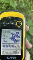
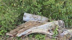
On the vineyard there was a path around it, which I took. Then between the two of them I started the final approach. While battling with some undergrowth, I realized that I never checked the topography of the area, assuming it was completely flat. But if the hash had fell only a few meters to the west, I would have never reached it. It was not the case. After some dancing I got a precise reading of the coordinates.
Happy and satisfied enjoyed a little while the surroundings, and then I continued to a nearby little chapel hidden in the forest. It seemed abandoned. Quite an interesting lost place. Typical geohashing place I would have never known about if I weren't questing after the randomness.
After that I went the same path back. Once at the parking spot from the beginning, I took an avenue to the village where I was picked up again by my family, having succeeded on reaching the coordinates.
Tracklog
Photos
More later
|
Achievements
SastRe.O earned the Land geohash achievement
|
SastRe.O earned the Graticule Unlocked Achievement
|
Other Geohashing Expeditions and Plans on This Day
Expeditions and Plans
| 2021-08-20 | ||
|---|---|---|
| Traralgon, Australia | Mdixon4 | A few metres into a paddock on the side of a Strzelecki hill. |
| Carpentras, France | SastRe.O | Between vineyards south of Saint-Pantaléon-les-Vignes, France. |

