Difference between revisions of "2021-09-18 48 7"
m (Location) |
(Expedition completed) |
||
| Line 11: | Line 11: | ||
== Expedition == | == Expedition == | ||
| + | I left home at 13:15 and cycled from Sélestat to Wintzenheim on the EuroVelo 5. In Wintzenheim, I took the VV21 a cycle route that connects Colmar to the valley of Munster. It's a quiet and easy path with a nice view on the mountains and I met a lot of cyclists until I reached Luttenbach-près-Colmar. There I started climbing the road toward the ''Col du Petit Ballon'' mountain pass. After a few kilometers, I left the road and took a forest path that led me to a hamlet named Stemlisberg. | ||
| + | |||
| + | The coordinates were located in a small meadow surrounded by trees, a 100 meters from the hamlet. I arrived at 16:00 exactly, which is quite fortunate, considering the fact that I had completely forgotten about [[Saturday meetup]] when planning the expedition. | ||
| + | |||
| + | After recording proof, I went back down to the valley and stopped in Munster to eat an ice cream, before heading back to Sélestat. I arrived home at 19:45, after a 105 km bicycle ride. | ||
| + | |||
| + | == Photos == | ||
| + | <gallery> | ||
| + | Image:2021-09-18 48 7 01.jpg | Cycling through Munster valley | ||
| + | Image:2021-09-18 48 7 02.jpg | A little bit of climbing | ||
| + | Image:2021-09-18 48 7 03.jpg | In the forest | ||
| + | Image:2021-09-18 48 7 04.jpg | Bicycle near the geohash | ||
| + | Image:2021-09-18 48 7 05.png | Coordinates reached | ||
| + | Image:2021-09-18 48 7 06.jpg | Surroundings (South) | ||
| + | Image:2021-09-18 48 7 07.jpg | Surroundings (East) | ||
| + | Image:2021-09-18 48 7 08.jpg | Stupid grin | ||
| + | Image:2021-09-18 48 7 09.jpg | On my way back home | ||
| + | </gallery> | ||
== Achievements == | == Achievements == | ||
| Line 25: | Line 43: | ||
| date = 2021-09-18 | | date = 2021-09-18 | ||
| name = [[User:Baarde|Baarde]] | | name = [[User:Baarde|Baarde]] | ||
| − | | distance = | + | | distance = 105 km |
| bothways = true | | bothways = true | ||
}} | }} | ||
| Line 35: | Line 53: | ||
__NOTOC__ | __NOTOC__ | ||
[[Category:Expeditions]] | [[Category:Expeditions]] | ||
| + | [[Category:Expeditions with photos]] | ||
| + | [[Category:Coordinates reached]] | ||
{{location|FR|68}} | {{location|FR|68}} | ||
Revision as of 11:39, 19 September 2021
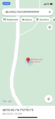
| Sat 18 Sep 2021 in 48,7: 48.0125316, 7.1221371 geohashing.info google osm bing/os kml crox |
Location
In a small meadow, in the mountain above Luttenbach-près-Munster.
Participants
Expedition
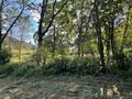
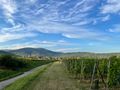
I left home at 13:15 and cycled from Sélestat to Wintzenheim on the EuroVelo 5. In Wintzenheim, I took the VV21 a cycle route that connects Colmar to the valley of Munster. It's a quiet and easy path with a nice view on the mountains and I met a lot of cyclists until I reached Luttenbach-près-Colmar. There I started climbing the road toward the Col du Petit Ballon mountain pass. After a few kilometers, I left the road and took a forest path that led me to a hamlet named Stemlisberg.
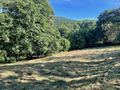
The coordinates were located in a small meadow surrounded by trees, a 100 meters from the hamlet. I arrived at 16:00 exactly, which is quite fortunate, considering the fact that I had completely forgotten about Saturday meetup when planning the expedition.
After recording proof, I went back down to the valley and stopped in Munster to eat an ice cream, before heading back to Sélestat. I arrived home at 19:45, after a 105 km bicycle ride.
Photos
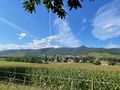
Cycling through Munster valley
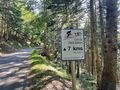
A little bit of climbing
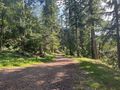
In the forest
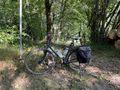
Bicycle near the geohash
Coordinates reached
Surroundings (South)
Surroundings (East)
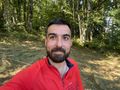
Stupid grin
On my way back home


Achievements
Baarde earned the Land geohash achievement
|
Baarde earned the Bicycle geohash achievement
|
Baarde earned the xkcd Nullaturion achievement
|