Difference between revisions of "2021-09-19 50 7"
m |
Gefrierbrand (talk | contribs) m (→Photos) |
||
| (10 intermediate revisions by 3 users not shown) | |||
| Line 1: | Line 1: | ||
| − | + | {{meetup graticule | |
| − | |||
| − | |||
| − | |||
| − | |||
| − | |||
| − | |||
| − | |||
| − | |||
| lat=50 | | lat=50 | ||
| lon=7 | | lon=7 | ||
| date=2021-09-19 | | date=2021-09-19 | ||
| − | }} | + | }} |
__NOTOC__ | __NOTOC__ | ||
== Location == | == Location == | ||
| − | + | Near St. Lambertus church in Morshausen | |
== Participants == | == Participants == | ||
| − | + | * [[User:Gefrierbrand|Gefrierbrand]] | |
| − | + | * [[User:Santu|Santu]] | |
| + | * Olaf (the pilot) | ||
== Plans == | == Plans == | ||
| − | + | Fly over the hashpoint | |
== Expedition == | == Expedition == | ||
| − | + | We had booked a sight-seeing flight from a nearby municipal airport quite some time ago and now finally had the opportunity to actually go along with it. We had chartered the plane for an hour and were anxiously awaiting the geoashing coordinates and hoped they would fall within the reachable distance and not in some no-fly zone or anything like that. We intended to prioritize sight-seeing over geohashing in any case. But we were very lucky, the hashlocation was not only quickly reachable by plane, it was also located right on a church which could be easily spotted from the air and made it easy to aim for the hash. | |
| + | |||
| + | As we entered the plane, our friendly pilot Olaf asked where we'd like to go and we quickly explained that "the internet" wants us to go to some random location. He quickly created a navpoint in the planes onboard computers and proceeded to takeoff. It took only a few minutes to travel towards the hash and about 3 km in front of the location Olaf spotted the church and kindly aimed directly towards it. With a ground speed of approximately 250 km/h it was hard to capture the exact moment of closest approach, but we managed to get a screenshot which shows us well within the required 310 meters. | ||
| + | After that we enjoyed the remaining 55 minutes of flying above and mostly below the clouds looking down on some of the famous castles and other points of interest in the area. Among others, we flew over the famous Castle Eltz, visited the former volcano-crater which is now Lake Laach and saw fast cars speeding along the Nürburgring before we returned to Koblenz where Rhine and Moselle meet at the "Deutsches Eck" (German corner) and savely landed in Winningen near some former hash expeditions. | ||
== Tracklog == | == Tracklog == | ||
| − | + | {{tracklog | T2021-09-19-14-12 gh flight.gpx}} | |
== Photos == | == Photos == | ||
| − | |||
| − | |||
| − | |||
<gallery perrow="5"> | <gallery perrow="5"> | ||
Image:2021-09-19 50-7 Plane.JPG|"Our" plane | Image:2021-09-19 50-7 Plane.JPG|"Our" plane | ||
Image:2021-09-19 50-7 Rolling Shutter.JPG|Rolling shutter in action | Image:2021-09-19 50-7 Rolling Shutter.JPG|Rolling shutter in action | ||
| − | Image:2021-09-19 50-7 Grin.JPG|StupidGrin | + | Image:2021-09-19 50-7 Grin.JPG|StupidGrin<sup>TM</sup> |
| + | Image:2021-09-19 50-7 Eltz.JPG|Castle Eltz from afar ... | ||
| + | Image:2021_09_19 50 7 eltz.JPG|... and Castle Eltz uplclose | ||
| + | Image:2021-09-19 50-7 Deutsches Eck .jpg|Deutsches Eck | ||
| + | Image:2021_09_19 50 7 ring.JPG|Nürburgring | ||
| + | Image:2021_09_19 50 7 laach.JPG|Lake Laach and Maria Laach Abbey | ||
Image:2021-09-19_50_7_Gefrierbrand_1632066792911.jpg|Proof | Image:2021-09-19_50_7_Gefrierbrand_1632066792911.jpg|Proof | ||
| − | |||
| − | |||
</gallery> | </gallery> | ||
== Achievements == | == Achievements == | ||
{{#vardefine:ribbonwidth|800px}} | {{#vardefine:ribbonwidth|800px}} | ||
| − | + | {{air geohash | |
| − | + | | latitude = 50 | |
| − | + | | longitude = 7 | |
| − | + | | date = 2021-09-19 | |
| − | + | | name = Santu & Gefrierbrand | |
| − | + | | vehicle = plane | |
| − | + | }} | |
| − | + | {{holy hash | |
| − | + | | latitude = 50 | |
| − | + | | longitude = 7 | |
| − | + | | date = 2021-09-19 | |
| − | + | | name = Santu & Gefrierbrand | |
| + | | description = the St. Lambertus catholic church | ||
| + | }} | ||
| − | |||
| − | |||
| − | |||
[[Category:Expeditions]] | [[Category:Expeditions]] | ||
| − | |||
[[Category:Expeditions with photos]] | [[Category:Expeditions with photos]] | ||
| − | |||
| − | |||
| − | |||
| − | |||
| − | |||
[[Category:Coordinates reached]] | [[Category:Coordinates reached]] | ||
| − | + | {{location|DE|RP|GOA}} | |
| − | |||
| − | |||
| − | |||
| − | |||
| − | |||
| − | |||
| − | |||
| − | |||
| − | |||
| − | |||
| − | |||
| − | |||
| − | |||
| − | |||
| − | |||
| − | |||
| − | |||
Latest revision as of 13:02, 20 September 2021
| Sun 19 Sep 2021 in 50,7: 50.1906191, 7.4397067 geohashing.info google osm bing/os kml crox |
Location
Near St. Lambertus church in Morshausen
Participants
- Gefrierbrand
- Santu
- Olaf (the pilot)
Plans
Fly over the hashpoint
Expedition
We had booked a sight-seeing flight from a nearby municipal airport quite some time ago and now finally had the opportunity to actually go along with it. We had chartered the plane for an hour and were anxiously awaiting the geoashing coordinates and hoped they would fall within the reachable distance and not in some no-fly zone or anything like that. We intended to prioritize sight-seeing over geohashing in any case. But we were very lucky, the hashlocation was not only quickly reachable by plane, it was also located right on a church which could be easily spotted from the air and made it easy to aim for the hash.
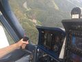
As we entered the plane, our friendly pilot Olaf asked where we'd like to go and we quickly explained that "the internet" wants us to go to some random location. He quickly created a navpoint in the planes onboard computers and proceeded to takeoff. It took only a few minutes to travel towards the hash and about 3 km in front of the location Olaf spotted the church and kindly aimed directly towards it. With a ground speed of approximately 250 km/h it was hard to capture the exact moment of closest approach, but we managed to get a screenshot which shows us well within the required 310 meters.
After that we enjoyed the remaining 55 minutes of flying above and mostly below the clouds looking down on some of the famous castles and other points of interest in the area. Among others, we flew over the famous Castle Eltz, visited the former volcano-crater which is now Lake Laach and saw fast cars speeding along the Nürburgring before we returned to Koblenz where Rhine and Moselle meet at the "Deutsches Eck" (German corner) and savely landed in Winningen near some former hash expeditions.
Tracklog
Photos
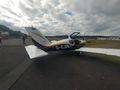
"Our" plane
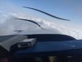
Rolling shutter in action
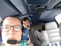
StupidGrinTM
Castle Eltz from afar ...
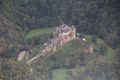
... and Castle Eltz uplclose
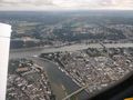
Deutsches Eck
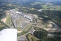
Nürburgring
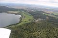
Lake Laach and Maria Laach Abbey

Proof


Achievements
Santu & Gefrierbrand earned the Air geohash achievement
|
Santu & Gefrierbrand earned the Holy hash achievement
|