Difference between revisions of "2021-10-08 -38 146"
(→Tracklog) |
m (Location) |
||
| (4 intermediate revisions by 2 users not shown) | |||
| Line 25: | Line 25: | ||
<!-- how it all turned out. your narrative goes here. --> | <!-- how it all turned out. your narrative goes here. --> | ||
| − | It was not far from the hash I reached on 2021-08-20, and my route would be the same until I reached the Grand Ridge Road, where instead of turning right I'd turn left. | + | It was not far from the hash I reached on [[2021-08-20_-38_146|2021-08-20]], and my route would be the same until I reached the Grand Ridge Road, where instead of turning right I'd turn left. |
Well, one other difference. It was too early to detour to Thorpdale for the pies, so I stayed on McDonalds Track, which takes one past the <s>World's Tallest Tree.</s> <s>''Site of'' the World's Tallest Tree.</s> <s>Monument ''near'' the site of the World's Tallest Tree.</s> <s>Monument near the site of the World's Tallest ''Flowering'' Tree.</s> Monument near the site of the World's Tallest Flowering Tree ''That's Been Measured By A Licensed Surveyor''. It was cut down in the 1880s, measured, found to be quite tall (long, really, by now) and a plaque was put up nearby (not actually at the site) almost 100 years later. | Well, one other difference. It was too early to detour to Thorpdale for the pies, so I stayed on McDonalds Track, which takes one past the <s>World's Tallest Tree.</s> <s>''Site of'' the World's Tallest Tree.</s> <s>Monument ''near'' the site of the World's Tallest Tree.</s> <s>Monument near the site of the World's Tallest ''Flowering'' Tree.</s> Monument near the site of the World's Tallest Flowering Tree ''That's Been Measured By A Licensed Surveyor''. It was cut down in the 1880s, measured, found to be quite tall (long, really, by now) and a plaque was put up nearby (not actually at the site) almost 100 years later. | ||
| Line 47: | Line 47: | ||
Image:2020-##-## ## ## Alpha.jpg | Witty Comment | Image:2020-##-## ## ## Alpha.jpg | Witty Comment | ||
--> | --> | ||
| − | <gallery | + | <gallery> |
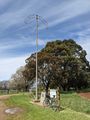
| + | File:PXL_20211008_021010847.jpg | Site of the world's tallest tree | ||
| + | File:PXL_20211008_025132097.jpg | Friendly chaps | ||
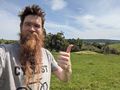
| + | File:PXL_20211008_025640235.jpg | At the hash | ||
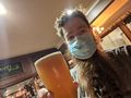
| + | File:PXL_20211008_033017497.jpg | Supporting the local economy | ||
| + | File:PXL_20211008_045330385.jpg | The route home from the brewery, another beaut road. | ||
| + | File:Screenshot_20211008-135605.png | proof! | ||
</gallery> | </gallery> | ||
| Line 54: | Line 60: | ||
<!-- Add any achievement ribbons you earned below, or remove this section --> | <!-- Add any achievement ribbons you earned below, or remove this section --> | ||
| − | |||
| − | |||
| − | |||
| − | |||
| − | |||
| − | |||
| − | |||
| − | |||
| − | |||
| − | |||
| − | |||
| − | |||
| − | |||
| − | |||
[[Category:Expeditions]] | [[Category:Expeditions]] | ||
| − | |||
[[Category:Expeditions with photos]] | [[Category:Expeditions with photos]] | ||
| − | |||
| − | |||
| − | |||
| − | |||
| − | |||
[[Category:Coordinates reached]] | [[Category:Coordinates reached]] | ||
| − | + | {{location|AU|VIC|SL}} | |
| − | |||
| − | |||
| − | |||
| − | |||
| − | |||
| − | |||
| − | |||
| − | |||
| − | |||
| − | |||
| − | |||
| − | |||
| − | |||
| − | |||
| − | |||
| − | |||
| − | |||
Latest revision as of 18:42, 19 October 2021
| Fri 8 Oct 2021 in -38,146: -38.3808659, 146.1107275 geohashing.info google osm bing/os kml crox |
Location
A muddy paddock by the Grand Ridge Road near Allambee South.
Participants
Expedition
It was not far from the hash I reached on 2021-08-20, and my route would be the same until I reached the Grand Ridge Road, where instead of turning right I'd turn left.
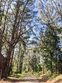
Well, one other difference. It was too early to detour to Thorpdale for the pies, so I stayed on McDonalds Track, which takes one past the World's Tallest Tree. Site of the World's Tallest Tree. Monument near the site of the World's Tallest Tree. Monument near the site of the World's Tallest Flowering Tree. Monument near the site of the World's Tallest Flowering Tree That's Been Measured By A Licensed Surveyor. It was cut down in the 1880s, measured, found to be quite tall (long, really, by now) and a plaque was put up nearby (not actually at the site) almost 100 years later.
But somehow more remarkable is the magpie conference tree, which happens to have dozens and dozens, maybe more than a hundred magpies in and around it each time I go past. Fortunately they're not aggressive. But I've never seen so many magpies in one place!
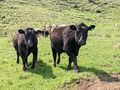
Anyway, turning left on the Grand Ridge Road I climbed out of the valley, hoping the stunning scenery wouldn't distract me from locating the hash. I duly identified the paddock, found a sturdy part of the fence to climb over, and started heading up the hill. The paddock had a herd of young cattle, most very friendly, perhaps wondering if I had treats. Some further up the hill came barelling down at full speed to join the party.
The cattle left me alone once it became obvious I had nothing to give them, and I was able to trudge back and forth to find the coordinates in peace.
Back on the bike, and keen to avoid retracing my steps, I headed onwards into Mirboo North, home of the Grand Ridge Brewery. Always keen to support local businesses, I grabbed a beer while I considered my route home.
I believed I'd have to spend a bit of time on a highway in order to get home from Mirboo North, but consulting the map I found that in fact it was possible to avoid not only highways but all main roads, and a medley of rail trail, forestry track and farm road could get me almost all the way home! This region never fails to deliver!
Tracklog
Photos
Site of the world's tallest tree
Friendly chaps
At the hash
Supporting the local economy
The route home from the brewery, another beaut road.

proof!


