Difference between revisions of "2021-11-07 43 -78"
Pedalpusher (talk | contribs) (New report) |
m (Location) |
||
| (One intermediate revision by one other user not shown) | |||
| Line 17: | Line 17: | ||
Getting over the bridge again, I got a screenshot of the Hash as we drove by and J took a picture on her phone of our view out the front window. I didn't think we'd be able to get a great reading on the Hashdroid app, but from our pictures, it should be pretty clear we still drove through it. Happy to get two hashes without having to get out of the car, we drove back so I could pick up the dogs and head for home. | Getting over the bridge again, I got a screenshot of the Hash as we drove by and J took a picture on her phone of our view out the front window. I didn't think we'd be able to get a great reading on the Hashdroid app, but from our pictures, it should be pretty clear we still drove through it. Happy to get two hashes without having to get out of the car, we drove back so I could pick up the dogs and head for home. | ||
| − | It wasn't until I was writing up the report and confirming the coordinates that I realized this wasn't the Toronto hash, but the Lockport hash. I may have gotten a little over-excited thinking it was the | + | Technically, this might be a Speed Racer, but I don't have a recording of our speed as we drove through. Also, from the street-view, it looks like the Speed Limit changed from 55 to 65 MPH right at the hash so it would be a tough feat to determine which side of the line it was on anyway. |
| + | |||
| + | It wasn't until I was writing up the report and confirming the coordinates that I realized this wasn't the Toronto hash, but the Lockport hash. I may have gotten a little over-excited thinking it was the one I needed and there aren't the graticule lines on the HashDroid app for reference. Still, it's exciting to get a Double Hash and I'll keep watching for that elusive Toronto hash invading the U.S. and landing on Grand Island. | ||
== Photos == | == Photos == | ||
| − | <gallery perrow=" | + | <gallery perrow="6"> |
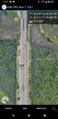
| − | Image: | + | Image:2021-11-07 Pt2 hashView1.jpg| With J driving this time, I took a picture of the hash as we drove north to get off the Island and turn around. The Hash is between the signs on the other side of the road. |
| − | Image: | + | Image:2021-11-07 Pt2 downRiver.jpg| Driving over the Northern bridges, this is a boring view East and Downriver. Grand Island is on the right and the mainland is to the left. |
| − | Image: | + | Image:2021-11-07 Pt2 niagaraFalls.jpg| Now heading South toward the hash, you can see both cities of Niagara Falls on the right (if you know what you're looking for). |
| − | Image: | + | Image:2021-11-07 Pt2 hashView2.jpg| J managed to get a picture as we were driving right through the hash. |
| − | Image: | + | Image:2021-11-07 Pt2 hashDroid.png| Closest reading we got on the Hashdroid app. Going so fast, the updates were about 200 feet(60 meters) apart. But clearly we drove through the hash. |
| − | Image: | + | Image:2021-11-07 Pt2 stupidGrins.jpg| Some really Stupid Grins, a bit down the road. |
| − | |||
</gallery> | </gallery> | ||
| Line 42: | Line 43: | ||
}} | }} | ||
| − | |||
[[Category:Expeditions]] | [[Category:Expeditions]] | ||
[[Category:Coordinates reached]] | [[Category:Coordinates reached]] | ||
| − | + | [[Category:Expeditions with photos]] | |
| + | {{location|US|NY|ER}} | ||
Latest revision as of 17:42, 11 November 2021
| Sun 7 Nov 2021 in 43,-78: 43.0569274, -78.9906196 geohashing.info google osm bing/os kml crox |
Location
Middle of I-190 S on Grand Island, near the North bridges
Participants
Expedition
This is Part 2 of a Multi-Hash. You can view Part 1 here.
I was pretty excited to try for this one as I thought it was an extremely rare instance of a Toronto Hash landing on the U.S. side. Even more rare would be to see it on Grand Island where I'm working on my Regional geohashing achievement.
Getting back to the outskirts of Buffalo, we picked up J's car and headed for her apartment in Tonawanda where we were going to drop off the dogs and drive to Grand Island. She only lives about 5 minutes away from the Island and it wasn't very long to get across to the other side. As we drove by on I-190 Northbound, I tried to get a few pictures of the hash area on the Southbound side. Once off the Island, we turned around and headed back to drive through the hash.
Getting over the bridge again, I got a screenshot of the Hash as we drove by and J took a picture on her phone of our view out the front window. I didn't think we'd be able to get a great reading on the Hashdroid app, but from our pictures, it should be pretty clear we still drove through it. Happy to get two hashes without having to get out of the car, we drove back so I could pick up the dogs and head for home.
Technically, this might be a Speed Racer, but I don't have a recording of our speed as we drove through. Also, from the street-view, it looks like the Speed Limit changed from 55 to 65 MPH right at the hash so it would be a tough feat to determine which side of the line it was on anyway.
It wasn't until I was writing up the report and confirming the coordinates that I realized this wasn't the Toronto hash, but the Lockport hash. I may have gotten a little over-excited thinking it was the one I needed and there aren't the graticule lines on the HashDroid app for reference. Still, it's exciting to get a Double Hash and I'll keep watching for that elusive Toronto hash invading the U.S. and landing on Grand Island.
Photos
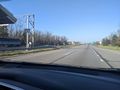
With J driving this time, I took a picture of the hash as we drove north to get off the Island and turn around. The Hash is between the signs on the other side of the road.
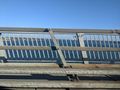
Driving over the Northern bridges, this is a boring view East and Downriver. Grand Island is on the right and the mainland is to the left.
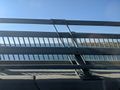
Now heading South toward the hash, you can see both cities of Niagara Falls on the right (if you know what you're looking for).
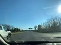
J managed to get a picture as we were driving right through the hash.
Closest reading we got on the Hashdroid app. Going so fast, the updates were about 200 feet(60 meters) apart. But clearly we drove through the hash.
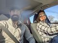
Some really Stupid Grins, a bit down the road.


Ribbons
This user earned the Land geohash achievement
|
Pedalpusher and J earned the Multihash Achievement
|