Difference between revisions of "2021-12-05 52 10"
From Geohashing
m (user categories) |
m (Adding hours) |
||
| Line 32: | Line 32: | ||
[[Category:Expeditions with photos]] | [[Category:Expeditions with photos]] | ||
{{location|DE|NI|PE}} | {{location|DE|NI|PE}} | ||
| − | {{user categories|user=Fippe|bike=10|train=109|foot=8}} | + | {{user categories|user=Fippe|bike=10|train=109|foot=8|hours=09}} |
Latest revision as of 19:49, 11 December 2022
| Sun 5 Dec 2021 in 52,10: 52.1961861, 10.3607541 geohashing.info google osm bing/os kml crox |
Location
This Geohash is located on a field in Lengede.
Participants
Expedition
I cycled to Messe/Laatzen, took the train to Lengede-Broistedt and walked the rest of the distance from there.
A long stretch of my way was a street without a footpath, so I had to walk on the street. But since it wasn't dark, it was okay. A smaller path eventually split from the road to lead me to the site. Once I arrived at the field, I was able to locate the coordinates and record proof.
Afterwards, I walked back to the station and took the train back. This has been my 1000000002th expedition, counting not-reached points but not retros.
Photos

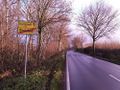
Leaving Broistedt
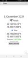
Proof
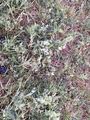
The Geohash
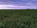
The site of the Geohash


Achievements
Fippe earned the Land geohash achievement
|

Fippe earned the Two to the N achievement
by attempting to reach 28 hashpoints on 2021-12-05 52 10 and is promoted to Level 8 (Expeditions).