Difference between revisions of "2021-12-11 50 19"
m (Location) |
(finishing) |
||
| Line 23: | Line 23: | ||
== Photos == | == Photos == | ||
| − | |||
| − | |||
| − | |||
<gallery perrow="5"> | <gallery perrow="5"> | ||
| + | Image:2021-12-11 50-19 photo1.jpg | Driving to the hashpoint | ||
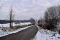
| + | Image:2021-12-11_50-19_photo2.jpg | Time to leave the car | ||
| + | Image:2021-12-11_50-19_photo3.jpg | Hashpoint view from a far | ||
| + | Image:2021-12-11_50-19_photo4.jpg | Signpost at the sharp turn | ||
| + | Image:2021-12-11_50-19_photo5.jpg | Walking to the hashpoint | ||
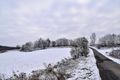
| + | Image:2021-12-11_50-19_photo6.jpg | At the meadow | ||
| + | Image:2021-12-11 50-19 photo7.jpg | Found it! | ||
| + | Image:2021-12-11_50-19_photo8.jpg | View from the hashpoint (marked with a trekking stick) | ||
| + | Image:2021-12-11-50-19-proof.png | Proof | ||
</gallery> | </gallery> | ||
== Achievements == | == Achievements == | ||
{{#vardefine:ribbonwidth|800px}} | {{#vardefine:ribbonwidth|800px}} | ||
| − | + | {{Two to the N achievement | |
| + | | count = 3 | ||
| + | | date = 2021-12-11 | ||
| + | | latitude = 50 | ||
| + | | longitude = 19 | ||
| + | | name = [[User:Zyxist|Zyxist]] | ||
| + | | reached = true | ||
| + | }} | ||
[[Category:Expeditions]] | [[Category:Expeditions]] | ||
Revision as of 14:48, 11 December 2021
| Sat 11 Dec 2021 in 50,19: 50.2354822, 19.8316492 geohashing.info google osm bing/os kml crox |
Location
Small meadow on a hill near Skała town, 25 km north of Kraków.
Participants
Zyxist alone
Plans
Geohashing in winter wonderland. Reality exceeded expectations.
Expedition
It would be a great biking expedition, if not winter. Areas around Kraków are on much higher elevation and the snow cover is greater there. The question is: will the weather cooperate?
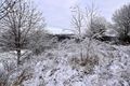
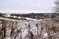
I departed from home around 1:00 PM. I took the road going straight north from the city, climbing higher and higher. Suddenly, the dense fog (and air pollution from chimneys) appeared and I started worrying whether there will be anything to see. Fortunately, once I entered the ring road around Skała, the fog was gone and uncovered excellent views. I circled the town and turned into a small, village road. At the sharp turn, I found a ground road going to the forest and decided to park there. I walked the last 200 meters, and entered the meadow. After covering some bushes and snow, I found the hashpoint. It was probably my first hashpoint with such a nice view. There was a valley and the town on a hill. I spent some time there and I walked back to the car.
Tracklog
Photos
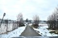
Driving to the hashpoint

Time to leave the car
Hashpoint view from a far
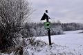
Signpost at the sharp turn
Walking to the hashpoint
At the meadow
Found it!
View from the hashpoint (marked with a trekking stick)
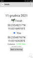
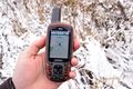
Proof


Achievements
