Difference between revisions of "2022-01-15 37 -122"
(create 2022-01-15 37 -122) |
m (Location) |
||
| (2 intermediate revisions by one other user not shown) | |||
| Line 1: | Line 1: | ||
| − | + | {{meetup graticule | |
| − | |||
| − | |||
| − | |||
| − | |||
| − | |||
| − | |||
| − | |||
| − | |||
| lat={{#explode:{{SUBPAGENAME}}| |1}} | | lat={{#explode:{{SUBPAGENAME}}| |1}} | ||
| lon={{#explode:{{SUBPAGENAME}}| |2}} | | lon={{#explode:{{SUBPAGENAME}}| |2}} | ||
| date={{#explode:{{SUBPAGENAME}}| |0}} | | date={{#explode:{{SUBPAGENAME}}| |0}} | ||
| − | }} | + | }} |
__NOTOC__ | __NOTOC__ | ||
== Location == | == Location == | ||
| − | + | Within the Bear Creek Redwoods Open Space Preserve, at the far right edge of the graticule. | |
== Participants == | == Participants == | ||
| − | + | * [[User:sporeball|sporeball]] | |
| − | |||
== Plans == | == Plans == | ||
| − | + | The hashpoint was just off of Bear Creek Road within the Bear Creek Redwoods Open Space Preserve near Los Gatos, and so close to the border between the [[San Francisco, California|San Francisco]] and [[San Jose, California|San Jose]] graticules that my mother agreed to drive me there. After getting lunch at our local Olive Garden, we set off. | |
== Expedition == | == Expedition == | ||
| − | + | The drive was fairly straightforward — a bit windy towards the end, perhaps, but otherwise fine. We parked in the Bear Creek Redwoods parking lot at around 1:30 PM; my original thought was to diverge from the nearby Alma Trail, but after my mother convinced me that that was ''not'' what I wanted to do, we drove along Bear Creek Road until I faced the hashpoint, instead. At 1:43 PM, I hopped out and began trekking through the brush to the side. | |
| − | + | After ten minutes, I was surrounded by plant life on all sides, but had reached a point which minimized Google Maps' margin of error — and with only minimal scrapes to boot! Having not been warned off by any posted signs, I counted this as my first successful geohash, and took a picture of my [[stupid grin]] (well, smile). | |
| − | |||
== Photos == | == Photos == | ||
| − | |||
| − | |||
| − | |||
<gallery perrow="5"> | <gallery perrow="5"> | ||
| + | Image:2022 01 15 37 -122 proof.png | Proof of my location. | ||
| + | Image:2022 01 15 37 -122 brush.jpeg | Brush on all sides. | ||
| + | Image:2022 01 15 37 -122 grin.jpeg | Stupid "grin"! | ||
</gallery> | </gallery> | ||
== Achievements == | == Achievements == | ||
{{#vardefine:ribbonwidth|800px}} | {{#vardefine:ribbonwidth|800px}} | ||
| − | + | {{Land geohash | |
| − | + | | latitude = 37 | |
| − | + | | longitude = -122 | |
| − | + | | date = 2022-01-15 | |
| − | + | | name = sporeball | |
| + | }} | ||
| + | {{Two to the N achievement | ||
| + | | count = 0 | ||
| + | | latitude = 37 | ||
| + | | longitude = -122 | ||
| + | | date = 2022-01-15 | ||
| + | | reached = true | ||
| + | | name = sporeball | ||
| + | }} | ||
| − | |||
| − | |||
| − | |||
| − | |||
| − | |||
| − | |||
| − | |||
| − | |||
| − | |||
| − | |||
[[Category:Expeditions]] | [[Category:Expeditions]] | ||
| − | + | [[Category:Expeditions with photos]] | |
| − | [[Category:Expeditions with photos]] | ||
| − | |||
| − | |||
| − | |||
| − | |||
| − | |||
[[Category:Coordinates reached]] | [[Category:Coordinates reached]] | ||
| − | + | {{location|US|CA|SL}} | |
| − | |||
| − | |||
| − | |||
| − | |||
| − | |||
| − | |||
| − | |||
| − | |||
| − | |||
| − | |||
| − | |||
| − | |||
| − | |||
| − | |||
| − | |||
| − | |||
| − | |||
Latest revision as of 00:42, 16 January 2022
| Sat 15 Jan 2022 in 37,-122: 37.1806112, -122.0036901 geohashing.info google osm bing/os kml crox |
Location
Within the Bear Creek Redwoods Open Space Preserve, at the far right edge of the graticule.
Participants
Plans
The hashpoint was just off of Bear Creek Road within the Bear Creek Redwoods Open Space Preserve near Los Gatos, and so close to the border between the San Francisco and San Jose graticules that my mother agreed to drive me there. After getting lunch at our local Olive Garden, we set off.
Expedition
The drive was fairly straightforward — a bit windy towards the end, perhaps, but otherwise fine. We parked in the Bear Creek Redwoods parking lot at around 1:30 PM; my original thought was to diverge from the nearby Alma Trail, but after my mother convinced me that that was not what I wanted to do, we drove along Bear Creek Road until I faced the hashpoint, instead. At 1:43 PM, I hopped out and began trekking through the brush to the side.
After ten minutes, I was surrounded by plant life on all sides, but had reached a point which minimized Google Maps' margin of error — and with only minimal scrapes to boot! Having not been warned off by any posted signs, I counted this as my first successful geohash, and took a picture of my stupid grin (well, smile).
Photos

Proof of my location.
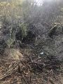
Brush on all sides.

Stupid "grin"!


Achievements
sporeball earned the Land geohash achievement
|
