Difference between revisions of "2022-01-30 40 -4"
(→Tracklog) |
(→Tracklog) |
||
| Line 39: | Line 39: | ||
Image:2022-01-30_40_-4_track_map.png | The track visualized by GPS Visualizer. | Image:2022-01-30_40_-4_track_map.png | The track visualized by GPS Visualizer. | ||
Image:2022-01-30_40_-4_x_y.png | My plot with x and y distances from the geohash, which is the green spot at the origin. | Image:2022-01-30_40_-4_x_y.png | My plot with x and y distances from the geohash, which is the green spot at the origin. | ||
| − | Image:2022-01-30_40_- | + | Image:2022-01-30_40_-4_track_t_d.png | Distance from the geohash vs. time. |
Image:2022-01-30_40_-4_L1040950.JPG | Mounting the GoPro on the Helmet. | Image:2022-01-30_40_-4_L1040950.JPG | Mounting the GoPro on the Helmet. | ||
Image:2022-01-30_40_-4_L1040951.JPG | It's a Hero 3, so you can tell I have it for quite some time. | Image:2022-01-30_40_-4_L1040951.JPG | It's a Hero 3, so you can tell I have it for quite some time. | ||
Revision as of 16:01, 31 January 2022
| Sun 30 Jan 2022 in 40,-4: 40.8994948, -4.1339561 geohashing.info google osm bing/os kml crox |
Location
Directly on the southbound lane of the SG-V-7212 near Segovia.
Participants
Plans
Expedition
Tracklog
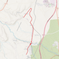
The track visualized by GPS Visualizer.
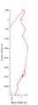
My plot with x and y distances from the geohash, which is the green spot at the origin.
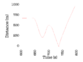
Distance from the geohash vs. time.
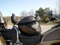
Mounting the GoPro on the Helmet.
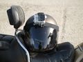
It's a Hero 3, so you can tell I have it for quite some time.


Photos
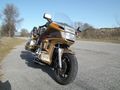
Getting ready for the Speed racer achievement. Still 2 km to go to the geohash.
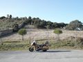
The parking space is next to the Palacio y bosque de Riofrío (to the left of the wall).
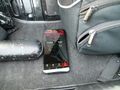
Starting the GPS Logger.
Mounting the GoPro on the Helmet.
It's a Hero 3, so you can tell I have it for quite some time.


Videos
The geohash is ridden through at 2:38. The total length of the video is 8:37, with cornering through tight serpentines 5:00-7:00, followed by a ride through a small village.
Achievements
