Difference between revisions of "2022-01-30 40 -4"
From Geohashing
(→Tracklog) |
(→Tracklog) |
||
| Line 35: | Line 35: | ||
<!-- if your GPS device keeps a log, you may post a link | <!-- if your GPS device keeps a log, you may post a link | ||
here --> | here --> | ||
| + | |||
| + | {{Tracklog|2022-01-30_40_-4_track.gpx}} | ||
<gallery perrow="5"> | <gallery perrow="5"> | ||
| − | |||
Image:2022-01-30_40_-4_x_y.png | My plot with x and y distances from the geohash, which is the green spot at the origin. | Image:2022-01-30_40_-4_x_y.png | My plot with x and y distances from the geohash, which is the green spot at the origin. | ||
Image:2022-01-30_40_-4_track_t_d.png | Distance from the geohash vs. time. | Image:2022-01-30_40_-4_track_t_d.png | Distance from the geohash vs. time. | ||
Revision as of 16:14, 31 January 2022
| Sun 30 Jan 2022 in 40,-4: 40.8994948, -4.1339561 geohashing.info google osm bing/os kml crox |
Location
Directly on the southbound lane of the SG-V-7212 near Segovia.
Participants
Plans
Expedition
Tracklog
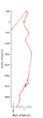
My plot with x and y distances from the geohash, which is the green spot at the origin.
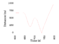
Distance from the geohash vs. time.
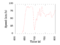
Speed vs. time.
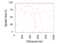
Speed vs. distance from the geohash.


Photos
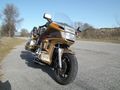
Getting ready for the Speed racer achievement. Still 2 km to go to the geohash.
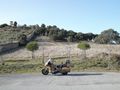
The parking space is next to the Palacio y bosque de Riofrío (to the left of the wall).
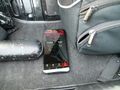
Starting the GPS Logger.
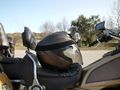
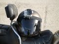
Mounting the GoPro on the Helmet.
It's a Hero 3, so you can tell I have it for quite some time.


Videos
The geohash is ridden through at 2:38. The total length of the video is 8:37, with cornering through tight serpentines 5:00-7:00, followed by a ride through a small village.
Achievements

Wingman earned the Speed racer achievement
by passing through the (40, -4) geohash on 2022-01-30 at 86 km/h.