Difference between revisions of "2022-03-13 50 7"
Gefrierbrand (talk | contribs) ([retro picture]grave injury) |
Gefrierbrand (talk | contribs) |
||
| Line 14: | Line 14: | ||
== Plans == | == Plans == | ||
| − | + | Drive to Boppard, walk some part of the [https://www.saar-hunsrueck-steig.de/en/dreamloops/marienberg dreamloop marienberg] and try to reach the hash if the terrain permits. | |
== Expedition == | == Expedition == | ||
| − | + | The hashlocation was quite near a beautiful hiking route on what appeared to be dubious terrain in the Rhine valleys. We decided we'd give it a go and use the beautiful weather for a nice tour with Pedro, even if the geohashing wouldn't work out. As we did previously on [[2021-05-20 50 7]], we used a very narrow but beautiful road to get to Boppard. | |
| + | |||
| + | We started walking along a nice park and had some fun taking silly pictures. Shortly after that, the steep part started and we had to climb narrow switchbacks which made us wonder why we had brought jackets after-all. | ||
| + | |||
| + | About 3/4 of the way to the top, we suddenly noticed that Pedro was bleeding slightly from his left rear paw! A closer inspection revealed that he must have ripped most of his toe-claw off at some point. As we were quite far away from the next proper road we decided to first continue upwards to reach some car-accessible road and reassess the situation from there. We also pondered finding a veterinarian asap, which would have been very challenging on a Sunday. | ||
| + | |||
| + | Surprisingly, Pedro didn't seem to notice at all and was happily following us (or more accurately, running ahead as he often does). Since the slight bleeding had stopped quickly and Pedro showed no signs of pain, we decided to continue carefully and walked through the forest towards a few vantage points overlooking the Rhine. | ||
| + | |||
| + | As we neared the hashlocation we arrived at the "stone man" viewpoint and started to seriously question whether the hashlocation would be reachable at all as the rockformation was basically completely vertical below us and it were only about 200 m to the hash. Luckily, the terrain quickly got flatter (but was still steep) and we even managed to find a suitable spot to exit the path and venture into the sloped forest. | ||
| + | |||
| + | At first we were unsure if it's a good idea to try to go there so Gefrierbrand carefully went ahead a few meters while Santu stayed back with Pedro. But we were quickly able to find a "good enough" route and continued on the slippery ground towards the hash without major incidents. | ||
| + | |||
| + | As we arrived there, we had a nice picnic where we graciously offered Pedro the bananas initially intended for us as compensation for all the excitement he endures so bravely on our adventures. We then headed back using a lightly different route, Gefrierbrand found some old broken sign just spelling "R" (possibly a broken path-marker) which he carried to the next garbage bin. | ||
| + | |||
| + | Back in Boppard, we rested on a bench with a direct view on some parts of our route of the [[2021-05-20 50 7]] adventure and enjoyed the sun there before trying out exotic ice-cream (wine and peanut, both strange but enjoyable). The wine ice-cream was really soft and sparkling and melting quickly so it qualifies as a squishy. | ||
| + | |||
| + | We then went home, cleaned Pedros wound and decided it was safer to bandage it up for the night and awarded him with a nice bit of hard chewing-cheese. We phoned the vet on the next day and he won't need any treatment and is going to be fine! | ||
== Tracklog == | == Tracklog == | ||
| Line 27: | Line 43: | ||
Image:2022-03-13_50_7_Gefrierbrand_1647278506398.jpg|old expedition path visible | Image:2022-03-13_50_7_Gefrierbrand_1647278506398.jpg|old expedition path visible | ||
Image:2022-03-13_50_7_Gefrierbrand_1647278433290.jpg|Santu in a wood arch | Image:2022-03-13_50_7_Gefrierbrand_1647278433290.jpg|Santu in a wood arch | ||
| − | Image:2022-03-13_50_7_Gefrierbrand_1647278468256.jpg|view from | + | Image:2022-03-13_50_7_Gefrierbrand_1647278468256.jpg|view from "stone man" |
Image:2022-03-13_50_7_Gefrierbrand_1647278408459.jpg|Pedro and Santo pondering at the hash | Image:2022-03-13_50_7_Gefrierbrand_1647278408459.jpg|Pedro and Santo pondering at the hash | ||
Image:2022-03-13_50_7_Gefrierbrand_1647278637234.jpg|Gefrierbrand enjoying lunch at the hashlocation | Image:2022-03-13_50_7_Gefrierbrand_1647278637234.jpg|Gefrierbrand enjoying lunch at the hashlocation | ||
Image:2022-03-13_50_7_Gefrierbrand_1647278389773.jpg|StupidGrin<sup>TM</sup> | Image:2022-03-13_50_7_Gefrierbrand_1647278389773.jpg|StupidGrin<sup>TM</sup> | ||
Image:2022-03-13_50_7_Gefrierbrand_1647278357961.jpg|Brave dog resting after the adventure | Image:2022-03-13_50_7_Gefrierbrand_1647278357961.jpg|Brave dog resting after the adventure | ||
| + | Image:2022-03-13_50_7_Gefrierbrand_1647279514962.jpg|grave injury | ||
Image:2022-03-13_50_7_Gefrierbrand_1647278664748.jpg|bandaged dog | Image:2022-03-13_50_7_Gefrierbrand_1647278664748.jpg|bandaged dog | ||
Image:2022-03-13_50_7_Gefrierbrand_1647177550642.jpg|Proof | Image:2022-03-13_50_7_Gefrierbrand_1647177550642.jpg|Proof | ||
| − | |||
| − | |||
</gallery> | </gallery> | ||
== Achievements == | == Achievements == | ||
{{#vardefine:ribbonwidth|800px}} | {{#vardefine:ribbonwidth|800px}} | ||
| − | + | {{land geohash | |
| − | + | | latitude = 50 | |
| − | + | | longitude = 7 | |
| − | + | | date = 2022-03-13 | |
| − | + | | name = Santu & Gefrierbrand | |
| − | + | }} | |
| − | + | {{Geotrash | |
| − | + | | latitude = 50 | |
| − | + | | longitude = 7 | |
| − | + | | date = 2022-03-13 | |
| − | [ | + | | name = Santu & Gefrierbrand |
| − | -- | + | }} |
| − | + | {{Picnic_geohash | |
| − | + | | latitude = 50 | |
| − | + | | longitude = 7 | |
| − | + | | date = 2022-03-13 | |
| + | | name = Pedro the dog | ||
| + | | food = bananas | ||
| + | }} | ||
| + | {{GeoSquishy FirstSip | ||
| + | | latitude = 50 | ||
| + | | longitude = 7 | ||
| + | | date = 2022-03-13 | ||
| + | | name = Gefrierbrand & Santu | ||
| + | }} | ||
| + | {{Ribbon | ||
| + | |color = red | ||
| + | |icon = TrailofBlood.PNG | ||
| + | |user = Pedro the dog | ||
| + | |achievement = It's only a flesh wound Achievement | ||
| + | |action = continuing on to the [https://geohashing.info/s/2022-03-13/50,7 (50, 7) geohash] on [[2022-03-13 50 7|2022-03-13]] despite loosing a claw | ||
| + | }} | ||
[[Category:Expeditions]] | [[Category:Expeditions]] | ||
| − | |||
[[Category:Expeditions with photos]] | [[Category:Expeditions with photos]] | ||
| − | |||
| − | |||
| − | |||
| − | |||
| − | |||
[[Category:Coordinates reached]] | [[Category:Coordinates reached]] | ||
| − | |||
| − | |||
| − | |||
| − | |||
| − | |||
| − | |||
| − | |||
| − | |||
| − | |||
| − | |||
| − | |||
| − | |||
| − | |||
| − | |||
| − | |||
| − | |||
| − | |||
| − | |||
Revision as of 21:03, 15 March 2022
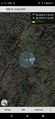
| Sun 13 Mar 2022 in 50,7: 50.2196686, 7.6137547 geohashing.info google osm bing/os kml crox |
Location
Between trees on a slope of the Rhine valley near Boppard
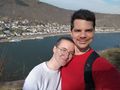
Participants
- Gefrierbrand
- Santu
- Pedro the dog
Plans
Drive to Boppard, walk some part of the dreamloop marienberg and try to reach the hash if the terrain permits.
Expedition
The hashlocation was quite near a beautiful hiking route on what appeared to be dubious terrain in the Rhine valleys. We decided we'd give it a go and use the beautiful weather for a nice tour with Pedro, even if the geohashing wouldn't work out. As we did previously on 2021-05-20 50 7, we used a very narrow but beautiful road to get to Boppard.
We started walking along a nice park and had some fun taking silly pictures. Shortly after that, the steep part started and we had to climb narrow switchbacks which made us wonder why we had brought jackets after-all.
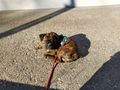
About 3/4 of the way to the top, we suddenly noticed that Pedro was bleeding slightly from his left rear paw! A closer inspection revealed that he must have ripped most of his toe-claw off at some point. As we were quite far away from the next proper road we decided to first continue upwards to reach some car-accessible road and reassess the situation from there. We also pondered finding a veterinarian asap, which would have been very challenging on a Sunday.
Surprisingly, Pedro didn't seem to notice at all and was happily following us (or more accurately, running ahead as he often does). Since the slight bleeding had stopped quickly and Pedro showed no signs of pain, we decided to continue carefully and walked through the forest towards a few vantage points overlooking the Rhine.
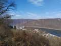
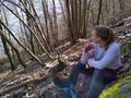
As we neared the hashlocation we arrived at the "stone man" viewpoint and started to seriously question whether the hashlocation would be reachable at all as the rockformation was basically completely vertical below us and it were only about 200 m to the hash. Luckily, the terrain quickly got flatter (but was still steep) and we even managed to find a suitable spot to exit the path and venture into the sloped forest.
At first we were unsure if it's a good idea to try to go there so Gefrierbrand carefully went ahead a few meters while Santu stayed back with Pedro. But we were quickly able to find a "good enough" route and continued on the slippery ground towards the hash without major incidents.
As we arrived there, we had a nice picnic where we graciously offered Pedro the bananas initially intended for us as compensation for all the excitement he endures so bravely on our adventures. We then headed back using a lightly different route, Gefrierbrand found some old broken sign just spelling "R" (possibly a broken path-marker) which he carried to the next garbage bin.
Back in Boppard, we rested on a bench with a direct view on some parts of our route of the 2021-05-20 50 7 adventure and enjoyed the sun there before trying out exotic ice-cream (wine and peanut, both strange but enjoyable). The wine ice-cream was really soft and sparkling and melting quickly so it qualifies as a squishy.
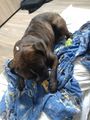
We then went home, cleaned Pedros wound and decided it was safer to bandage it up for the night and awarded him with a nice bit of hard chewing-cheese. We phoned the vet on the next day and he won't need any treatment and is going to be fine!
Tracklog
Photos
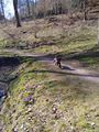
happyly running dog
old expedition path visible
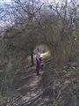
Santu in a wood arch
view from "stone man"
Pedro and Santo pondering at the hash
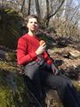
Gefrierbrand enjoying lunch at the hashlocation
StupidGrinTM
Brave dog resting after the adventure
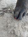
grave injury
bandaged dog
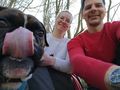
Proof


Achievements
Santu & Gefrierbrand earned the Land geohash achievement
|
Santu & Gefrierbrand earned the GeoTrash Geohash Achievement
|
Pedro the dog earned the Picnic achievement
|
Gefrierbrand & Santu earned the First Sip GeoSquishy Achievement
|
Pedro the dog earned the It's only a flesh wound Achievement
|