Difference between revisions of "2022-04-06 45 -121"
m (Location) |
Michael5000 (talk | contribs) |
||
| Line 40: | Line 40: | ||
== Achievements == | == Achievements == | ||
{{#vardefine:ribbonwidth|800px}} | {{#vardefine:ribbonwidth|800px}} | ||
| + | <gallery perrow="5"> | ||
| + | File:2022-04-06 45 -121 6.JPG|My first expedition to the (45,-121) section of Clackamas County. | ||
| + | </gallery> | ||
[[Category:Expeditions]] | [[Category:Expeditions]] | ||
[[Category:Expeditions with photos]] | [[Category:Expeditions with photos]] | ||
[[Category:Coordinates reached]] | [[Category:Coordinates reached]] | ||
{{location|US|OR|CC}} | {{location|US|OR|CC}} | ||
Latest revision as of 04:54, 7 April 2022
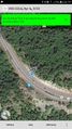
| Wed 6 Apr 2022 in 45,-121: 45.3070049, -121.8303935 geohashing.info google osm bing/os kml crox |
Location
On the side of U.S. 26, between Rhododendron and Government Camp.
Participants
Expedition
Having taken a pass on the chance to wander through a car lot in Gladstone yesterday, I thought I would probably take a pass on the chance to drive for an hour to stand on the side of a highway, too. But as the workday wore on, the idea of a drive in the country started to sound pretty good.
It was a clear spring day, and there were lots of great views of Mount Hood on the way out. A generous pull-out across the road from the hashpoint made it pretty easy to park safely. I crossed the highway, stood on the hashpoint, looked around a bit, and then went home.
Photos
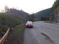
Parking Mrs.5000's car by the roadside.
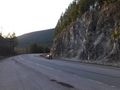
Somebody drives past the hashpoint.
I made it!

I celebrate another triumph.
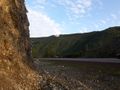
Looking back towards the car from ground zero.


Achievements
My first expedition to the (45,-121) section of Clackamas County.
