Difference between revisions of "2022-04-11 58 5"
From Geohashing
([live picture]Kyllingstad [https://openstreetmap.org/?mlat=58.74300370&mlon=5.94749180&zoom=16 @58.7430,5.9475]) |
(→Achievements) |
||
| (20 intermediate revisions by 3 users not shown) | |||
| Line 12: | Line 12: | ||
| date=2022-04-11 | | date=2022-04-11 | ||
}}<!-- edit as necessary --> | }}<!-- edit as necessary --> | ||
| − | |||
== Location == | == Location == | ||
<!-- where you've surveyed the hash to be --> | <!-- where you've surveyed the hash to be --> | ||
| + | The hash was on a slope in Kyllingstad, Gjesdal, Norway. | ||
== Participants == | == Participants == | ||
<!-- who attended: If you link to your wiki user name in this section, your expedition will be picked up by the various statistics generated for geohashing. You may use three tildes ~ as a shortcut to automatically insert the user signature of the account you are editing with. | <!-- who attended: If you link to your wiki user name in this section, your expedition will be picked up by the various statistics generated for geohashing. You may use three tildes ~ as a shortcut to automatically insert the user signature of the account you are editing with. | ||
--> | --> | ||
| − | + | *[[User:Pica42|Pica42]] | |
| − | |||
| − | |||
== Expedition == | == Expedition == | ||
<!-- how it all turned out. your narrative goes here. --> | <!-- how it all turned out. your narrative goes here. --> | ||
| − | + | I started the trip early in the morning, at 07:00. It was less than 400 meters in a straight line from where I parked to the hash. | |
| − | |||
| − | |||
== Photos == | == Photos == | ||
<!-- Insert pictures between the gallery tags using the following format: | <!-- Insert pictures between the gallery tags using the following format: | ||
| − | + | ||
--> | --> | ||
| − | <gallery | + | <gallery> |
Image:2022-04-11_58_5_Pica42_1649656921854.jpg|Kyllingstad [https://openstreetmap.org/?mlat=58.74300370&mlon=5.94749180&zoom=16 @58.7430,5.9475] | Image:2022-04-11_58_5_Pica42_1649656921854.jpg|Kyllingstad [https://openstreetmap.org/?mlat=58.74300370&mlon=5.94749180&zoom=16 @58.7430,5.9475] | ||
| + | Image:20220411_01.jpg|Me at the hash. | ||
| + | Image:20220411_02.jpg|View to the west. | ||
| + | Image:20220411_03.jpg|View to the south. | ||
| + | Image:20220411_04.jpg|View to the east. | ||
</gallery> | </gallery> | ||
| Line 42: | Line 42: | ||
<!-- Add any achievement ribbons you earned below, or remove this section --> | <!-- Add any achievement ribbons you earned below, or remove this section --> | ||
| − | |||
| − | |||
| − | |||
| − | + | __NOTOC__ | |
| − | |||
| − | |||
| − | |||
| − | |||
| − | |||
| − | |||
| − | |||
| − | |||
| − | |||
[[Category:Expeditions]] | [[Category:Expeditions]] | ||
| − | |||
[[Category:Expeditions with photos]] | [[Category:Expeditions with photos]] | ||
| − | |||
| − | |||
| − | |||
| − | |||
| − | |||
[[Category:Coordinates reached]] | [[Category:Coordinates reached]] | ||
| + | {{location|NO|11}} | ||
| + | {{land geohash |name=[[User:Pica42|Pica42]] |date=2022-04-11 |latitude=58 |longitude=5 }} | ||
| − | |||
| − | |||
| − | |||
| − | |||
| − | |||
| − | |||
| − | |||
| − | |||
| − | |||
| − | |||
| − | |||
| − | |||
| − | |||
| − | |||
| − | + | {{Two to the N achievement | |
| + | | count = 3 | ||
| + | | date = 2022-04-11 | ||
| + | | latitude = 58 | ||
| + | | longitude = 5 | ||
| + | | name = [[Pica42]] | ||
| + | | reached = true | ||
| + | | graticule = true | ||
| + | }} | ||
Latest revision as of 13:00, 20 July 2022
| Mon 11 Apr 2022 in 58,5: 58.7429682, 5.9475058 geohashing.info google osm bing/os kml crox |
Location
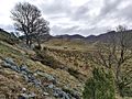
The hash was on a slope in Kyllingstad, Gjesdal, Norway.
Participants
Expedition
I started the trip early in the morning, at 07:00. It was less than 400 meters in a straight line from where I parked to the hash.
Photos
Kyllingstad @58.7430,5.9475
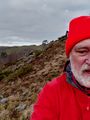
Me at the hash.
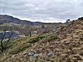
View to the west.
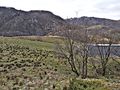
View to the south.
View to the east.


Achievements
Pica42 earned the Land geohash achievement
|

Pica42 earned the Two to the N achievement
by being the location of 23 expeditions on 2022-04-11 58 5 and is promoted to Level 3 (Coordinates reached).