Difference between revisions of "2022-05-09 44 -123"
Michael5000 (talk | contribs) (Created page with "{{subst:Expedition}}") |
m (Location) |
||
| (5 intermediate revisions by one other user not shown) | |||
| Line 1: | Line 1: | ||
| − | |||
| − | |||
| − | + | [[File:2022-05-09 44 -123 c.jpg|thumb|left]] | |
| − | |||
| − | + | {{meetup graticule | |
| − | |||
| lat={{#explode:{{SUBPAGENAME}}| |1}} | | lat={{#explode:{{SUBPAGENAME}}| |1}} | ||
| lon={{#explode:{{SUBPAGENAME}}| |2}} | | lon={{#explode:{{SUBPAGENAME}}| |2}} | ||
| Line 14: | Line 10: | ||
__NOTOC__ | __NOTOC__ | ||
== Location == | == Location == | ||
| − | + | ||
| + | In Filbert Meadows Park, in the Fir Grove neighborhood northwest of Eugene. | ||
== Participants == | == Participants == | ||
| − | |||
| − | |||
| − | + | * [[User:Michael5000|Michael5000]] | |
| − | |||
== Expedition == | == Expedition == | ||
| − | |||
| − | + | I ran an errand a few miles from home, and since I'd gone that far figured I might as well continue on for another 100 miles or so down I-5 to visit this hashpoint. | |
| − | + | ||
| + | Generally, it's hard to imagine an easier place to perform the geohashing ritual -- shuffle around until standing at the exact right place, take pictures, leave -- than in a city park. The wrinkle this time was that the hashpoint was right at the edge of a playground, and standing around taking apparently random photographs didn't seem like it would be calculated to bring out the best in the attendant parents. So, I wandered over to the park mosaic pictured above, and figured that might have to do. | ||
| + | |||
| + | But, just as I was about to move on, the parents and children all more or less simultaneously decided to move on, so I was able to swing back by and get a shot of the now-deserted playground from the hashpoint on its edge. | ||
| + | |||
| + | After the expedition, I went for a four-mile run along Eugene's terrific network of riverside trails, and then drove around a bit in the south end of the Willamette Valley before pointing the prow northward towards home. | ||
== Photos == | == Photos == | ||
| − | + | ||
| − | |||
| − | |||
<gallery perrow="5"> | <gallery perrow="5"> | ||
| + | File:2022-05-09 44 -123 c.jpg|I did not find any of these things, but I didn't really try. | ||
| + | File:2022-05-09 44 -123 d.jpg|View from the hashpoint. | ||
</gallery> | </gallery> | ||
== Achievements == | == Achievements == | ||
{{#vardefine:ribbonwidth|800px}} | {{#vardefine:ribbonwidth|800px}} | ||
| − | |||
| − | |||
| − | |||
| − | |||
| − | |||
| − | |||
| − | |||
| − | |||
| − | |||
| − | |||
| − | |||
| − | |||
| − | |||
| − | |||
| − | |||
[[Category:Expeditions]] | [[Category:Expeditions]] | ||
| − | |||
[[Category:Expeditions with photos]] | [[Category:Expeditions with photos]] | ||
| − | |||
| − | |||
| − | |||
| − | |||
| − | |||
[[Category:Coordinates reached]] | [[Category:Coordinates reached]] | ||
| − | + | {{location|US|OR|LE}} | |
| − | |||
| − | |||
| − | |||
| − | |||
| − | |||
| − | |||
| − | |||
| − | |||
| − | |||
| − | |||
| − | |||
| − | |||
| − | |||
| − | |||
| − | |||
| − | |||
| − | |||
Latest revision as of 01:42, 10 May 2022

| Mon 9 May 2022 in 44,-123: 44.1193613, -123.1489443 geohashing.info google osm bing/os kml crox |
Location
In Filbert Meadows Park, in the Fir Grove neighborhood northwest of Eugene.
Participants
Expedition
I ran an errand a few miles from home, and since I'd gone that far figured I might as well continue on for another 100 miles or so down I-5 to visit this hashpoint.
Generally, it's hard to imagine an easier place to perform the geohashing ritual -- shuffle around until standing at the exact right place, take pictures, leave -- than in a city park. The wrinkle this time was that the hashpoint was right at the edge of a playground, and standing around taking apparently random photographs didn't seem like it would be calculated to bring out the best in the attendant parents. So, I wandered over to the park mosaic pictured above, and figured that might have to do.
But, just as I was about to move on, the parents and children all more or less simultaneously decided to move on, so I was able to swing back by and get a shot of the now-deserted playground from the hashpoint on its edge.
After the expedition, I went for a four-mile run along Eugene's terrific network of riverside trails, and then drove around a bit in the south end of the Willamette Valley before pointing the prow northward towards home.
Photos
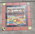
I did not find any of these things, but I didn't really try.
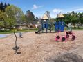
View from the hashpoint.
