Difference between revisions of "2022-05-14 46 -122"
Michael5000 (talk | contribs) (→Participants) |
m (Location) |
||
| Line 31: | Line 31: | ||
[[Category:Expeditions with photos]] | [[Category:Expeditions with photos]] | ||
[[Category:Coordinates reached]] | [[Category:Coordinates reached]] | ||
| + | {{location|US|WA|CW}} | ||
Latest revision as of 21:42, 15 May 2022
| Sat 14 May 2022 in 46,-122: 46.2534716, -122.8995156 geohashing.info google osm bing/os kml crox |
Location
On Hoyer Road, just south of Castle Rock
Participants
Expedition
It looked like nearby Castle Rock has a nice running trail, and I already knew it has a good Mexican restaurant, and what more do you need? There's an informal parking lot at the end of Hoyer Road for river access and what-not, and from there I strolled a couple hundred meters up to the hashpoint. Afterwards, I put in about four miles on the Castle Rock trail, which really is quite nice. Then, I took a wrong turn and ended up on the freeway onramp headed towards home. Fortunately, there are plenty of good Mexican restaurants along I-5 in Washington, so, I caught the next one south.
Photos
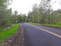
The hashpoint is going to be on the right side of the road, just past that blue pickup.

Here I am! I made it!

This witness post is witness to my accomplishment.
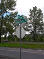
The intersection back at base camp.


