Difference between revisions of "2022-05-25 -37 144"
Felix Dance (talk | contribs) ([live picture]Sunset) |
m (Location) |
||
| (16 intermediate revisions by 3 users not shown) | |||
| Line 1: | Line 1: | ||
| − | + | [[Image:{{{image|2022-05-25_-37_144_Felix Dance_1653465160495.jpg}}}|thumb|left]] | |
| − | + | {{meetup graticule | |
| − | |||
| − | |||
| − | |||
| − | |||
| − | |||
| − | |||
| lat=-37 | | lat=-37 | ||
| lon=144 | | lon=144 | ||
| date=2022-05-25 | | date=2022-05-25 | ||
| − | }} | + | }} |
__NOTOC__ | __NOTOC__ | ||
== Location == | == Location == | ||
| − | + | In Fawkner cemetery. | |
== Participants == | == Participants == | ||
| − | < | + | * [[User:Felix Dance|Felix Dance]] |
| − | + | * [[User:Stevage|Stevage]] | |
| + | * [[User:Lachie|Lachie]] | ||
| + | * [[User:johnwrw|John]] | ||
| + | |||
| + | == Expedition == | ||
| + | A classic cemetery geohash! | ||
| + | |||
| + | Here is a list of some others in the area: | ||
| + | |||
| + | * [[2010-08-09 -37 144]] - Footscray Cemetery;<br/> | ||
| + | * [[2013-01-07 -37 145]] - Springvale Cemetery;<br/> | ||
| + | * [[2022-02-08 -37 144]] - Bacchus Marsh Cemetery;<br/> | ||
| + | |||
| + | With honourable mention: | ||
| + | |||
| + | * [[2016-07-15 -37 145]] - Accessed through the Arthurs Creek Cemetery, but just outside it. | ||
| + | |||
| + | For this expedition, the four intrepid cemetery-hashers met up with our bikes outside Felix's house (18 Temple St, Brunswick West, Vic., 3055, FYI). We then proceeded on wheel up the Upfield Bike Path towards Fawkner. | ||
| + | |||
| + | The sun was setting and turning the sky a deep (insert correct colour description here) while we rode into the darkening night. A detour from the usual bike route, now under construction, put us onto some rocky ballast and through to the Merlynston Station car park. A small gate in the fence of Fawkner Cemetery let us in. | ||
| − | + | Without too much faffing about we were there. We each circled the annoying, spiky tree to get as close as possible. The hash seemed to be right in the trunk. | |
| − | |||
| − | + | To celebrate success, we all got out beers and sat disrespectfully on the grave of a couple who died around 70 years ago. We talked about the recent federal election and how irritating a lot of news media has been. | |
| − | + | ||
| + | After an hour or so we departed to have dinner at the Post Office Hotel, where we continued to chat, this time trying to guess the number of common train stations between the metropolitan service and the regional V-Line service. There are 16. | ||
| + | |||
| + | After some sticky date pudding we departed the pub and each peeled off to our respective homes/other places of destination. | ||
== Tracklog == | == Tracklog == | ||
| − | + | {{ Tracklog | 20220525 170425 Fawkner cemetary geohash.gpx }} | |
== Photos == | == Photos == | ||
| − | |||
| − | |||
| − | |||
<gallery perrow="5"> | <gallery perrow="5"> | ||
| − | Image:2022-05-25_-37_144_Felix | + | Image:2022-05-25_-37_144_Felix Dance_1653465244214.jpg|GPS proof [https://openstreetmap.org/?mlat=-37.71172590&mlon=144.95337240&zoom=16 @-37.7117,144.9534] |
Image:2022-05-25_-37_144_Felix Dance_1653464935218.jpg|Upfield Line | Image:2022-05-25_-37_144_Felix Dance_1653464935218.jpg|Upfield Line | ||
| Line 44: | Line 56: | ||
Image:2022-05-25_-37_144_Felix Dance_1653464972142.jpg|Sunset | Image:2022-05-25_-37_144_Felix Dance_1653464972142.jpg|Sunset | ||
| + | |||
| + | Image:2022-05-25_-37_144_Felix Dance_1653464985553.jpg|Hash tree | ||
| + | |||
| + | Image:2022-05-25_-37_144_Felix Dance_1653465160495.jpg|Hash beers! | ||
| + | |||
| + | Image:2022-05-25_-37_144_Felix Dance_1653465276737.jpg|Gravestone at the hash | ||
| + | |||
| + | Image:2022-05-25_-37_144_stevage_1653532678214.jpg|Steve and Lachie | ||
| + | |||
| + | Image:2022-05-25_-37_144_stevage_1653532735107.jpg|Three quarters of the party with four quarters of the high vis. | ||
</gallery> | </gallery> | ||
== Achievements == | == Achievements == | ||
{{#vardefine:ribbonwidth|800px}} | {{#vardefine:ribbonwidth|800px}} | ||
| − | |||
| − | + | {{bicycle geohash | |
| − | |||
| − | |||
| − | + | | latitude = -37 | |
| + | | longitude = 144 | ||
| + | | date = 2022-05-25 | ||
| + | | name = [[User:Felix Dance|Felix Dance]], [[User:Stevage|Stevage]], [[User:Lachie|Lachie]] and [[User:johnwrw|John]] | ||
| + | | distance = up to 28 kms | ||
| + | | bothways = true (optional) | ||
| + | | image = 2022-05-25_-37_144_Felix Dance_1653464960278.jpg | ||
| − | + | }} | |
| − | + | {{ Two to the N achievement|count=6|latitude=-37|longitude=144|date=2022-05-25|name=[[User:Stevage|Stevage]]|reached=true }} | |
| − | [[ | ||
| − | |||
| − | |||
| − | |||
| − | |||
[[Category:Expeditions]] | [[Category:Expeditions]] | ||
| − | |||
[[Category:Expeditions with photos]] | [[Category:Expeditions with photos]] | ||
| − | |||
| − | |||
| − | |||
| − | |||
| − | |||
[[Category:Coordinates reached]] | [[Category:Coordinates reached]] | ||
| − | + | {{location|AU|VIC|MD}} | |
| − | |||
| − | |||
| − | |||
| − | |||
| − | |||
| − | |||
| − | |||
| − | |||
| − | |||
| − | |||
| − | |||
| − | |||
| − | |||
| − | |||
| − | |||
| − | |||
| − | |||
Latest revision as of 08:42, 28 May 2022

| Wed 25 May 2022 in -37,144: -37.7117485, 144.9533905 geohashing.info google osm bing/os kml crox |
Location
In Fawkner cemetery.
Participants
Expedition
A classic cemetery geohash!
Here is a list of some others in the area:
- 2010-08-09 -37 144 - Footscray Cemetery;
- 2013-01-07 -37 145 - Springvale Cemetery;
- 2022-02-08 -37 144 - Bacchus Marsh Cemetery;
With honourable mention:
- 2016-07-15 -37 145 - Accessed through the Arthurs Creek Cemetery, but just outside it.
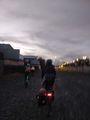
For this expedition, the four intrepid cemetery-hashers met up with our bikes outside Felix's house (18 Temple St, Brunswick West, Vic., 3055, FYI). We then proceeded on wheel up the Upfield Bike Path towards Fawkner.
The sun was setting and turning the sky a deep (insert correct colour description here) while we rode into the darkening night. A detour from the usual bike route, now under construction, put us onto some rocky ballast and through to the Merlynston Station car park. A small gate in the fence of Fawkner Cemetery let us in.
Without too much faffing about we were there. We each circled the annoying, spiky tree to get as close as possible. The hash seemed to be right in the trunk.
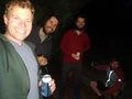
To celebrate success, we all got out beers and sat disrespectfully on the grave of a couple who died around 70 years ago. We talked about the recent federal election and how irritating a lot of news media has been.
After an hour or so we departed to have dinner at the Post Office Hotel, where we continued to chat, this time trying to guess the number of common train stations between the metropolitan service and the regional V-Line service. There are 16.
After some sticky date pudding we departed the pub and each peeled off to our respective homes/other places of destination.
Tracklog
Photos
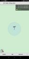
GPS proof @-37.7117,144.9534
Upfield Line
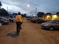
Station

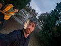
Selfie
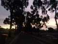
Sunset
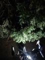
Hash tree
Hash beers!
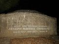
Gravestone at the hash
Steve and Lachie
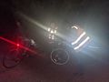
Three quarters of the party with four quarters of the high vis.


Achievements
Felix Dance, Stevage, Lachie and John earned the Bicycle geohash achievement
|
