Difference between revisions of "2022-06-03 -37 144"
m (Location) |
|||
| (One intermediate revision by one other user not shown) | |||
| Line 1: | Line 1: | ||
| − | + | {{meetup graticule | |
| − | |||
| − | |||
| − | |||
| − | |||
| − | |||
| − | |||
| − | |||
| − | |||
| lat=-37 | | lat=-37 | ||
| lon=144 | | lon=144 | ||
| date=2022-06-03 | | date=2022-06-03 | ||
| − | }} | + | }} |
__NOTOC__ | __NOTOC__ | ||
== Location == | == Location == | ||
| − | + | Kyneton - In a carpark for a butchers, or maybe just on the other side of the fence behind a football ground. | |
== Participants == | == Participants == | ||
| − | + | [[User:Johnwrw|John]] | |
| − | |||
| − | |||
| − | |||
| − | |||
== Expedition == | == Expedition == | ||
Woohoo! 100 successful geohashes for the Melbourne West -37 144 graticule | Woohoo! 100 successful geohashes for the Melbourne West -37 144 graticule | ||
| − | + | After the [[2022-05-28 -37 144|Brooklyn hash]] six days previously, the Melbourne West graticule was up to 99 coordinates successfully reached. Naturally I kept a very close eye on each day's coordinates as they were released, looking to get that up to 100 as soon as possible. | |
| + | |||
| + | When I saw the location for this day, seemingly very accessible in a carpark in central Kyneton I had to go. It was just a couple of Ks from the station. I probably wouldn't have bothered otherwise to get a train an hour each way just for the geohash without the promise of a nice ride involved at the other end too, (and I regrettably didn't have the time to turn part of the journey into a ride), but it was important to bring up Melbwest's ton so off I set. And I don't think I'd ever been to Kyneton, so it was nice to have the chance to have a little look about. | ||
| + | |||
| + | I trundled over to Footscray to get the 1:14pm train to Epsom (i.e., Bendigo), and made it comfortably. I read a bit more of Scott Ludlam's book on the train, and except for when I had to move my bike at Sunbury to release someone's suitcase that I had boxed in, the trip was uneventful. | ||
| + | |||
| + | I arrived at Kyneton's beautiful old bluestone station a bit after 2, and headed into town. Down over the Campaspe river, past the velodrome and botanic gardens and up the main street. I passed several pubs, and I wondered if any of them would be visible from the hash point, for the pub geohash achievement. | ||
| + | |||
| + | According to google's satellite imagery, the hashpoint was seemingly on the edge of a carpark for Hardwicks Butchers, though according to the plain map it was just on the other side of the property boundary, behind a couple of football ovals. Google maps labelled the closest oval as "Dave Nutman Jr's Oval" but I didn't see this name on other maps, and nor as it turned out did I see it anywhere at the oval itself. | ||
| + | |||
| + | I got to the butchers, and I was glad to be there during business hours, the sign read that the gates would be locked at close of trade each day. In terms of said trade, it looked to be doing well, there was a steady stream of customers coming and going, meaning the carpark was closer to full than empty. I was a little concerned that the comers and goers might take issue with me suspiciously loitering and taking photos near their cars, but what could I do? I walked in, made my way to the spot, and got the app to say I was within a metre without much difficulty. I snapped a couple of quick pics and made my way out of there before anyone got too suspicious. | ||
| + | |||
| + | The possibility was still there though that the actual hashpoint itself may have been on the other side of the fence, even if I had got close enough from this side. It seemed for the best that I try and get around to that side too. I could have quite easily scaled the fence, but that was certain to have aroused suspicions from any lookers on, so I thought I had better walk around. | ||
| + | |||
| + | Walk around I did. The gates to the ovals were wide open, and there a electronic roadside-style sign advertising the game the day after for all who passed. I got around to the point, and sure enough I got the app to say I was within a metre just as easily on this side. So in the end it is a bit of a mystery which side the point actually was on. But I covered both so all was well. | ||
| + | |||
| + | On the footy oval side, right next to the point was a corrigated iron building, labelled "C. H. Watts Wool Pavilion", and on the side facing the street there was a mural for Kyneton Garden Supplies, featuring the Kyneton Agricultural Society, and a Kyneton Show scene, which is apparently held on the ovals. In the geohashing chat, [[User:Felix_Dance|Felix]] informed me that he had in fact bought chooks at this very spot last year. | ||
| + | |||
| + | Unfortunately, from the hash itself away from the road, no pubs were visible. But it was only a tiny distance out to the main street where several pubs were visible. Heading along the road west I could see the Royal George, a big old pub, so I went that way to try to find a drink. Closer inspection revealed however, that it wasn't really operating as a pub any more, but it was a strange shop with many plants, a cocktail bar, and a fancy bottle shop. Not really what I was looking for. | ||
| + | |||
| + | Heading south down the main street, a couple more pubs were visible from the butchers, or at least I could make out their Carlton Draught signs hanging out into the street a few hundred metres away. The first one I tried here also bore no fruit. The Shamrock Hotel was open for lunch and dinner, but apparently closed in between. It was a case of third time lucky, however. Just beyond the Shamrock was the Kyneton Hotel, an art deco building formerly known as the Newmarket Hotel. Ned Kelly had apparently spent a bit over a week here in 1870 <ref>https://thekynetonhotel.com.au/</ref> though this must have been in a prior architectural instantiation. This pub was open and willing to serve me a pot of a hazy pale ale to celebrate 100 geohashes reached in Melbourne West, even though the door through which I entered seemed to take the bartender by surprise. | ||
| + | |||
| + | I think the fact the pub was only visible from the street and not the hash itself, and even then only quite distantly, makes this a close but no cigar attempt at the pub geohash achievement. | ||
| + | |||
| + | I downed my pot fairly rapidly, having to get moving for a train to catch. I raced back down towards the station, and was there with a couple of minutes to spare, but of course the train was 5 minutes late. And when the train finally arrived there wasn't even a proper spot to put bikes! But it was okay, I found enough room somewhere to secure my bike mostly out of the way. The journey home was uneventful. Several of the passengers were clearly heading off to the football that evening between the dogs and the cats, which was also what constituted my plans for the evening (alas, the dogs went on to lose). | ||
| + | |||
| + | I snuck in a visit to Cheaper Buy Miles on my ride from Footscray station, and returned home just before 5pm. | ||
| − | |||
| − | |||
== Photos == | == Photos == | ||
| − | + | ||
| − | |||
| − | |||
<gallery perrow="5"> | <gallery perrow="5"> | ||
| Line 64: | Line 74: | ||
</gallery> | </gallery> | ||
| − | == | + | == References == |
{{#vardefine:ribbonwidth|800px}} | {{#vardefine:ribbonwidth|800px}} | ||
| − | |||
| − | |||
| − | |||
| − | |||
| − | |||
| − | |||
| − | |||
| − | |||
| − | |||
| − | |||
| − | |||
| − | |||
| − | |||
| − | |||
| − | |||
| − | |||
| − | |||
| − | |||
| − | |||
| − | |||
[[Category:Coordinates reached]] | [[Category:Coordinates reached]] | ||
| − | + | [[Category:Expeditions]] | |
| − | |||
| − | |||
| − | |||
| − | |||
| − | |||
| − | |||
| − | [[Category: | ||
| − | + | [[Category:Expeditions with photos]] | |
| − | [[Category: | + | {{location|AU|VIC|MR}} |
| − | |||
| − | |||
| − | |||
| − | |||
| − | |||
Latest revision as of 13:42, 4 June 2022
| Fri 3 Jun 2022 in -37,144: -37.2445038, 144.4544887 geohashing.info google osm bing/os kml crox |
Location
Kyneton - In a carpark for a butchers, or maybe just on the other side of the fence behind a football ground.
Participants
Expedition
Woohoo! 100 successful geohashes for the Melbourne West -37 144 graticule
After the Brooklyn hash six days previously, the Melbourne West graticule was up to 99 coordinates successfully reached. Naturally I kept a very close eye on each day's coordinates as they were released, looking to get that up to 100 as soon as possible.
When I saw the location for this day, seemingly very accessible in a carpark in central Kyneton I had to go. It was just a couple of Ks from the station. I probably wouldn't have bothered otherwise to get a train an hour each way just for the geohash without the promise of a nice ride involved at the other end too, (and I regrettably didn't have the time to turn part of the journey into a ride), but it was important to bring up Melbwest's ton so off I set. And I don't think I'd ever been to Kyneton, so it was nice to have the chance to have a little look about.
I trundled over to Footscray to get the 1:14pm train to Epsom (i.e., Bendigo), and made it comfortably. I read a bit more of Scott Ludlam's book on the train, and except for when I had to move my bike at Sunbury to release someone's suitcase that I had boxed in, the trip was uneventful.
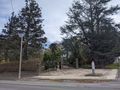
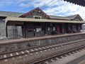
I arrived at Kyneton's beautiful old bluestone station a bit after 2, and headed into town. Down over the Campaspe river, past the velodrome and botanic gardens and up the main street. I passed several pubs, and I wondered if any of them would be visible from the hash point, for the pub geohash achievement.
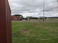
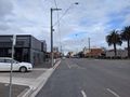
According to google's satellite imagery, the hashpoint was seemingly on the edge of a carpark for Hardwicks Butchers, though according to the plain map it was just on the other side of the property boundary, behind a couple of football ovals. Google maps labelled the closest oval as "Dave Nutman Jr's Oval" but I didn't see this name on other maps, and nor as it turned out did I see it anywhere at the oval itself.
I got to the butchers, and I was glad to be there during business hours, the sign read that the gates would be locked at close of trade each day. In terms of said trade, it looked to be doing well, there was a steady stream of customers coming and going, meaning the carpark was closer to full than empty. I was a little concerned that the comers and goers might take issue with me suspiciously loitering and taking photos near their cars, but what could I do? I walked in, made my way to the spot, and got the app to say I was within a metre without much difficulty. I snapped a couple of quick pics and made my way out of there before anyone got too suspicious.
The possibility was still there though that the actual hashpoint itself may have been on the other side of the fence, even if I had got close enough from this side. It seemed for the best that I try and get around to that side too. I could have quite easily scaled the fence, but that was certain to have aroused suspicions from any lookers on, so I thought I had better walk around.
Walk around I did. The gates to the ovals were wide open, and there a electronic roadside-style sign advertising the game the day after for all who passed. I got around to the point, and sure enough I got the app to say I was within a metre just as easily on this side. So in the end it is a bit of a mystery which side the point actually was on. But I covered both so all was well.
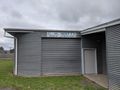
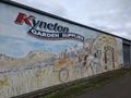
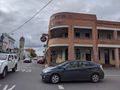
On the footy oval side, right next to the point was a corrigated iron building, labelled "C. H. Watts Wool Pavilion", and on the side facing the street there was a mural for Kyneton Garden Supplies, featuring the Kyneton Agricultural Society, and a Kyneton Show scene, which is apparently held on the ovals. In the geohashing chat, Felix informed me that he had in fact bought chooks at this very spot last year.
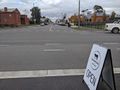
Unfortunately, from the hash itself away from the road, no pubs were visible. But it was only a tiny distance out to the main street where several pubs were visible. Heading along the road west I could see the Royal George, a big old pub, so I went that way to try to find a drink. Closer inspection revealed however, that it wasn't really operating as a pub any more, but it was a strange shop with many plants, a cocktail bar, and a fancy bottle shop. Not really what I was looking for.
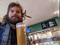
Heading south down the main street, a couple more pubs were visible from the butchers, or at least I could make out their Carlton Draught signs hanging out into the street a few hundred metres away. The first one I tried here also bore no fruit. The Shamrock Hotel was open for lunch and dinner, but apparently closed in between. It was a case of third time lucky, however. Just beyond the Shamrock was the Kyneton Hotel, an art deco building formerly known as the Newmarket Hotel. Ned Kelly had apparently spent a bit over a week here in 1870 [1] though this must have been in a prior architectural instantiation. This pub was open and willing to serve me a pot of a hazy pale ale to celebrate 100 geohashes reached in Melbourne West, even though the door through which I entered seemed to take the bartender by surprise.
I think the fact the pub was only visible from the street and not the hash itself, and even then only quite distantly, makes this a close but no cigar attempt at the pub geohash achievement.
I downed my pot fairly rapidly, having to get moving for a train to catch. I raced back down towards the station, and was there with a couple of minutes to spare, but of course the train was 5 minutes late. And when the train finally arrived there wasn't even a proper spot to put bikes! But it was okay, I found enough room somewhere to secure my bike mostly out of the way. The journey home was uneventful. Several of the passengers were clearly heading off to the football that evening between the dogs and the cats, which was also what constituted my plans for the evening (alas, the dogs went on to lose).
I snuck in a visit to Cheaper Buy Miles on my ride from Footscray station, and returned home just before 5pm.
Photos
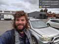
Carpark side @-37.2445,144.4545
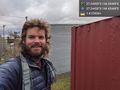
Footy ground side @-37.2445,144.4545
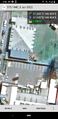
GPS proof
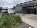
Carpark entrance
Dave Nutman Jr's oval
Wool pavilion
Garden supplies
View from footpath one way
And the other
Beer
Pub
Botanic gardens
Train station


