Difference between revisions of "2022-06-27 52 9"
From Geohashing
(new report) |
m (Adding hours) |
||
| (One intermediate revision by one other user not shown) | |||
| Line 29: | Line 29: | ||
{{#vardefine:ribbonwidth|100%}} | {{#vardefine:ribbonwidth|100%}} | ||
{{land geohash|date=2022-06-27|latitude=52|longitude=9|name=[[User:Fippe|Fippe]]|image=2022-06-27 52 9 05 Geohash.jpg}} | {{land geohash|date=2022-06-27|latitude=52|longitude=9|name=[[User:Fippe|Fippe]]|image=2022-06-27 52 9 05 Geohash.jpg}} | ||
| + | {{last man standing|date=2022-06-27|latitude=52|longitude=9|name=[[User:Fippe|Fippe]]}} | ||
__NOTOC__ | __NOTOC__ | ||
| Line 35: | Line 36: | ||
[[Category:Expeditions with photos]] | [[Category:Expeditions with photos]] | ||
{{location|DE|NI|H}} | {{location|DE|NI|H}} | ||
| − | {{user categories|user=Fippe|tram=24|train=35|foot=7}} | + | {{user categories|user=Fippe|tram=24|train=35|foot=7|hours=19}} |
Latest revision as of 20:00, 11 December 2022
| Mon 27 Jun 2022 in 52,9: 52.4095207, 9.4867752 geohashing.info google osm bing/os kml crox |
Location
This Geohash is located on a path in Luthe.
Participants
Expedition
I took the tram to the central station, the train to Wunstorf, and walked the rest. It had rained a bit on the way.
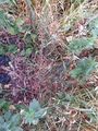
When I got to the site of the Geohash, I noticed flattened grass at the side of the path, clearly someone had been here before me. Was it the same ninja as the one at 2022-06-22 52 9?
After recording proof, I walked to the Dedensen/Gümmer station. One of the paths was very overgrown with high, wet grass, was it even a path? Once at the station I took the train to Nordstadt, and the tram back home.
Photos

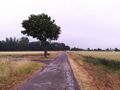
On the way to the Geohash
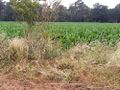
Someone had been here
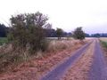
The site of the Geohash
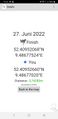
Proof
The Geohash


Tracklog
Ribbons
Fippe earned the Land geohash achievement
|
Fippe earned the Last man standing achievement
|