Difference between revisions of "2022-07-08 45 -120"
Michael5000 (talk | contribs) (→Location) |
Michael5000 (talk | contribs) (→Achievements) |
||
| (6 intermediate revisions by 2 users not shown) | |||
| Line 18: | Line 18: | ||
== Participants == | == Participants == | ||
| − | |||
| − | |||
| − | + | * [[User:Michael5000|Michael5000]] | |
| − | + | * [[User:Mrs.5000|Mrs.5000]] | |
== Expedition == | == Expedition == | ||
| − | |||
| − | + | You probably remember that on June 5, 2019, the hashpoints were at .6097674 and .2047254, and today they were at .6115230 and .2101686. At the middle latitudes that's an offset of about, what... 1500 feet? about half a kilometer? So, as we drove up to this hashpoint, I was able to point the location of [[2019-06-05 45 -120]] out to Mrs.5000. "I think it was over by that shed," I said, correctly as it turns out. | |
| − | + | ||
| + | So, on Wednesday we got three hashpoints ending in the Tri Cities with [[2022-07-06 46 -119]], and then on Thursday we went to Pendleton and did some things that didn't involve hashpoints. Today was Friday, and there were several tempting geohash opportunities in the region. We decided to skip the more distant ones at Seattle ([[2022-07-08 47 -122|but Thomcat got that one]]) and Boise (which may have gone unclaimed), and look into two or three that were closer to hand and more or less on the way home to Portland. | ||
| + | |||
| + | From Pendleton, getting to this one was just a matter of getting on to I-84 and driving west for an hour, taking the Arlington exit onto Oregon 19, and then turning right onto Cedar Springs Lane. We pulled off the side of the road, scrambled down a little embankment, climbed over some railroad tracks, and there we were. | ||
| + | |||
| + | For a massive industrial waste disposal site, the facility here is nothing if not discreet, and is actually somewhat pretty. Trains and trucks of trash occasionally pull in, and big forklifts take the containers of waste, and... something happens. You don't actually see much trash, and there's no smell, so there's just a mild buzz of activity that, although it's on a pretty big scale, still gets dwarfed by the open landscape. | ||
| + | |||
| + | Our plan up to this point had been to continue one graticule west on I-84, continuing in the direction of home, to another accessible-looking hashpoint in The Dalles. But when we got back to Highway 19, I found myself saying "Let's try the one south of here" and Mrs.5000 found herself saying "OK, sure!" That's how we ended up at [[2022-07-08 44 -120]] | ||
== Photos == | == Photos == | ||
| − | + | ||
| − | |||
| − | |||
<gallery perrow="5"> | <gallery perrow="5"> | ||
| + | File:2022-07-08 45 -120 a.jpg|We are standing on a hashpoint! | ||
| + | File:2022-07-08 45 -120 d.jpg|Trainloads of garbage. | ||
| + | File:2022-07-08 45 -120 c.jpg|A truck heads out to collect more garbage. | ||
| + | File:2022-07-08 45 -120 b.jpg|Windmills on the eastern horizon. | ||
</gallery> | </gallery> | ||
== Achievements == | == Achievements == | ||
{{#vardefine:ribbonwidth|800px}} | {{#vardefine:ribbonwidth|800px}} | ||
| − | |||
| − | + | *Mrs.5000's first successful expedition to the Goldendale graticule and to Gilliam County. | |
| − | + | {{Minesweeper geohash | |
| − | + | | graticule = [[Goldendale, Washington]] | |
| + | | ranknumber = 4 | ||
| + | | s = true | ||
| + | | w = true | ||
| + | | nw = true | ||
| + | | ne = true | ||
| + | | name = [[User:Mrs.5000|Mrs.5000]] | ||
| + | }} | ||
| + | |||
| + | ...but [[2022-07-08 45 -120|a successful adventure a few hours later]] would bump that up to Level 5! | ||
| − | + | Also: | |
| − | + | {{Minesweeper geohash | |
| − | + | | graticule = [[Mt. Rainier, Washington]] | |
| − | [[ | + | | ranknumber = 5 |
| − | + | | se = true | |
| + | | s = true | ||
| + | | sw = true | ||
| + | | nw = true | ||
| + | | n = true | ||
| + | | name = [[User:Mrs.5000|Mrs.5000]] | ||
| + | }} | ||
| − | |||
| − | |||
[[Category:Expeditions]] | [[Category:Expeditions]] | ||
| − | |||
[[Category:Expeditions with photos]] | [[Category:Expeditions with photos]] | ||
| − | |||
| − | |||
| − | |||
| − | |||
| − | |||
[[Category:Coordinates reached]] | [[Category:Coordinates reached]] | ||
| − | + | {{location|US|OR|GI}} | |
| − | |||
| − | |||
| − | |||
| − | |||
| − | |||
| − | |||
| − | |||
| − | |||
| − | |||
| − | |||
| − | |||
| − | |||
| − | |||
| − | |||
| − | |||
| − | |||
| − | |||
Latest revision as of 19:07, 10 July 2022
| Fri 8 Jul 2022 in 45,-120: 45.6115230, -120.2101686 geohashing.info google osm bing/os kml crox |
Location
Off of Cedar Springs Lane, five or six miles south of the Columbia and just south of the big waste facility in Gilliam County.
Participants
Expedition
You probably remember that on June 5, 2019, the hashpoints were at .6097674 and .2047254, and today they were at .6115230 and .2101686. At the middle latitudes that's an offset of about, what... 1500 feet? about half a kilometer? So, as we drove up to this hashpoint, I was able to point the location of 2019-06-05 45 -120 out to Mrs.5000. "I think it was over by that shed," I said, correctly as it turns out.
So, on Wednesday we got three hashpoints ending in the Tri Cities with 2022-07-06 46 -119, and then on Thursday we went to Pendleton and did some things that didn't involve hashpoints. Today was Friday, and there were several tempting geohash opportunities in the region. We decided to skip the more distant ones at Seattle (but Thomcat got that one) and Boise (which may have gone unclaimed), and look into two or three that were closer to hand and more or less on the way home to Portland.
From Pendleton, getting to this one was just a matter of getting on to I-84 and driving west for an hour, taking the Arlington exit onto Oregon 19, and then turning right onto Cedar Springs Lane. We pulled off the side of the road, scrambled down a little embankment, climbed over some railroad tracks, and there we were.
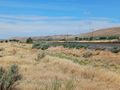
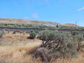
For a massive industrial waste disposal site, the facility here is nothing if not discreet, and is actually somewhat pretty. Trains and trucks of trash occasionally pull in, and big forklifts take the containers of waste, and... something happens. You don't actually see much trash, and there's no smell, so there's just a mild buzz of activity that, although it's on a pretty big scale, still gets dwarfed by the open landscape.
Our plan up to this point had been to continue one graticule west on I-84, continuing in the direction of home, to another accessible-looking hashpoint in The Dalles. But when we got back to Highway 19, I found myself saying "Let's try the one south of here" and Mrs.5000 found herself saying "OK, sure!" That's how we ended up at 2022-07-08 44 -120
Photos

We are standing on a hashpoint!
Trainloads of garbage.
A truck heads out to collect more garbage.
Windmills on the eastern horizon.


Achievements
- Mrs.5000's first successful expedition to the Goldendale graticule and to Gilliam County.
Mrs.5000 achieved level 4 of the Minesweeper Geohash achievement
|
...but a successful adventure a few hours later would bump that up to Level 5!
Also:
Mrs.5000 achieved level 5 of the Minesweeper Geohash achievement
|