Difference between revisions of "2022-07-16 50 9"
(Created page with "{{meetup graticule | date = 2022-07-16 | lat = 50 | lon = 9 }} == Location == Currently vacant meadow near the village of Waltersbrück, between wikipedia:Borken,_Hes...") |
m (Location) |
||
| Line 50: | Line 50: | ||
[[Category:Coordinates reached]] | [[Category:Coordinates reached]] | ||
[[Category:Expeditions with photos]] | [[Category:Expeditions with photos]] | ||
| + | {{location|DE|HE|HR}} | ||
Latest revision as of 20:42, 16 July 2022
| Sat 16 Jul 2022 in 50,9: 50.9917831, 9.2057052 geohashing.info google osm bing/os kml crox |
Location
Currently vacant meadow near the village of Waltersbrück, between Borken and Treysa.
Participants
Expedition
At four o'clock I arrived in Zimmersrode, a small town north of the location, with a train of the HLB - quite the opposite of a high-speed train.
From there I walked through beautiful fields to my very first Geohash, only being disturbed by the noise of the nearby Autobahn. Before arriving, I went through the small village of Waltersbrück, where cabbage was advertised several times, and at one point also Christmas trees - in July. Leaving the village, another cabbage sign pointed me down a small road to the Geohash.
And there I was already, next to a fenced off meadow. Since there were no animals to be seen and I didn't want to have walked all the way for nothing, I scrambled underneath the fence and searched for the exact position between dried-up cow piles. Now I was finally standing in the middle of the empty meadow, with a lovely view of a farm down the valley.
Eventually I completed my journey with a short hike to Treysa, where I was going to catch a somewhat faster train back south. Mission accomplished!
Photos
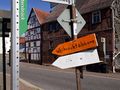
Advertisement for cabbage and Christmas trees.
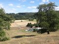
View down from the Geohash.
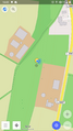
Screenshot of OsmAnd, kind of proofing that I was there.
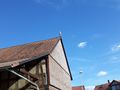
A stork on a roof top on my way back.


Achievements
oxzi earned the Land geohash achievement
|
