Difference between revisions of "2022-07-18 58 5"
From Geohashing
(→Photos) |
(→Achievements) |
||
| (13 intermediate revisions by 3 users not shown) | |||
| Line 15: | Line 15: | ||
== Location == | == Location == | ||
<!-- where you've surveyed the hash to be --> | <!-- where you've surveyed the hash to be --> | ||
| − | A headland that juts out into Lutsivatnet. | + | A headland that juts out into Lutsivatnet, Sandnes, Norway. |
== Participants == | == Participants == | ||
<!-- who attended: If you link to your wiki user name in this section, your expedition will be picked up by the various statistics generated for geohashing. You may use three tildes ~ as a shortcut to automatically insert the user signature of the account you are editing with. | <!-- who attended: If you link to your wiki user name in this section, your expedition will be picked up by the various statistics generated for geohashing. You may use three tildes ~ as a shortcut to automatically insert the user signature of the account you are editing with. | ||
--> | --> | ||
| − | [[User:Pica42|Pica42]] | + | *[[User:Pica42|Pica42]] |
== Plans == | == Plans == | ||
| Line 27: | Line 27: | ||
== Expedition == | == Expedition == | ||
<!-- how it all turned out. your narrative goes here. --> | <!-- how it all turned out. your narrative goes here. --> | ||
| + | The trip to today's hashpoint took place in an area near Lake Lutsivannet in Sandnes municipality, Norway. I had to walk through an area where cows were grazing. It was very wet and dirty so it took longer to get there than I had planned. Still, reaching the hashpoint was no problem. | ||
== Tracklog == | == Tracklog == | ||
| Line 38: | Line 39: | ||
Image:2022-07-18_58_5_Pica42_1658129636223.jpg|Lutsi [https://openstreetmap.org/?mlat=58.87522780&mlon=5.85938330&zoom=16 @58.8752,5.8594] | Image:2022-07-18_58_5_Pica42_1658129636223.jpg|Lutsi [https://openstreetmap.org/?mlat=58.87522780&mlon=5.85938330&zoom=16 @58.8752,5.8594] | ||
| − | Image: | + | Image:20220718 093215.jpg|View to Storevågen |
| − | Image:20220718 | + | Image:20220718 093221.jpg|View to the northwest |
| − | + | Image:20220718 093226.jpg|View to the southwest | |
| − | + | Image:20220718 094044.jpg|View to Forenessunda | |
</gallery> | </gallery> | ||
| Line 48: | Line 49: | ||
<!-- Add any achievement ribbons you earned below, or remove this section --> | <!-- Add any achievement ribbons you earned below, or remove this section --> | ||
| − | |||
| − | |||
| − | |||
| − | |||
| − | |||
| − | |||
| − | |||
| − | |||
| − | |||
| − | |||
| − | |||
| − | |||
| − | |||
| − | |||
[[Category:Expeditions]] | [[Category:Expeditions]] | ||
| − | |||
[[Category:Expeditions with photos]] | [[Category:Expeditions with photos]] | ||
| − | |||
| − | |||
| − | |||
| − | |||
| − | |||
[[Category:Coordinates reached]] | [[Category:Coordinates reached]] | ||
| + | {{location|NO|11}} | ||
| − | + | {{land geohash |name=[[User:Pica42|Pica42]] |date=2022-07-18 |latitude=58 |longitude=5 }} | |
| − | |||
| − | |||
| − | |||
| − | |||
| − | |||
| − | |||
| − | [[ | ||
| − | |||
| − | |||
| − | |||
| − | |||
| − | |||
| − | |||
| − | + | {{Two to the N achievement | |
| + | | count = 4 | ||
| + | | date = 2022-07-19 | ||
| + | | latitude = 58 | ||
| + | | longitude = 5 | ||
| + | | name = Pica42 | ||
| + | | global = 16 | ||
| + | | reached = true | ||
| + | | retro = true | ||
| + | | graticule = true | ||
| + | }} | ||
Latest revision as of 16:32, 19 November 2022
| Mon 18 Jul 2022 in 58,5: 58.8752307, 5.8593802 geohashing.info google osm bing/os kml crox |
Location
A headland that juts out into Lutsivatnet, Sandnes, Norway.
Participants
Plans
Expedition
The trip to today's hashpoint took place in an area near Lake Lutsivannet in Sandnes municipality, Norway. I had to walk through an area where cows were grazing. It was very wet and dirty so it took longer to get there than I had planned. Still, reaching the hashpoint was no problem.
Tracklog
Photos

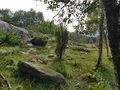
Lutsi @58.8752,5.8594
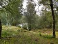
View to Storevågen
View to the northwest
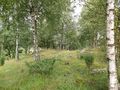
View to the southwest
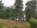
View to Forenessunda


Achievements
Pica42 earned the Land geohash achievement
|

Pica42 earned the Two to the N achievement
by being the location of 24 expeditions on 2022-07-19 58 5 and is promoted to Level 4 (Coordinates reached).